
Río Inabón facts for kids
Quick facts for kids Río Inabón |
|
|---|---|
.jpg)
Rio Inabon in Barrio Real in Ponce, Puerto Rico
|
|
| Lua error in Module:Location_map at line 420: attempt to index field 'wikibase' (a nil value).
Location of mouth
|
|
| Commonwealth | Puerto Rico |
| Municipality | Ponce |
| Physical characteristics | |
| Main source | Cerro Camacho, Barrio Anón, Ponce (near Jayuya) 4,100 feet (1,200 m) 17°58′08″N 66°33′30″W / 17.9688559°N 66.5582270°W |
| River mouth | Caribbean Sea 0 feet (0 m) |
| Length | 19.89 miles (32.01 km) |
| Basin features | |
| Progression | Anón Real Coto Laurel Capitanejo/Vayas |
| River system | Río Inabón |
| Basin size | 38.18 sq mi (98.9 km2) |
| Tributaries |
|

The Río Inabón is an important river in Ponce, Puerto Rico. It is one of 14 rivers in the area. At about 32 kilometers (20 miles) long, it is the second longest river in Ponce. Only the Río Jacaguas is longer.
The Río Inabón gets its water from several smaller streams. These include the Río Anón, Río Guayo, and Emajagua Brook. It also gets water from Río Bacas and Río de las Raices. The river starts very high up in the mountains. It begins about 1,200 meters (4,100 feet) above sea level. This makes it one of the highest starting points for any river in Puerto Rico! The area that collects water for the river, called its watershed, covers about 99 square kilometers (38 square miles). This is the second largest watershed among Ponce's rivers.
Contents
Where Does Río Inabón Start and Flow?
The Río Inabón begins in a place called Cerro Camacho. This is in the Anón area, close to Jayuya. From there, the river mostly flows next to PR-511. It passes through different neighborhoods like Anón, Real, Coto Laurel, and then Capitanejo and Vayas. Finally, it reaches the Caribbean Sea.
How Is the River Used?
The Río Inabón is very important for the local community. An old agreement from 1898 gives a local family, the Serrallés family, special rights to use the river's water. They use this water to make DonQ Rum.
Today, the Río Inabón is also a popular spot for swimming in southern Puerto Rico. Many people enjoy its cool waters. The river also helps fill about 10 private reservoirs in the Ponce area. These reservoirs store water for various uses.
Keeping the River Clean
Sometimes, rivers can get dirty from nearby homes. In 2011, a local leader named Víctor Vassallo Anadón worked to help keep the Río Inabón clean. He suggested a plan to improve the sewer systems for people living near the river. This helps stop dirty water from getting into the river.
Special Plants Near the River
A special type of fern called Thelypteris inabonensis grows near where the Río Inabón starts. It is also found in the Toro Negro State Forest. This fern is considered an endangered species. This means it is rare and needs protection to survive.
River Flow and Flooding
The amount of water flowing in the Río Inabón is controlled by special gates at Toa Vaca Lake. This lake is in the town of Villalba. The river usually has a strong flow of about 425 cubic meters (15,000 cubic feet) of water per second.
However, the Río Inabón can overflow easily when there are heavy rains. This can cause flash floods, where the water level rises very quickly. People have sometimes needed rescuing when the river has flooded. Because the river is close to Aeropuerto Mercedita (Mercedita Airport), heavy rains and floods can sometimes affect airport operations. This happened during Hurricane Maria in September 2017.
Images for kids
-
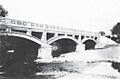
Bridge over Río Inabón on PR-1 between Ponce and Santa Isabel in 1920.
_-_photograph_-_page_158.jpg)
See also
 In Spanish: Río Inabón para niños
