
Jayuya, Puerto Rico facts for kids
Quick facts for kids
Jayuya
Municipio Autónomo de Jayuya
|
|||
|---|---|---|---|
|
Town and Municipality
|
|||

Lush vegetation and mountains in Jayuya
|
|||
|
|||
| Nickname(s):
La Capital Indigena
|
|||
| Anthem: "Ante nos se yergue" | |||

Map of Puerto Rico highlighting Jayuya Municipality
|
|||
| Sovereign state | |||
| Commonwealth | |||
| Settled | 1878 | ||
| Founded | March 9, 1911 | ||
| Founded by | Diego Maldonado | ||
| Named for | Hayuya | ||
| Barrios | |||
| Area | |||
| • Total | 39.4 sq mi (102.1 km2) | ||
| Elevation | 1,420 ft (430 m) | ||
| Population
(2020)
|
|||
| • Total | 14,779 | ||
| • Rank | 70th in Puerto Rico | ||
| • Density | 374.90/sq mi (144.75/km2) | ||
| Racial groups | |||
| • 2020 Census | 52.4% Multiracial 23.3% White 7.5% Black 0.5% American Ind/AN 21.3% Other |
||
| Time zone | UTC−4 (AST) | ||
| ZIP Code |
00664
|
||
| Area code(s) | 787/939 | ||
| Major routes | |||


Jayuya (pronounced ha-YOO-yah) is a town and municipality in Puerto Rico. It is located in the central mountain region of the island. Jayuya is north of Ponce, east of Utuado, and west of Ciales.
The town is divided into 10 areas called barrios, plus Jayuya Pueblo, which is the main downtown area. Jayuya is the most important city in its local area.
Jayuya is named after Hayuya, a leader of the Taíno people, who were the native inhabitants of Puerto Rico. The town is famous for its skilled wood carvers. You can find statues and busts by the Puerto Rican artist Tomás Batista here. These include a statue of Nemesio Canales and a bust of Chief Hayuya.
Contents
History of Jayuya
The town of Jayuya was officially founded in 1911. However, people who were not native to the island lived in this area as early as 1878. At that time, a small community grew there. It was quite separate from the bigger cities along the coasts.
Towards the end of the 1800s, the town became very important for growing coffee. This helped the local economy a lot. By 1911, when it became an official municipality, Jayuya had more than 9,000 people living there.
In 1950, Jayuya was the site of the Jayuya Uprising. This was a revolt against the United States government led by Blanca Canales. She was a social worker, and her cousins, Elio and Doris Torresola, also took part. Canales led a group into the main town square and declared Puerto Rico an independent republic. The police station was attacked, telephone lines were cut, and the post office was burned. The group held the town for three days. The town suffered damage during a military action by the Puerto Rico National Guard. News of this event was mainly reported within Puerto Rico.

In September 2017, Hurricane Maria hit Puerto Rico. The people of Jayuya had to collect spring water because of the damage. After the hurricane, community members gathered at the local high school to start rescue and repair efforts. Many wooden buildings were destroyed.
Geography and Nature
Jayuya is located in the middle of Puerto Rico, in a valley within the Cordillera Central mountain range. Because of this, the land is mostly rough and steep. Some of the island's highest mountains are found here. These include Monte Jayuya, Cerro Rosa, Tres Picachos, and the highest mountain in Puerto Rico, Cerro Punta, which is about 4,389 feet (1,338 meters) tall.
The total area of Jayuya is about 39.4 square miles (102 square kilometers). A part of the Toro Negro State Forest is also located in Jayuya. Rivers like Río Naranjito and Río Yunes, as well as the Río Grande de Jayuya and its smaller rivers, flow through this area.
Jayuya's Barrios

Like all municipalities in Puerto Rico, Jayuya is divided into areas called barrios. The main town buildings, central square, and a large Catholic church are in the center of the municipality. This area is known as "el pueblo".
Here are the barrios of Jayuya:
- Coabey
- Collores
- Jauca
- Jayuya Abajo
- Jayuya barrio-pueblo
- Mameyes Arriba
- Pica
- Río Grande
- Saliente
- Veguitas
- Zamas
Smaller Areas (Sectors)
Barrios are further divided into smaller areas called sectores (which means sectors in English). These sectors can have different names like urbanización or barriada.
Special Communities in Jayuya
Some communities in Puerto Rico are called Comunidades Especiales (Special Communities). These are areas where citizens might need extra support for community development. In 2014, some of these communities in Jayuya included: Gripiñas, Puerto Plata, Saliente, Salientito, Las Arenas, Comunidad Mario Canals (Sector El Salto), Comunidad Márquez, Hoyo Frío, Sector El Nudo, Santa Clara, Sector San Felipe, and Sector Las Casitas in Vista Alegre.
Climate in Jayuya
Because Jayuya is in the mountains, its climate is usually cool. Temperatures are often between 70 to 80 °F (21 to 27 °C). In some winters, temperatures can drop to 50 or 60 °F (10 or 16 °C).
Population of Jayuya
| Historical population | |||
|---|---|---|---|
| Census | Pop. | %± | |
| 1920 | 12,463 | — | |
| 1930 | 12,223 | −1.9% | |
| 1940 | 14,589 | 19.4% | |
| 1950 | 15,113 | 3.6% | |
| 1960 | 14,633 | −3.2% | |
| 1970 | 13,588 | −7.1% | |
| 1980 | 14,722 | 8.3% | |
| 1990 | 15,527 | 5.5% | |
| 2000 | 17,318 | 11.5% | |
| 2010 | 16,642 | −3.9% | |
| 2020 | 14,779 | −11.2% | |
| U.S. Decennial Census 1920–1930 1930–1950 1960–2000 2010 2020 |
|||

The population of Jayuya was 14,779 people in 2020. According to the 2020 U.S. Census, the population is made up of:
- 52.4% Multiracial
- 23.3% White
- 7.5% Black
- 0.5% American Indian/Alaska Native
- 21.3% Other
Festivals and Events
Jayuya celebrates its patron saint festival in September. This festival is called Fiestas Patronales Nuestra Señora de la Monserrate. It is a religious and cultural celebration with parades, games, local crafts, rides, food, and live music. Famous artists like Victor Manuelle have performed there.
Other fun festivals and events in Jayuya include:
- Three Kings Festival - January
- Jíbaro Tomato Festival - February
- National Indigenous Festival - November
- La Monserrate Marathon - September
Tourism in Jayuya
Jayuya is a popular place to visit in the center of Puerto Rico. There are many interesting places for tourists. You can visit the Nemesio Canales Museum at his historic home and the El Cemí Museum. Both are located in a small valley west of the downtown area.
In the city's downtown, there is also a Taíno tomb. It holds the remains of a Taíno Indian found during an excavation. Nearby, you can see a monument to Chief Hayuya, the leader of the region.
Outside the city, visitors can explore Cerro de Punta, the highest peak in Puerto Rico. Other mountains like Tres Picachos are also worth seeing. The Toro Negro State Forest can be reached through Jayuya.

Jayuya is home to the first aerostat in Puerto Rico, which is one of the largest in the world. It is located in the Mameyes barrio, about 3,200 feet (975 meters) above sea level. When the aerostat goes up, it reaches 3,500 feet (1,067 meters) and offers amazing 360-degree views.
You can also learn about Coffee production at Hacienda San Pedro, a coffee farm in Jayuya.
Economy
Agriculture
Jayuya's economy has always relied a lot on agriculture. Products like coffee, tomatoes, and other vegetables are grown and sold in the region. Raising livestock (farm animals) is another important part of the city's economy.
Industry
In the mid-1900s, several manufacturing companies came to Jayuya. They helped to improve the economy and provide jobs for the people. Some companies currently in Jayuya include Baxter Healthcare and Abbott Laboratories. A bridge used by these companies for deliveries was damaged by Hurricane Maria. Work to fix the bridge was planned to start in 2019.
Transportation
Jayuya has 34 bridges, which help people and goods move around the municipality.
Education
Jayuya is part of the Puerto Rico Department of Education. It has several elementary schools throughout its barrios. There is one public high school, Josefina León Zayas High School, located downtown. This high school is LEED certified, meaning it was designed to be environmentally friendly.
The Metropolitan University, a private college, also has a campus in Jayuya's downtown area.
Former Mayors
Many mayors have served Jayuya since its founding. The current mayor is Jorge "Georgie" González Otero.
Additional Information
- July 11, 1883 – The first church was established.
- March 9, 1911 – Jayuya officially became a municipality.
- Mayte Vega Torres – A national champion walker and athlete from Jayuya.
Symbols
Jayuya has an official flag and a coat of arms.
Flag
The flag is rectangular and its design comes from the coat of arms. It represents the strong spirit of the people, who are proud of their Taíno heritage and their welcoming nature.
Coat of Arms
Jayuya's coat of arms has a shield with a three-tower crown on top. This is a common symbol for municipalities. Inside the shield, at the top center, is a crown that represents Chief Hayuya's leadership. In the middle, there is a green band with a white border. This band stands for the Tres Picachos (Three Peaks) mountains. The green color symbolizes the countryside and the town's patron saint, La Virgen de la Monserrate. At the bottom of the shield, you can see a petroglyph (an ancient rock carving) known as the Taíno Sun, which was found in Jayuya.
Gallery
-
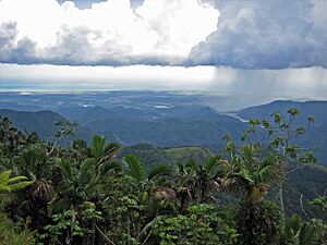
Puerto Rico's south shore, from the mountains of Jayuya, taken from Highway 143
-
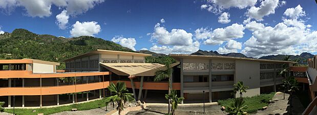
School damaged by Hurricane María in 2017
-
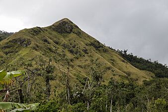
Mountain in Jayuya
-
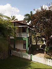
Hacienda Gripiñas in Jayuya
-
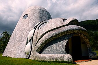
Cemi Museum in Coabey


See also
 In Spanish: Jayuya para niños
