Pica, Jayuya, Puerto Rico facts for kids
Quick facts for kids
Pica
|
|
|---|---|
|
Barrio
|
|

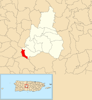
Location of Pica within the municipality of Jayuya shown in red
|
|
| Commonwealth | |
| Municipality | |
| Area | |
| • Total | 0.94 sq mi (2.4 km2) |
| • Land | 0.94 sq mi (2.4 km2) |
| • Water | 0.00 sq mi (0 km2) |
| Elevation | 2,418 ft (737 m) |
| Population
(2010)
|
|
| • Total | 153 |
| • Density | 168.8/sq mi (65.2/km2) |
| Source: 2010 Census | |
| Time zone | UTC−4 (AST) |
Pica (which means Barrio Pica in Spanish) is a small area or neighborhood called a barrio. It is located in the municipality of Jayuya, which is a town in Puerto Rico.
In 2010, about 153 people lived in Pica. This area became its own barrio in 1948. Before that, it was part of another area called Jayuya Arriba.
Population Over Time
The number of people living in Pica has changed quite a bit over the years.
| Historical population | |||
|---|---|---|---|
| Census | Pop. | %± | |
| 1950 | 179 | — | |
| 1980 | 142 | — | |
| 1990 | 303 | 113.4% | |
| 2000 | 356 | 17.5% | |
| 2010 | 153 | −57.0% | |
| U.S. Decennial Census 1950 1980-2000 2010 |
|||
For example, in 1950, there were 179 residents. By 1980, the population went down to 142 people.
However, it grew quite a lot by 2000, reaching 356 residents. Then, in 2010, the population was recorded as 153 people.
See also
 In Spanish: Pica (Jayuya) para niños
- List of communities in Puerto Rico
Black History Month on Kiddle
Distinguished African-American Artists:
 | Sharif Bey |
 | Hale Woodruff |
 | Richmond Barthé |
 | Purvis Young |

All content from Kiddle encyclopedia articles (including the article images and facts) can be freely used under Attribution-ShareAlike license, unless stated otherwise. Cite this article:
Pica, Jayuya, Puerto Rico Facts for Kids. Kiddle Encyclopedia.

