
Municipalities of Puerto Rico facts for kids
Quick facts for kids Municipalities of Puerto Rico |
|
|---|---|
 |
|
| Location | Commonwealth of Puerto Rico |
| Number | 78 |
| Populations | From 1,818 pop. in Culebra to 395,326 pop. in San Juan |
| Areas | From 4.84 square miles (12.5 km2) in Cataño to 125.95 square miles (326.2 km2) in Arecibo |
| Government | Mayor–council government |
| Subdivisions | Barrio |
The municipalities of Puerto Rico (in Spanish: municipios de Puerto Rico) are like the main local areas or "counties" of Puerto Rico. There are 78 of these areas, and they cover all the towns and cities. Each municipality has a leader called a mayor and a group of elected officials called a municipal legislature. These leaders are chosen by the people every four years.
Each municipality is also divided into smaller parts called barrios. These barrios are like neighborhoods or districts, but they don't have their own political power. The way municipalities are run is set by a law called the Autonomous Municipalities Act of 1991, which gives them more control over their own services.
Some municipalities are big cities, while others are smaller towns. If a municipality has more than 50,000 people, it's usually called a city. If it has fewer, it's called a town. Cities often manage their own services, like trash collection or public safety. Smaller towns might get some of these services from nearby cities.
For official counts, like the U.S. Census, Puerto Rico's municipalities are treated like counties in the United States. The municipality with the most people is San Juan, which is also the capital. The smallest in population is Culebra. In terms of size, Arecibo is the largest, and Cataño is the smallest.
Every municipality has a main area called pueblo or barrio-pueblo. This is usually the oldest part of the municipality, where the main government buildings and town center are located. In bigger municipalities, the main urban area might include several barrios.
Contents
How Puerto Rico's Municipalities Work
Puerto Rico used to be a Spanish territory until 1898. Because of this, its local government system is more similar to countries in Latin America than to the United States. Instead of counties, Puerto Rico has 78 municipalities as its main local government units. The U.S. Census Bureau counts these municipalities as "county equivalents."
In 1991, the Autonomous Municipalities Act was passed. This law gave Puerto Rican municipalities more rights and responsibilities. The goal was to give local areas more control and improve public services.
Almost every municipality is made up of smaller areas called barrios. The only exception is Florida, which has just one barrio. Ponce has the most barrios, with 31!
Most municipalities have a main urban area, which is often called "Barrio Pueblo" if it's just one barrio. But in larger municipalities, the urban area can be made up of many barrios. For example, Ponce's urban area includes 12 barrios. San Juan is unique because all of its barrios are urban, meaning the entire municipality is one big city area.
The 78 Municipalities
Puerto Rico is divided into 78 municipalities. Here is a list of some of them, showing their location, flags, and coats of arms:
| Municipalities of Puerto Rico | ||||||||||
|---|---|---|---|---|---|---|---|---|---|---|
| Name | Location | Flag | Coat of Arms | Title | FIPS code |
Population (2020) |
Population (2010) |
Area | Founded | Barrios |
| Adjuntas |  |
Town | 001 | 18,020 | 19,483 | 66.69 sq mi (172.73 sq km) | 1815 | List | ||
| Aguada |  |
Town | 003 | 38,136 | 41,959 | 30.85 sq mi (79.90 sq km) | 1639 | List | ||
| Aguadilla |  |
City | 005 | 55,101 | 60,949 | 36.53 sq mi (94.61 sq km) | 1775 | List | ||
| Aguas Buenas |  |
Town | 007 | 24,223 | 28,659 | 30.08 sq mi (77.92 sq km) | 1838 | List | ||
| Aibonito |  |
Town | 009 | 24,637 | 25,900 | 31.31 sq mi (81.10 sq km) | 1824 | List | ||
| Añasco |  |
Town | 011 | 25,596 | 29,261 | 39.29 sq mi (101.75 sq km) | 1733 | List | ||
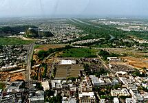
| Arecibo |  |
City | 013 | 87,754 | 96,440 | 125.95 sq mi (326.20 sq km) | 1616 | List | ||
| Arroyo |  |
Town | 015 | 15,843 | 19,575 | 15.01 sq mi (38.87 sq km) | 1855 | List | ||
| Barceloneta |  |
Town | 017 | 22,657 | 24,816 | 18.69 sq mi (48.41 sq km) | 1881 | List | ||
| Barranquitas |  |
Town | 019 | 28,983 | 30,318 | 34.25 sq mi (88.71 sq km) | 1803 | List | ||
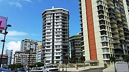
| Bayamón |  |
City | 021 | 185,187 | 208,116 | 44.32 sq mi (114.80 sq km) | 1772 | List | ||
| Cabo Rojo |  |
Town | 023 | 47,158 | 50,917 | 70.37 sq mi (182.27 sq km) | 1771 | List | ||
| Caguas |  |
City | 025 | 127,244 | 142,893 | 58.60 sq mi (151.77 sq km) | 1775 | List | ||
| Camuy |  |
Town | 027 | 32,827 | 35,159 | 46.35 sq mi (120.06 sq km) | 1807 | List | ||
| Canóvanas |  |
Town | 029 | 42,337 | 47,648 | 32.87 sq mi (85.12 sq km) | 1909 | List | ||
| Carolina |  |
City | 031 | 154,815 | 176,762 | 45.32 sq mi (117.38 sq km) | 1816 | List | ||
| Cataño | Town | 033 | 23,155 | 28,140 | 4.84 sq mi (12.55 sq km) | 1927 | List | |||
| Cayey |  |
Town | 035 | 41,652 | 48,119 | 51.93 sq mi (134.51 sq km) | 1773 | List | ||
| Ceiba |  |
Town | 037 | 11,307 | 13,631 | 29.04 sq mi (75.20 sq km) | 1838 | List | ||
| Ciales |  |
Town | 039 | 16,984 | 18,782 | 66.53 sq mi (172.31 sq km) | 1820 | List | ||
| Cidra |  |
Town | 041 | 39,970 | 43,480 | 36.02 sq mi (93.29 sq km) | 1809 | List | ||
| Coamo |  |
Town | 043 | 34,668 | 40,512 | 78.10 sq mi (202.27 sq km) | 1579 | List | ||
| Comerío |  |
Town | 045 | 18,883 | 20,778 | 28.40 sq mi (73.56 sq km) | 1826 | List | ||
| Corozal |  |
Town | 047 | 34,571 | 37,142 | 42.57 sq mi (110.26 sq km) | 1795 | List | ||
| Culebra |  |
Town | 049 | 1,792 | 1,818 | 11.62 sq mi (30.10 sq km) | 1880 | List | ||
| Dorado |  |
Town | 051 | 35,879 | 38,165 | 23.09 sq mi (59.80 sq km) | 1842 | List | ||
| Fajardo | Town | 053 | 32,124 | 36,993 | 29.86 sq mi (77.34 sq km) | 1772 | List | |||
| Florida | .svg) |
Town | 054 | 11,692 | 12,680 | 15.21 sq mi (39.39 sq km) | 1971 | List | ||
| Guánica | Town | 055 | 13,787 | 19,427 | 37.05 sq mi (95.96 sq km) | 1914 | List | |||
| Guayama |  |
Town | 057 | 36,614 | 45,362 | 64.99 sq mi (168.32 sq km) | 1736 | List | ||
| Guayanilla |  |
Town | 059 | 17,784 | 21,581 | 42.27 sq mi (109.48 sq km) | 1833 | List | ||
| Guaynabo |  |
City | 061 | 89,780 | 97,924 | 27.58 sq mi (71.43 sq km) | 1769 | List | ||
| Gurabo |  |
Town | 063 | 40,622 | 45,369 | 27.89 sq mi (72.23 sq km) | 1815 | List | ||
| Hatillo |  |
Town | 065 | 38,486 | 41,953 | 41.78 sq mi (108.21 sq km) | 1823 | List | ||
| Hormigueros |  |
Town | 067 | 15,654 | 17,250 | 11.34 sq mi (29.37 sq km) | 1874 | List | ||
| Humacao |  |
City | 069 | 50,896 | 58,466 | 44.75 sq mi (115.90 sq km) | 1722 | List | ||
| Isabela |  |
Town | 071 | 42,943 | 45,631 | 55.30 sq mi (143.23 sq km) | 1819 | List | ||
| Jayuya |  |
Town | 073 | 14,779 | 16,642 | 44.53 sq mi (115.33 sq km) | 1911 | List | ||
| Juana Díaz |  |
Town | 075 | 46,538 | 50,747 | 60.28 sq mi (156.12 sq km) | 1798 | List | ||
| Juncos | Town | 077 | 37,012 | 40,290 | 26.49 sq mi (68.61 sq km) | 1797 | List | |||
| Lajas |  |
Town | 079 | 23,334 | 25,753 | 59.95 sq mi (159.15 sq km) | 1883 | List | ||
| Lares |  |
Town | 081 | 28,105 | 30,753 | 61.45 sq mi (159.15 sq km) | 1827 | List | ||
| Las Marías |  |
Town | 083 | 8,874 | 9,881 | 46.36 sq mi (120.07 sq km) | 1871 | List | ||
| Las Piedras |  |
Town | 085 | 35,180 | 38,675 | 33.88 sq mi (87.75 sq km) | 1773 | List | ||
| Loíza |  |
Town | 087 | 23,693 | 30,060 | 19.37 sq mi (50.17 sq km) | 1719 | List | ||
| Luquillo |  |
Town | 089 | 17,781 | 20,068 | 25.81 sq mi (66.85 sq km) | 1797 | List | ||
| Manatí |  |
Town | 091 | 39,492 | 44,113 | 46.13 sq mi (119.48 sq km) | 1738 | List | ||
| Maricao |  |
Town | 093 | 4,755 | 6,276 | 36.62 sq mi (94.85 sq km) | 1874 | List | ||
| Maunabo |  |
Town | 095 | 10,589 | 12,225 | 21.07 sq mi (54.57 sq km) | 1799 | List | ||
| Mayagüez |  |
City | 097 | 73,077 | 89,080 | 77.65 sq mi (201.11 sq km) | 1760 | List | ||
| Moca |  |
Town | 099 | 37,460 | 40,109 | 50.34 sq mi (130.38 sq km) | 1772 | List | ||
| Morovis |  |
Town | 101 | 28,727 | 32,610 | 38.87 sq mi (100.67 sq km) | 1818 | List | ||
| Naguabo |  |
Town | 103 | 23,386 | 26,720 | 51.66 sq mi (133.80 sq km) | 1821 | List | ||
| Naranjito |  |
Town | 105 | 29,241 | 30,402 | 27.40 sq mi (70.97 sq km) | 1824 | List | ||
| Orocovis | Town | 107 | 21,434 | 23,423 | 63.62 sq mi (164.78 sq km) | 1825 | List | |||
| Patillas |  |
Town | 109 | 15,985 | 19,277 | 46.7 sq mi (120.95 sq km) | 1811 | List | ||
| Peñuelas |  |
Town | 111 | 20,399 | 24,282 | 44.62 sq mi (115.57 sq km) | 1793 | List | ||
| Ponce |  |
City | 113 | 137,491 | 166,327 | 114.76 sq mi (297.23 sq km) | 1692 | List | ||
| Quebradillas |  |
Town | 115 | 23,638 | 25,919 | 22.68 sq mi (58.74 sq km) | 1823 | List | ||
| Rincón | Town | 117 | 15,187 | 15,200 | 14.29 sq mi (37.01 sq km) | 1771 | List | |||
| Río Grande |  |
Town | 119 | 47,060 | 54,304 | 60.62 sq mi (157.01 sq km) | 1840 | List | ||
| Sabana Grande | Town | 121 | 22,729 | 25,265 | 35.83 sq mi (92.80 sq km) | 1813 | List | |||
| Salinas |  |
Town | 123 | 25,789 | 31,078 | 69.37 sq mi (179.67 sq km) | 1851 | List | ||
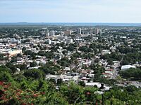
| San Germán |  |
Town | 125 | 31,879 | 35,527 | 54.50 sq mi (141.15 sq km) | 1573 | List | ||
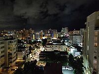
| San Juan |  |
City | 127 | 342,259 | 395,326 | 47.85 sq mi (123.93 sq km) | 1519 | List | ||
| San Lorenzo |  |
Town | 129 | 37,693 | 41,058 | 53.11 sq mi (137.55 sq km) | 1811 | List | ||
| San Sebastián |  |
Town | 131 | 39,345 | 42,430 | 70.42 sq mi (182.39 sq km) | 1752 | List | ||
| Santa Isabel |  |
Town | 133 | 20,281 | 23,274 | 34.02 sq mi (88.119 sq km) | 1842 | List | ||
| Toa Alta |  |
City | 135 | 66,852 | 74,066 | 27.02 sq mi (69.98 sq km) | 1751 | List | ||
| Toa Baja |  |
City | 137 | 75,293 | 89,609 | 23.24 sq mi (60.19 sq km) | 1745 | List | ||
| Trujillo Alto |  |
City | 139 | 67,740 | 74,842 | 20.76 sq mi (53.77 sq km) | 1801 | List | ||
| Utuado |  |
Town | 141 | 28,287 | 33,149 | 113.53 sq mi (294.04 sq km) | 1739 | List | ||
| Vega Alta |  |
Town | 143 | 35,395 | 39,951 | 27.73 sq mi (71.82 sq km) | 1775 | List | ||
| Vega Baja |  |
City | 145 | 54,414 | 59,662 | 45.86 sq mi (118.78 sq km) | 1776 | List | ||
| Vieques |  |
Town | 147 | 8,249 | 9,301 | 50.77 sq mi (131.49 sq km) | 1852 | List | ||
| Villalba |  |
Town | 149 | 22,093 | 26,073 | 35.64 sq mi (92.31 sq km) | 1917 | List | ||
| Yabucoa |  |
Town | 151 | 30,412 | 37,941 | 55.21 sq mi (142.99 sq km) | 1793 | List | ||
| Yauco |  |
Town | 153 | 34,172 | 42,043 | 68.19 sq mi (176.61 sq km) | 1756 | List | ||
Puerto Rico's Largest Municipalities by Population
Here are the municipalities with the most people:
- Municipalities with more than 100,000 inhabitants
-
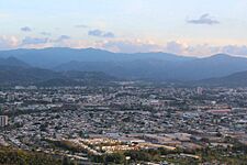
San Juan, the largest municipality and capital of Puerto Rico.
-
Bayamón, the second largest municipality of Puerto Rico, located just west of San Juan.
-
Carolina, the third largest municipality of Puerto Rico, located just east of San Juan.
-
Ponce, the fourth largest municipality of Puerto Rico and the largest municipality outside the San Juan metropolitan area.
-
Caguas, the fifth largest municipality of Puerto Rico.


Money Matters: How Municipalities Handle Their Budgets
In 2012, about half of Puerto Rico's 78 municipalities (36 of them) were spending more money than they were taking in. This is called a budget deficit. Together, all the municipalities owed about $590 million.
Some municipalities had a surplus, meaning they had extra money. Others had a deficit, meaning they were short on money. For example, Aguadilla had a large surplus of over $10 million, while San Juan had a deficit of over $45 million.
Ideas for Changing Municipalities
Over the years, people have suggested combining some of Puerto Rico's municipalities to make them more efficient. So far, none of these ideas have become law.
- In 1902, a law was passed to reduce the number of municipalities from 76 to 46. But this law was canceled just three years later.
- In 2009, a politician suggested a plan to cut the 78 municipalities down to 20. This idea was supposed to be voted on by the public, but it never happened.
- More recently, around 2017, when Puerto Rico faced a big government debt problem, the idea of combining municipalities came up again. The goal was to save money and help with the debt.
- In 2019, Governor Ricardo Rosselló had a plan to keep all the municipalities but have them share services in bigger regional groups, similar to counties. However, he resigned before this plan could move forward.
See also
 In Spanish: Anexo:Municipios de Puerto Rico para niños
