
Isabela, Puerto Rico facts for kids
Quick facts for kids
Isabela
Municipio de Isabela
|
|||
|---|---|---|---|
|
Town and Municipality
|
|||

Aerial view of Isabela and its coastline
|
|||
|
|||
| Nicknames:
"El Jardín del Noroeste", "El Pueblo de los Quesitos de Hoja"
|
|||
| Anthem: "Isabela – Danza " | |||

Map of Puerto Rico highlighting Isabela Municipality
|
|||
| Sovereign state | |||
| Commonwealth | |||
| Settled | 1720–1725 | ||
| Founded | May 21, 1819 | ||
| Founded by | Manuel Corchado y Juarbe | ||
| Named for | Isabella I of Castile | ||
| Barrios | |||
| Area | |||
| • Total | 91.95 sq mi (238.15 km2) | ||
| • Land | 55.36 sq mi (143.39 km2) | ||
| • Water | 36.58 sq mi (94.75 km2) | ||
| Population
(2020)
|
|||
| • Total | 42,943 | ||
| • Rank | 18th in Puerto Rico | ||
| • Density | 467.024/sq mi (180.319/km2) | ||
| Demonym(s) | Isabelinos | ||
| Time zone | UTC−4 (AST) | ||
| ZIP Code |
00662
|
||
| Area code(s) | 787/939 | ||
| Major routes | |||
| Website | https://venaisabela.com/ | ||


Isabela (pronounced isa-ˈβela) is a fun town and municipality in Puerto Rico. It's located on the northwest coast of the island. You'll find it north of San Sebastián, west of Quebradillas, and east of Aguadilla and Moca. The town is named after Queen Isabella I of Castile from Spain. Isabela is divided into 13 areas called barrios, plus the downtown area known as Isabela Pueblo. It's a key part of the larger Aguadilla-Isabela-San Sebastián Metropolitan Statistical Area.
Contents
- Discovering Isabela: Fun Nicknames
- Isabela's Past: A Brief History
- Isabela's People: Population Facts
- Isabela's Landscape: Geography and Nature
- Isabela's Economy: How People Make a Living
- Isabela's Culture: Festivals and Sports
- Exploring Isabela: Tourism and Landmarks
- Isabela's Symbols: Flag and Coat of Arms
- Famous People from Isabela
- Images for kids
- See also
Discovering Isabela: Fun Nicknames
Isabela has some cool nicknames! It's called the Jardín del Noroeste which means "Garden of the Northwest." This is because of all the beautiful wild flowers that grow there.
It's also known as El Pueblo de los Quesitos de Hoja, or "Town of Leaf Cheeses." This name comes from a special fresh white cheese made there. This cheese is wrapped in banana leaves and is said to be the best!
Another nickname is la Ciudad de los Gallitos, meaning the "City of the Fighting Cocks." For a long time, cock fighting was popular on the island. Isabela became famous for its strong fighting cocks and the special ways people raised and trained them.
Isabela's Past: A Brief History
The area where Isabela is located was once ruled by a chief named Mabodamaca. He was an important leader of the Taíno people, who were the first inhabitants of Puerto Rico.
The first Spanish settlement here started around the early 1700s. It was a small village called San Antonio de La Tuna. This name came from a saint, Anthony of Padua, and a wild cactus plant called 'Tuna' in Spanish. By the late 1700s, this village had a church and almost 1,200 people.
Around 1818, the people decided to move the village closer to the coast. This new location was better for health and trade. So, on May 21, 1819, the new town of Isabela was officially founded. The church was built soon after.
After the Spanish–American War in 1898, Puerto Rico became a territory of the United States. In 1899, a count of the population showed that Isabela had 14,888 people.
More recently, in September 2017, Hurricane Maria hit Puerto Rico. Isabela faced a lot of damage to homes and buildings. The hurricane also damaged the nearby Guajataca Reservoir, causing thousands of people to leave their homes for safety.
Isabela's People: Population Facts
| Historical population | |||
|---|---|---|---|
| Census | Pop. | %± | |
| 1900 | 14,888 | — | |
| 1910 | 16,852 | 13.2% | |
| 1920 | 19,809 | 17.5% | |
| 1930 | 23,068 | 16.5% | |
| 1940 | 25,842 | 12.0% | |
| 1950 | 29,113 | 12.7% | |
| 1960 | 28,754 | −1.2% | |
| 1970 | 30,430 | 5.8% | |
| 1980 | 37,435 | 23.0% | |
| 1990 | 39,147 | 4.6% | |
| 2000 | 44,444 | 13.5% | |
| 2010 | 45,631 | 2.7% | |
| 2020 | 42,943 | −5.9% | |
| 2022 (est.) | 42,754 | −6.3% | |
| U.S. Decennial Census 1899 (shown as 1900) 1910–1930 1930–1950 1960–2000 2010 2020 |
|||
In 2010, Isabela had 45,631 residents. This was a small increase from the year 2000. By 2020, the population was 42,943. People from Isabela are called Isabelinos.
Isabela's Landscape: Geography and Nature
Isabela is a unique town because it has both beautiful beaches and mountains. Some mountain peaks are over 1,000 feet (300 meters) high! It also has rivers, lakes, caves, cliffs, and forests, including mangroves.
The town is part of Puerto Rico's Northern Coastal Plains. The Aymamón Mountains run through the south, with hills like La Bandera and La Silla. The central part of Isabela is mostly flat land.
Isabela's Neighborhoods: Barrios

Like all towns in Puerto Rico, Isabela is divided into smaller areas called barrios. The main town center, with its municipal buildings and Catholic church, is known as "el pueblo".
Here are the barrios of Isabela:
- Arenales Altos
- Arenales Bajos
- Bajura
- Bejucos
- Coto
- Galateo Alto
- Galateo Bajo
- Guayabos
- Guerrero
- Isabela barrio-pueblo
- Jobos
- Llanadas
- Mora
- Planas
Isabela's Economy: How People Make a Living
In the early days, Isabela's economy relied on raising cattle and hogs. Trading was difficult because the first settlement was far from the coast.
When the town moved to its current location, things changed. Being closer to the sea and having open plains helped the economy grow. People started growing sugarcane, coffee, tobacco, cotton, and fruits like coconut. This helped Isabela become a busy and successful town.
Today, Isabela also has modern industries. It has a high-tech factory, a university, a famous agricultural research center, and a large shopping mall called Plaza Isabela.
Isabela's Culture: Festivals and Sports
Isabela is a lively place with many festivals and events throughout the year.
Festivals and Events in Isabela
Isabela celebrates its main festival, the Fiestas Patronales de San Antonio de Padua, in June. This is a religious and cultural event with parades, games, local crafts, fun rides, delicious food, and live music.
Other exciting events include:
- Three Kings Day – January
- Isabela Cock Fight Festival – February
- Textile Festival – May
- Puerto Rock Steady Music Festival – May
- Weave Festival – May
- Kite Festival – May
- Isabela Muscle Cars Auto Show – August
- Isabela International Tango Festival – August
- Classic and Old Car Exhibition – November
- Isabela Has Flavor – November
- Holy Innocents' Day – December
Sports and Recreation in Isabela
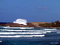
Isabela is famous for its amazing surfing spots. It has even hosted big surfing competitions like the World Cup Surfing Championships!
The town used to have a basketball team called the Isabela Roosters (Gallitos de Isabela). They played at the Jose "Buga" Abreu Coliseum and were very good in the 1970s and 1980s.
Isabela also has a female volleyball team called the Playeras. The Isabela Muscle Cars Club holds popular annual events, showcasing classic cars.
The town is also known for its beautiful Fine Step Horses (Caballos de Paso Fino).
Exploring Isabela: Tourism and Landmarks


Isabela is a great place for tourists! The Puerto Rico Tourism Company promotes it with a campaign called Voy Turistiendo ("I'm Touring"). Some popular spots include Playa Montones, Tunel de Guajataca, and Mabodamaca.
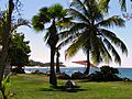
Isabela has 12 beaches, including the well-known Jobos Beach.
Top Landmarks and Places to Visit
- El Pozo Brujo (The Bewitched Well)
- Jobos Beach
- Pozo de Jacinto
- Montones Beach
- San Antonio de la Tuna Ruins
- Punta Sardina
- La Princesa Beach & Blow Hole
- Villa Pesquera
- Río Guajataca
- Guajataca Tunnel
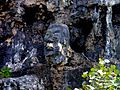
- La Cara del Indio (The Indian's Face)
- Middles Beach
- San Antonio de la Tuna Museum
- La Pocita de Isabela
- La Cueva de las Golondrinas
- Cueva los Vientos (Guajataca Forest)
- Photo Museum of Isabela
- Bajura Beach (also known as Shacks Beach)
Isabela's Symbols: Flag and Coat of Arms
The town of Isabela has its own official flag and coat of arms.
Isabela's Flag
Isabela's flag gets its design and colors from its coat of arms. It has three equal horizontal stripes. The top and bottom stripes are yellow, and the middle one is green. Sometimes, the coat of arms is placed in the center of the green stripe.
Isabela's Coat of Arms
The town's coat of arms was created in 1819. It features an olive tree in the middle, which represents the first people of Isabela and Puerto Rico, the Igneris Indians. The gold color stands for the Taíno Indians, who used a lot of gold.
A gold bell between two cactus plants symbolizes the old town of San Antonio de la Tuna. The two roosters show the bravery of the people and Isabela's famous fighting cocks. A horse represents the region's cattle and honors the special fine step horses (Paso Fino) that Isabela is known for.
The coat of arms has a mural crown on top. This crown used to have three towers, which was a symbol for towns under Spanish rule. Now, it has five towers to show that Isabela has grown into a city, as it has more than 50,000 residents.
Famous People from Isabela
- Félix Mantilla (baseball): A former All-Star baseball player who won the World Series.
- Víctor Manuelle: A world-famous salsa singer whose parents are from Isabela. He often shows his hometown in his music videos.
- Manuel Corchado y Juarbe: A poet, journalist, and politician who fought to end slavery and create a university in Puerto Rico.
- Noel Epinanio Estrada Suárez: A famous composer who wrote "En mi Viejo San Juan", a song known worldwide.
- Vicente Geigel Polanco: A lawyer, writer, and former Attorney General of Puerto Rico.
Images for kids
-
Beach in Isabela
-
Villa Montaña Beach Resort
-
Guajataca State Forest
-
La cara del indio

.jpg)

.jpg)
See also
 In Spanish: Isabela (Puerto Rico) para niños
