
Aguadilla, Puerto Rico facts for kids
Quick facts for kids
Aguadilla
San Carlos de la Aguadilla
|
|||
|---|---|---|---|

Aerial View of Downtown Aguadilla
|
|||
|
|||
| Nicknames:
Jardín del Atlántico, La Villa del Ojo de Agua, El Pueblo de los Tiburones
|
|||
| Anthem: Playita Aguadillana | |||

Map of Puerto Rico highlighting Aguadilla Municipality
|
|||
| Sovereign state | |||
| Commonwealth | |||
| First settled | 16th century | ||
| Founded | July 6, 1775 | ||
| Founded by | Luis de Córdova | ||
| Barrios | |||
| Area | |||
| • Municipality | 76.3 sq mi (198 km2) | ||
| • Land | 36.6 sq mi (95 km2) | ||
| • Water | 39.0 sq mi (101 km2) 51% | ||
| Elevation | 326 ft (99 m) | ||
| Population
(2020)
|
|||
| • Municipality | 55,101 | ||
| • Rank | 12th in Puerto Rico | ||
| • Density | 722.2/sq mi (278.83/km2) | ||
| • Metro | 310,160 (MSA) | ||
| Demonym(s) | Aguadillanos | ||
| Racial groups | |||
| • 2020 Census | 48.1% Multiracial 21.0% White 4.1% Black 0.5% American Ind/AN 0.1% Asian 26.2% Other |
||
| Time zone | UTC−4 (AST) | ||
| ZIP Codes |
00603, 00604, 00605, 00690
|
||
| Area code(s) | 787/939 | ||
| Major routes | |||
| Website | aguadilla.gobierno.pr | ||


Aguadilla is a city and municipality located on the northwestern tip of Puerto Rico. It was founded in 1775 by Luis de Córdova. The city is bordered by the Atlantic Ocean to the north and west. It is north of Aguada, and Moca, and west of Isabela.
Aguadilla is divided into 15 barrios (neighborhoods) and Aguadilla Pueblo, which is the downtown area and the city's main center. It is a key city in the Aguadilla-Isabela-San Sebastián Metropolitan Statistical Area. Even though it was known as Aguadilla before 1770, it was officially founded in 1780.
Contents
- What's in a Name? Etymology and Nicknames
- A Look Back: Aguadilla's History
- Where is Aguadilla? Geography
- How Aguadilla Makes Money: Economy
- Culture and Fun
- Staying Connected: Communication
- Who Lives Here? Demographics
- City Symbols
- Learning in Aguadilla: Education
- Getting Around: Transportation
- Notable people from Aguadilla
- Images for kids
- See Also
What's in a Name? Etymology and Nicknames

The name Aguadilla is a shorter version of its original name, San Carlos de La Aguadilla. It's also a smaller version of Aguada, a nearby town to the south.
Aguadilla has several cool nicknames:
- Jardín del Atlántico means "Garden of the Atlantic".
- Pueblo de los Tiburones means "Shark Town".
- La Villa del Ojo de Agua means "Villa of the Water Spring". This nickname comes from a natural water spring in El Parterre Square that early settlers and Spanish soldiers used for water.
A Look Back: Aguadilla's History
Early Settlements and Founding
Long ago, a Taíno settlement called Aymamón existed near the Culebrinas River. Aguadilla was originally part of the Aguada territory. People wanted their own town as early as 1736.
In 1770, a small chapel was built. In 1775, Luis de Córdova approved the founding of Aguadilla. Bernardo Sosa became the town's first mayor. A larger church started being built. In 1776, a writer named Fray Íñigo Abbad y Lasierra called it the "new Town of San Carlos de La Aguadilla."
The town officially separated in 1780. Aguadilla grew quickly because it had an excellent port. Many people from Santo Domingo moved to Aguadilla in 1776, helping its population grow even more.
The 1800s: Becoming a Loyal Village
The early 1800s brought challenges. A big fire destroyed many homes. In 1825, Hurricane Santa Ana ruined most of Aguadilla's orange farms.
By 1831, Aguadilla was part of Aguada. Its areas included places like Montaña, Borinquen, and Victoria. Aguadilla's port was very important for ships traveling between Europe, Havana, and Mexico.
In 1860, Queen Isabela II officially declared Aguadilla a "loyal village" (villa leal). This gave the town special benefits. Later, Aguadilla became the main city for a large region that included other towns like Isabela and Moca.
In 1893, Hurricane San Roque damaged farms and homes.
After the Spanish-American War

After Puerto Rico became part of the United States in 1898, Aguadilla's areas stayed mostly the same. More natural disasters hit the town. In 1899, Hurricane San Ciriaco caused a lot of damage.
The 1918 San Fermín earthquake and the giant wave (tsunami) that followed also hit Aguadilla hard. Forty people died, and many buildings were damaged or destroyed. A community called San Antonio was completely wiped out by the tsunami. Its residents then moved to a higher area away from the coast.
New things came to Aguadilla, like the first theaters, a social club, and a new school system. A bakery and a post office also opened. The clothing industry became a big source of jobs.

In 1944, Puerto Rico had its worst train accident near Aguadilla. A train carrying many passengers derailed on a hill called Cuesta Vieja. The engine exploded, and cars crashed, causing a sad event. Sixteen people died, and 50 were hurt.

In 1948, the downtown area of Aguadilla grew to include parts of other neighborhoods. There was also a disagreement with Aguada about who owned a park called Parque Colón. After looking at old maps and documents, it was decided that Parque Colón belonged to Aguadilla.
The Cold War Era

In 1939, a large area of land was taken to build an air base called Ramey Air Force Base. Aguadilla was home to this important military base for almost 50 years. During the Cold War, Ramey Air Force Base was a key location for the United States military. It housed large bombers like the B-52s.
The town's center was updated, and a new plaza opened in 1955. In 1971, Aguadilla became part of a new Senatorial District. In 1979, a factory that made airplane parts opened at the base.
Even though the military base is no longer fully active, its buildings are still used. The airport is now the Rafael Hernández International Airport. Old barracks are now a hotel, and the Officer's Club is a meeting center. The former hospital is now a hotel and casino.
The area that used to be Ramey Air Force Base also has the University of Puerto Rico at Aguadilla and other schools. There is still a part of the base used by the Coast Guard and other government agencies.
Recent Times: 21st Century and Hurricane Maria
.jpg)
Hurricane Maria hit Puerto Rico on September 20, 2017. It caused a lot of damage to buildings and power lines in Aguadilla. The city's more than 54,000 residents lost electricity.
The four radar systems used by the Federal Aviation Administration for flights around Puerto Rico were damaged. One of these radar systems is in Aguadilla. It took almost two weeks to fix them.
The 2020s
In recent years, Aguadilla gained some international attention. A video of an Unidentified Anomalous Phenomena (UAP) was filmed by a Customs and Patrol aircraft near Rafael Hernández Airport in 2013. The video, sometimes called “The Aguadilla UFO Incident,” shows a glowing object flying near the airport. It has been shown on TV shows about unexplained phenomena.
In 2024, the local government filed a lawsuit against LUMA Energy. This was due to problems with the energy distribution system.
Where is Aguadilla? Geography
Aguadilla is on the northwest coast of Puerto Rico. It is part of the Western Coastal Plains. The Atlantic Ocean is to its north. Isabela is to the east, and Moca and Aguada are to the south.
The municipality covers about 35.5 square miles. It is mostly flat, but has some hills like Jiménez (728 feet) and Viñet (689 feet). The Culebrinas River is its only river, separating Aguadilla from Aguada. Cedro Creek separates Aguadilla from Isabela in the north.
Barrios: Aguadilla's Neighborhoods

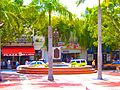
Like all towns in Puerto Rico, Aguadilla is divided into barrios (neighborhoods). The main government buildings and the big Catholic church are in the downtown area, called Aguadilla Pueblo.
Sectors: Smaller Areas

Barrios are further divided into smaller areas called sectores. These can be called urbanización, reparto, or barriada.
Special Communities
Comunidades Especiales de Puerto Rico (Special Communities of Puerto Rico) are neighborhoods where people face challenges. In Aguadilla, these include El Palmar, Cerro Calero, Cerro Visbal, Cuesta Vieja, La Vía, and Poblado San Antonio.
Ocean Temperature
| Jan | Feb | Mar | Apr | May | Jun | Jul | Aug | Sep | Oct | Nov | Dec | Year |
|---|---|---|---|---|---|---|---|---|---|---|---|---|
| 77 °F (25 °C) | 75 °F (24 °C) | 77 °F (25 °C) | 77 °F (25 °C) | 79 °F (26 °C) | 81 °F (27 °C) | 84 °F (29 °C) | 84 °F (29 °C) | 86 °F (30 °C) | 84 °F (29 °C) | 82 °F (28 °C) | 79 °F (26 °C) | 78.8 °F (26.0 °C) |
How Aguadilla Makes Money: Economy

Aguadilla has many factories that make things like medicine and electronics. Some big companies here are LifeScan, Honeywell, and Hewlett Packard Enterprise. These are mostly in the San Antonio Technological Park. Lufthansa Technik is at the airport. Other companies like Suiza Dairy and Lockheed Martin are in the Camaseyes Industrial Park. Aguadilla also has industries that work with rubber, plastics, leather, and food.
Shopping is also a big part of Aguadilla's economy. There are several shopping malls like Aguadilla Mall and Aguadilla Town Center.

In 2018, Suiza Dairy, a milk company, opened a new plant in Aguadilla. This plant cost $40 million and is expected to make a lot of money over the years.
In 2019, Aguadilla won the City Livability Award. This award recognized the "Pintalto" project. In this project, the Cerro Cabrero area in downtown Aguadilla was painted with bright, lively colors.
Fun Things to Do: Tourism

Aguadilla is part of the Porta del Sol tourist area in Puerto Rico. The Porta del Sol website says Aguadilla's beaches are great for surfing.
The Puerto Rico Department of Natural and Environmental Resources says Aguadilla has the most beaches on the island, with 19 in total. Some beaches are known as the best for surfing, like Surfer's Beach, Gas Chambers, and Crash Boat. Because of this, Aguadilla has hosted surfing competitions.
Other fun places to visit are Las Cascadas Water Park and the Aguadilla Ice Skating Arena. The ice skating arena is the only one in the Caribbean.
Cool Places to See: Landmarks and Places of Interest
There are nine places in Aguadilla that are listed on the US National Register of Historic Places. This means they are important historical sites.
- Old Urban Cemetery
- Casa de Piedra
- District Courthouse (Aguadilla, Puerto Rico)
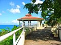
- El Parterre, Ojo de Agua
- Punta Borinquen Light
- Fuerte de la Concepción
- Iglesia de San Carlos Borromeo – Church San Carlos Borromeo
- Cardona Residence
- López Residence
Other interesting places in Aguadilla include:
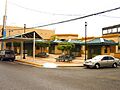
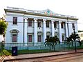
- Aguadilla City Hall – built in 1918, rebuilt after the 1918 earthquake.
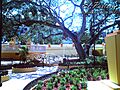
- Banyan Treehouse – a wooden house built around a banyan tree.
- Campanitas de Cristal, a fountain.
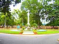
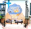
- Christopher Columbus Monument – a cross monument.
- Parque Cristóbal Colón, a park.
- El Merendero
- Fisherman's Monument.
- Jardín del Atlántico, a square.
- Las Cascadas (The Waterfalls) Water Park (Closed after Hurricane Maria in 2017).
- Old Sugar Pier of Aguadilla.
- Paseo Miguel Garcia Méndez.
- Punta Borinquen Golf Course – an 18-hole golf course.
- Punta Borinquen Lighthouse and its old ruins.
- Rafael Hernández Monument.
- Rafael Hernández Square.
- Ramey Skate Park, a skatepark at the Ramey Military Base.
- Youth Fountain at Juan Ponce de León Park.
To encourage local tourism, the Puerto Rico Tourism Company started the Voy Turistiendo ("I'm Touring") campaign in 2021. The Aguadilla page in their passport book lists Crash Boat Beach, Survival Beach, Rompeolas Beach, and Peña Blanca Beach as places to visit.
Beautiful Beaches

Aguadilla has 32 beaches. Some of the most famous ones are:
- Balneario Municipal de Aguadilla
- Playa La Ruina (also called Wilderness Beach or Las Ruinas)
- Playa Punta Borinquen
- Crash Boat Beach
- Survival Beach
- Surfer's Beach
- Rompeolas Beach / Rompeolas Beach North (also known as Playa Tamarindo)
Culture and Fun
Festivals and Events
Aguadilla celebrates its patron saint festival in October. The Fiestas Patronales de San Carlos Borromeo is a religious and cultural celebration. It usually has parades, games, local crafts, rides, food, and live music.
Other festivals and events in Aguadilla include:
- Velorio de Reyes – Celebrated in January, it's a religious ceremony to thank the Three Kings.
- Kite Festival – Held in April, with kiosks, music, and kite flying.
- Fiestas San Antonio – April
- Verbena de Corrales – May
- Beach Festival – June
- Festival del Atún – A festival in July dedicated to tuna fishing.
- Festival de la Música – July
Sports Teams
Aguadilla has several sports teams. The Aguadilla Divas play volleyball in the Female Superior Volleyball League. The Aguadilla Sharks play baseball in the Superior Baseball League. The Divas play at the Luis T. Díaz Coliseum, and the Sharks play at Luis A. Canena Márquez Stadium.
| Club | League | Sport | Venue |
|---|---|---|---|
| Aguadilla Sharks | Superior Baseball League | Baseball | Luis A. Canena Márquez Stadium |
| Aguadilla Divas | Female Superior Volleyball League | Volleyball | Luis T. Diaz Coliseum |
Aguadilla also used to have a professional basketball team called the Aguadilla Sharks. Many famous baseball players come from Aguadilla.
Staying Connected: Communication
Radio Stations
- WABA La Grande 850AM
- WWNA Radio Una 1340AM
- WVOZ WAPA Radio frequency 1580AM
Television Channels
- WOLE-TV 12
- WELU (religious broadcasts)
- WSJP-LD CW 18 (a CW Television Network station)
Who Lives Here? Demographics
| Historical population | |||
|---|---|---|---|
| Census | Pop. | %± | |
| 1900 | 17,830 | — | |
| 1910 | 21,419 | 20.1% | |
| 1920 | 24,287 | 13.4% | |
| 1930 | 28,319 | 16.6% | |
| 1940 | 34,956 | 23.4% | |
| 1950 | 44,357 | 26.9% | |
| 1960 | 47,864 | 7.9% | |
| 1970 | 51,355 | 7.3% | |
| 1980 | 54,606 | 6.3% | |
| 1990 | 59,335 | 8.7% | |
| 2000 | 64,685 | 9.0% | |
| 2010 | 60,949 | −5.8% | |
| 2020 | 55,101 | −9.6% | |
| U.S. Decennial Census 1899 (shown as 1900) 1910–1930 1930–1950 1960–2000 2010 2020 |
|||
In 1887, Aguadilla had 16,140 people. The 2010 US Census showed 60,949 people living in the city. By 2020, the population was 55,101.
Most people in Puerto Rico are of Spanish or European descent. In Aguadilla, about 83.6% of people identify as having Spanish or white origin. There are also people of black, Amerindian, Asian, and other backgrounds.
Religion
Most people in Aguadilla are Christian, mainly Roman Catholic. The Catholic church is in the main square downtown. There are also many Jehovah's Witnesses and Protestants, including Pentecostals and Adventists.
Aguadilla also has an Islamic community with an Islamic Center in the Palmar neighborhood.
City Symbols
Aguadilla has an official flag and a coat of arms.
Flag
The flag has two equal horizontal stripes. The top stripe is blue, and the bottom stripe is gold. These colors are also found in the city's shield, which is in the middle of the flag.
Coat of Arms
The coat of arms was designed by Alberto Vadi. It was approved by the city in 1972.
Learning in Aguadilla: Education
Public Schools
The Puerto Rico Department of Education manages public schools. Aguadilla has the Head Start Program for several nearby towns. It also has many private schools.
Here are some public schools in Aguadilla (as of 2018-2019):
- Ana M. Javariz (elementary, K-6)
- Antonio Badillo Hernández (elementary, K-6)
- Homero Rivera Sola (elementary, K-6)
- José de Diego (elementary, K-6)
- Luis Muñoz Rivera (elementary, K-6)
- Antonio Badillo Hernandez (middle school, 7-9)
- Ester Feliciano Mendoza (middle school, 6-8)
- Benito Cerezo Vázquez (high school, 10-12)
- Juan Suárez Pelegrina (high school, 10-12)
- Salvador Fuentes (high school, 10-12)
- Centro de Adiestramiento y Bellas Artes (CABA) – a public arts school (7-12)
- Su Conchita Igartua de Suárez (elementary, PreK-8)
Higher Education
Aguadilla is home to several universities and colleges:
- Puerto Rico Aviation Maintenance Institute
- Aeronautical and Aerospace Institute of Puerto Rico (AAIPR)
- University of Puerto Rico at Aguadilla
- Metropolitan University, Aguadilla Campus
- Interamerican University of Puerto Rico, Aguadilla Campus
- Automeca Technical College
- Puerto Rico Criminal Justice College, Aguadilla Campus (Puerto Rico Police Academy)
Libraries
There is a digital library in San Antonio Village and another in downtown Aguadilla.
Getting Around: Transportation

Air Travel
Rafael Hernández Airport is in Aguadilla. It has become an important international airport for Puerto Rico, with flights to the US.
Roads
PR-2 (Rafael Henández Highway) is a major road. There are plans for a new expressway that will connect to Puerto Rico Highway 22.
Aguadilla has 13 bridges.
Notable people from Aguadilla
Images for kids
-
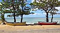
Near Schoolyards Beach
-
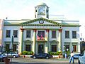
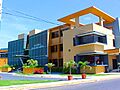
Aguadilla City Hall
-
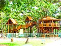
Banyan Treehouse
-
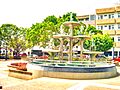
Campanitas de Cristal Fountain
-
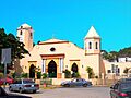
Roman Catholic Parish Church San Carlos Borromeo
-
Columbus Cross
-
El Merendero
-
El Parterre
-
Fisherman's Monument
-
Jardín del Atlántico Sq.
-
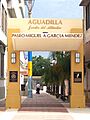
Paseo Miguel García Méndez
-
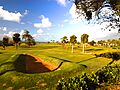
Punta Borinquen Golf Course
-
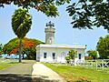
Punta Borinquen Lighthouse
-
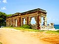
Punta Borinquen Lighthouse Ruins
-
Rafael Hernández Monument
-
Old Courthouse
-
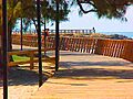
Boardwalk
-
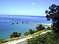
Crash Boat Beach
-
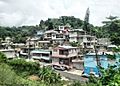
Cerro Echevarría Sector, Aguadilla barrio-pueblo
-
Aguadilla Ice Skating Arena


See Also
 In Spanish: Aguadilla para niños
