
Aguada, Puerto Rico facts for kids
Quick facts for kids
Aguada
Municipio de Aguada
|
|||
|---|---|---|---|
|
Town and Municipality
|
|||
|
From top, left to right: Main plaza and Iglesia San Francisco de Asís de la Aguada (Church of San Francisco de Asís); Ismael "Chavalillo" Delgado Aguada Multi-use Coliseum; Hacienda Caño Las Nasas (Caño Las Nasas Plantation) and Coloso sugarmill; and panoramic shoreline view
|
|||
|
|||
| Nicknames: | |||
| Anthem: "Muchos siglos han pasado" | |||

Map of Puerto Rico highlighting Aguada Municipality
|
|||
| Sovereign state | |||
| Commonwealth | |||
| First settled | May 20, 1510 | ||
| Founded | July 8, 1639 | ||
| Founded by | Don Cristóbal de Sotomayor | ||
| Barrios |
18 barrios
Aguada pueblo
Asomante Atalaya Carrizal Cerro Gordo Cruces Espinar Guanábano Guaniquilla Guayabo Jagüey Lagunas Mal Paso Mamey Marías Naranjo Piedras Blancas Río Grande |
||
| Area | |||
| • Total | 45.55 sq mi (118.0 km2) | ||
| • Land | 30.93 sq mi (80.1 km2) | ||
| • Water | 14.62 sq mi (37.9 km2) 32% | ||
| Population
(2020)
|
|||
| • Total | 38,136 | ||
| • Rank | 26th in the Puerto Rico | ||
| • Density | 837.23/sq mi (323.26/km2) | ||
| Demonym(s) | Aguadeños | ||
| Time zone | UTC−4 (AST) | ||
| ZIP Code |
00602
|
||
| Area code(s) | 787/939 | ||
| Major routes | |||


.svg)

Aguada is a town and municipality in Puerto Rico. It is located on the northwestern coast, right by the Atlantic Ocean. To its east is Moca, to its south are Añasco and Mayagüez, and to its west is Rincón. Aguada is part of a larger metropolitan area that includes Aguadilla and San Sebastián. The town's population lives across 17 areas called barrios, plus the main downtown area known as Aguada Pueblo.
| Top - 0-9 A B C D E F G H I J K L M N O P Q R S T U V W X Y Z |
What's in a Name? Aguada's Nicknames
The name Aguada is a shorter version of its original name, San Francisco de Asís de la Aguada. The word aguada means "watery" in Spanish. This might refer to the town's important location as a port. Ships could stop here to get fresh water.
Aguada has many cool nicknames:
- "La Villa de Sotomayor" (Sotomayor's Village) is named after Cristóbal de Sotomayor, one of the Spanish founders.
- "La Ciudad del Descubrimiento" (City of the Discovery) comes from the idea that Christopher Columbus might have first landed in Puerto Rico here.
- "El Pueblo Playero" means "the beach town," which makes sense because it has many beaches.
- "La Ciudad del Vaticano" (the Vatican's City) refers to how important the town was for the Catholic Church in Puerto Rico a long time ago.
Aguada's Past: A Journey Through Time
Early History and Columbus's Arrival
Long ago, a Taíno village called Aymamón was located near the Culebrinas River. Many people believe that Christopher Columbus first landed in Puerto Rico in Aguada. This happened during his second trip on November 19, 1493. However, some historians think he landed in the nearby town of Añasco.
Spanish Settlement and Challenges
In July 1510, a Spanish leader named Cristóbal de Sotomayor took control of the area. He named the town Villa de Sotomayor. But in 1511, the local Taínos attacked and burned the settlement.
Later that year, the Spanish government ordered a monastery to be built. It was called Ermita de Espinar. The area's name changed to San Francisco de Asís de la Aguada because the monks were Franciscan. The monastery was finished in 1516.
In 1526, King Charles I of Spain officially started the Aguada settlement. But in 1529, Taínos attacked the monastery again. They killed the monks and burned the settlement. The Taínos, who were the native people of Puerto Rico, had their own beliefs. The Spanish wanted them to become Catholic. In 1579, the Taínos destroyed a church and killed five Franciscans.
Growth and Disasters
Despite these challenges, Aguada grew. It became an important stop for ships traveling from South America to Spain. In 1692, the King of Spain officially declared Aguada a "village."
In 1737, King Philip V said that all mail going to Venezuela and other South American countries from Puerto Rico should leave from Aguada's ports. This helped the town's economy grow.
After the Spanish–American War in 1898, Puerto Rico became a territory of the United States. In 1899, Aguada had a population of 10,581 people.
The early 1900s brought two big disasters. In 1912, a huge fire destroyed most of the town's buildings. This included the old city hall, where all the town's important papers were kept. On October 11, 1918, a strong earthquake, known as the San Fermín earthquake, destroyed the church and other buildings.
More recently, Hurricane Maria hit Aguada on September 20, 2017. It caused many landslides and damaged or destroyed about 8,000 homes. Two police officers sadly died in the flooded Culebrinas River. On July 16, 2023, a tornado also touched down in Aguada, damaging homes and power lines.
Aguada's Shark Killer: A Local Legend

There's a cool old story from Aguada called El Matador de Tiburones (The Aguada Shark Killer). It was written around 1640. The story is about a young man who used to fight sharks. One day, he was asked to show his skills to some important Spanish visitors. But he didn't have his special good luck charm. He wondered if he could still fight a shark without it. Even though the Spaniards offered him a lot of gold, he was unsure.
The next morning, a shark came into the bay. The people on the beach cheered, and the young man, known as the Shark Killer, couldn't stop himself. He jumped into the sea and fought the shark with his bare hands. He almost died! After getting his gold prize, he promised never to fight a shark again.
Exploring Aguada's Geography
Aguada is located on the west coast of Puerto Rico. It is next to the Atlantic Ocean. The land here is mostly flat and fertile, perfect for farming. However, there are some mountains in the south and southeast.
Mountains and Rivers
Some of the mountains in Aguada include Atalaya Peak, which is shared with Rincón. There's also San Francisco Mountain, known as the starting point of the Cordillera Central mountain range. Cerro Gordo is another peak, reaching about 853 feet high.
Aguada has several rivers: the Río Culebrinas, Río Grande, Río Cañas, Río Culebra, Río Guayabo, and Río Ingenio. All these rivers flow into the Mona Passage. Aguada has ten beaches, making it a great place for coastal fun! About 32% of Aguada's total area is water.
Barrios: Aguada's Neighborhoods

Like all towns in Puerto Rico, Aguada is divided into smaller areas called barrios. Here are the barrios in Aguada:
- Aguada barrio-pueblo
- Asomante
- Atalaya
- Carrizal
- Cerro Gordo
- Cruces
- Espinar
- Guanábano
- Guaniquilla
- Guayabo
- Jagüey
- Lagunas
- Mal Paso
- Mamey
- Marías
- Naranjo
- Piedras Blancas
- Río Grande
Sectors and Special Communities
Barrios are further divided into even smaller local areas called sectores. These can be different types, like urbanización (urban area) or barriada (neighborhood).
Some communities in Puerto Rico are called Comunidades Especiales (Special Communities). These are areas that need extra help and support. In Aguada, some of these communities include Parcelas Noboa Vieja and Parcelas Noboa Nuevas in Guaniquilla barrio, and parts of Luyando comunidad and Parcelas Matías.
People of Aguada
Population Changes Over Time
Aguada's population has changed over the years. In 1900, there were about 10,581 people. The population grew steadily until 2010, when it was 41,959. By 2020, the population had decreased slightly to 38,136.
Who Lives in Aguada?
According to the 2020 Census:
- About 22.7% of people identify as White.
- About 10.6% identify as Black.
- The population is almost equally split between males and females.
- About 23.7% of the people are under 18 years old.
Aguada's Economy: How People Make a Living

In the past, Aguada's economy was mostly about processing sugarcane. The Central Coloso sugar mill was one of the most important on the island. It was the last one to close down in 2003. Besides sugar, there was also a cattle and wood industry.
In the 1950s, businesses in Aguada really boomed. There were many stores selling groceries, hardware, and other goods. "La Villa de Sotomayor" was the biggest business, started around 1912. It had department stores, hardware stores, bakeries, and more. Today, Aguada's economy mostly relies on small businesses and manufacturing.
In 2014, there were plans to restart sugar production in Puerto Rico. This would involve building a new processing plant where the old Coloso Sugar Cane factory used to be. The goal was to supply molasses for rum production.
Fun for Visitors: Tourism in Aguada
Aguada is part of the Porta del Sol tourist region in Puerto Rico. This area is known for its beautiful town square and beaches, which are big attractions for visitors.
Places to See and Things to Do
To encourage local tourism, the Puerto Rico Tourism Company started a campaign in 2021. It featured a "passport book" for each town. The Aguada page lists these interesting places:
- Ermita Espinar: These are old ruins with historical importance.
- Jeanmarie Chocolat: This was the first commercial chocolate farm in Puerto Rico.
- Pirámide: This is the only pyramid in Puerto Rico!
Other cool places to visit in Aguada include:
- Aguada Museum: This museum is located in an old railroad station.
- Church of San Francisco de Asís: A beautiful historic church.
- Coloso Sugar Cane Refinery: The remains of the famous sugar mill.
- La Cruz de Culebrinas: A cross marking a historic spot.
- Pico de Piedra Beach: A lovely beach.
- Playa Espinar: Another beautiful beach.
- Loma Linda Stables: A place for horse lovers.
- Aguada transmission station: The tallest man-made structure in Puerto Rico.
- The Aguada Pyramid: A unique landmark.
The Puente de Coloso, built in 1928, is an 85-foot-long bridge. It crosses the Culebrinas River and is known for its history. Aguada also has the only Oriental Orthodox Church in Puerto Rico, the Syriac Catholic Orthodox Church.
Learning in Aguada: Education
The Puerto Rico Department of Education manages public schools in Aguada. In 2020, there were 11 public schools, mostly for elementary students.
Here are some of the schools in Aguada:
- Anselmo Villarubia (PK-5)
- Aquilino Caban (PK-8)
- Centro Vocacional Especial (Vocational)
- Dr. Carlos Gonzalez (10–12)
- Eladio Tirado Lopez (9–12)
- Jose Gonzalez Ruiz (KG-5)
- Juan L. Santiago (PK-6)
- Lydia Melendez (KG-5)
- Profesora Juana Rosario (6–9)
- Su Epifanio Estrada (PK-9)
- Su Juan B. Soto (PK-8)
Aguada's Culture: Festivals and Fun
Festivals and Events
Aguada celebrates its patron saint festival in October. The Fiestas Patronales de San Francisco de Asis honors Saint Francis of Assisi. This celebration usually has parades, games, local crafts, rides, food, and live music. Famous artists like Kany García and Andy Montañez have performed there.
Other fun festivals and events in Aguada include:
- Festival de Reyes (Three Kings Festival): Celebrated in January at Paraíso de los Niños park. It's a special day for kids with gifts, music, clowns, and raffles.
- Festival de Playa (Beach Festival): Held on June 24, the day of San Juan Bautista (Saint John the Baptist), at Pico de Piedra Beach.
- Festival y Feria de Artesanías (Arts & Craft Fair): Takes place from November 17–20 at the Plaza Cristóbal Colón.
- La Parada del Descubrimento (The Discovery Parade): Every November, this parade remembers the discovery of Puerto Rico by Christopher Columbus. People walk from the Catholic church to the Santurario Histórico a Colón (Cross of Columbus) near the beach.
- Festival de Cabras de Raza (Goat Breed Festival): Held on the last weekend of May in the Atalaya barrio. It features different goat breeds and competitions.
- Parranda del Octavón: A one-day music event in January at the Plaza Cristóbal Colón, featuring local music.
- Encuentro de Talladores (Carvers' Meeting): A one-day event in early July at the Plaza Cristóbal Colón. It celebrates the birthday of Don Zoilo Cajigas, a famous carver of wooden saints. You can see and buy carved wooden saints here.
Sports in Aguada
Aguada has a basketball team called Los Santeros de Aguada.
Getting Around Aguada: Transportation
The main road to Aguada from the north is PR-115. If you are coming from the south, you would take PR-2. Aguada also has 18 bridges.
Aguada's Symbols
The town of Aguada has an official flag and a coat of arms.
Aguada's Flag
Aguada's flag was designed by Pedro Vélez Adróvar. It has three main colors: white, red, and yellow.
- White stands for purity and the waters of the Culebrinas River. On the white part, there's a blue triangle with a white dove, which means peace.
- Red represents the difficult times faced by the Franciscan friars. On the red part, there's a black cross, symbolizing the start of Christianity in Puerto Rico. The name "Aguada" is also above the cross.
- Yellow means happiness and the friendly nature of the people. On the yellow part, there's a white star, which shows the town's hope for a better future.
Aguada's Coat of Arms
The coat of arms is split into two parts.
- The top part shows a cross with the arms of Christ and Saint Francis intertwined. This comes from the symbol of the Order of Friars Minor and means "peace and good will." A sun below the cross represents light.
- The bottom part has five ships. These ships stand for the second voyage of Christopher Columbus. It is believed that Columbus arrived near the "Guaniquilla" coast on November 19, 1493, to get water.
The crown above the shield means that Aguada was given the title of "village" by King Charles III in 1778. The colors of the shield also have meanings:
- Red: brotherly love
- Gold: Spanish royalty in Puerto Rico
- Green: hope and fertility of the island
- Black: the wooden beam of the cross
- Blue: the sky and God's power
- White: purity
Aguada's Anthem and Patron Saint
Aguada's official song was written by Rolando Acevedo Lorenzo. The town's patron saint is Saint Francis of Assisi.
Famous People from Aguada
- Ismael Miranda – A famous Salsa Singer.
- Guillermo "Willie" Hernandez – A former Major League Baseball (MLB) pitcher who won important awards in 1984.
- Andrés Torres – Another Major League Baseball (MLB) player.
- Zoilo Cajigas Sotomayor – A talented Wood carving artist, known for religious figurines.
Images for kids
-
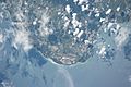
Photo shows Aguada, Aguadilla and Isabela taken from the ISS Expedition 53
-
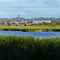
Remains of the Coloso sugarmill in Aguada

See also
 In Spanish: Aguada (Puerto Rico) para niños
