
1918 San Fermín earthquake facts for kids
| UTC time | 1918-10-11 14:14:42 |
|---|---|
| ISC event | 913306 |
| USGS-ANSS | ComCat |
| Local date | October 11, 1918 |
| Local time | 10:14:42 |
| Magnitude | 7.1 Mw |
| Depth | 15 km (9.3 mi) |
| Epicenter | 18°48′N 67°13′W / 18.8°N 67.22°W |
| Type | Unknown |
| Areas affected | Puerto Rico |
| Total damage | $4–29 million USD |
| Max. intensity | IX (Violent) |
| Tsunami | Yes |
| Casualties | 76–118 |
The 1918 San Fermín earthquake, also known as the Puerto Rico earthquake of 1918, was a powerful natural disaster that hit the island of Puerto Rico. It happened on October 11, 1918, at 10:14:42 in the morning local time.
The earthquake was very strong, measuring 7.1 on the moment magnitude scale. This scale helps scientists measure the total energy released by an earthquake. On another scale, the Mercalli intensity scale, it was rated IX (Violent). This scale describes how much shaking people felt and how much damage happened.
The main part of the earthquake, called the epicenter, was located off the northwest coast of Puerto Rico. This area is near a deep ocean trench called the Puerto Rico Trench. The earthquake also caused a huge ocean wave, known as a tsunami, which crashed onto the island's west coast.
Together, the earthquake and tsunami caused a lot of damage and sadly, many people lost their lives. Between 76 and 118 people died, and property damage was estimated to be between $4 million and $29 million. It was one of the worst natural disasters Puerto Rico has ever faced.
Contents
What Caused the Earthquake?
The 1918 San Fermín earthquake started in the Mona Passage. This is a strait, or narrow stretch of water, located between the island of Puerto Rico and the Dominican Republic. The strongest shaking from the earthquake was felt most intensely in this area.
The earthquake's energy caused the ground to shake very violently. This shaking was rated as intensity IX on the Mercalli intensity scale. The western towns of Puerto Rico, especially Mayagüez, were hit the hardest.
Damage Across the Island

Many buildings and structures on the west coast of Puerto Rico were badly damaged or completely destroyed. Factories and other production places were ruined. Bridges and roads also suffered severe damage, making it hard to travel.
The earthquake also caused several mudslides in areas where the shaking was very strong. However, these mudslides did not cause many deaths. River currents were also affected, which weakened the foundations of many bridges and led to their collapse.
Undersea telegraph cables, which were used for communication with other places, were damaged. This cut off Puerto Rico from outside communication for a while.

Sadly, between 76 and 116 people died because of the earthquake and tsunami. About 40 of these deaths were caused by the tsunami waves that swept over coastal communities. The total cost of the damage to buildings and property was estimated to be between $4 million and $29 million.
In Mayagüez, which was the largest city affected, about 700 buildings made of stone or brick were damaged. Also, 1,000 wooden houses were affected, leaving many people without homes. Important buildings like the church, post office, and town hall were severely damaged. Many people were so scared of the aftershocks (smaller earthquakes that happen after a big one) that they camped out in the hills for weeks.
The Tsunami's Impact
After the earthquake, a large tsunami hit the west coast of Puerto Rico. It probably arrived only 4 to 7 minutes after the main earthquake. The waves were very tall in some places. They were estimated to be about 6 meters (nearly 20 feet) high at Point Agujereada. At Point Borinquen, they were about 4.5 meters (15 feet) high, and at Point Jiguero, they reached about 5.2 meters (17 feet).
Several villages along the coast were destroyed by these powerful waves. It's believed that about 40 people drowned because of the tsunami, with 32 of those deaths happening in the town of Aguadilla alone.
Aftershocks: More Shaking
After the main earthquake, several smaller earthquakes, called aftershocks, were felt. These happened right away. Later, on October 24 and November 12, two more strong aftershocks were reported. Luckily, these later aftershocks did not cause any new damage.
Images for kids
-
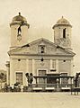
Cathedral of Mayagüez after the first earthquake; further damage toppled the left tower
-

Destroyed brick homes in Mayagüez
-
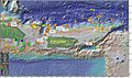
Map showing the epicenters of all the magnitude 5 and greater earthquakes around Puerto Rico for the last 100 years
-
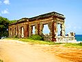
Aguadilla Punta Borinquen Lighthouse Ruins—an 1889 lighthouse destroyed by the tsunami


See also
 In Spanish: Terremoto de san Fermín de 1918 para niños
