Atalaya, Aguada, Puerto Rico facts for kids
Quick facts for kids
Atalaya
|
|
|---|---|
|
Barrio
|
|

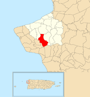
Location of Atalaya within the municipality of Aguada shown in red
|
|
| Commonwealth | |
| Municipality | |
| Area | |
| • Total | 2.36 sq mi (6.1 km2) |
| • Land | 2.36 sq mi (6.1 km2) |
| • Water | 0.00 sq mi (0 km2) |
| Elevation | 794 ft (242 m) |
| Population
(2010)
|
|
| • Total | 3,108 |
| • Density | 1,316.9/sq mi (508.5/km2) |
| Source: 2010 Census | |
| Time zone | UTC−4 (AST) |
Atalaya is a special area, known as a barrio, located in the town of Aguada, Puerto Rico. It's part of the beautiful island of Puerto Rico. In 2010, about 3,108 people called Atalaya home.
Contents
History of Atalaya
Puerto Rico became a territory of the United States after the Spanish–American War in 1898. This happened because of a peace agreement called the Treaty of Paris of 1898.
In 1899, the United States government counted everyone living in Puerto Rico. They found that Atalaya barrio and a nearby barrio called Jagüey had a combined population of 1,195 people.
The population of Atalaya has grown over the years:
| Historical population | |||
|---|---|---|---|
| Census | Pop. | %± | |
| 1950 | 1,449 | — | |
| 1960 | 1,541 | 6.3% | |
| 1980 | 2,350 | — | |
| 1990 | 2,430 | 3.4% | |
| 2000 | 2,767 | 13.9% | |
| 2010 | 3,108 | 12.3% | |
| U.S. Decennial Census 1899 (shown as 1900) 1910-1930 1930-1950 1960 1980-2000 2010 |
|||
What are Sectors?
Barrios like Atalaya are often divided into even smaller areas. These smaller areas are called sectores (which means sectors in English).
Think of it like this: a town has different neighborhoods, and those neighborhoods might have smaller blocks or communities within them. Sectors are similar to these smaller communities. They can have different names, like urbanización or reparto.
Sectors within Atalaya
The following sectors are found in Atalaya barrio:
- Sector Juanito Abreu
- Sector Los Concepción
- Sector Los Cordero
- Sector Los Rodríguez
- Sector Matias
- Sector Pedro Ruíz
- Tramo Carretera 411
Earthquakes in the Region
Puerto Rico experienced a series of earthquakes between 2019 and 2020. During this time, some people in Atalaya had to leave their homes because of damage.
A school in a nearby barrio, the Lydia Meléndez School in Asomante, became a safe place for them. Residents from Atalaya, Cerro Gordo, and Las Marías found shelter there.
See also
 In Spanish: Atalaya (Aguada) para niños
- List of communities in Puerto Rico
- List of barrios and sectors of Aguada, Puerto Rico
 | May Edward Chinn |
 | Rebecca Cole |
 | Alexa Canady |
 | Dorothy Lavinia Brown |


