
Aguada barrio-pueblo facts for kids
Quick facts for kids
Aguada barrio-pueblo
Pueblo de Aguada
|
|
|---|---|
|
Municipality Seat
|
|

Aguada City Hall
|
|

Location of Tejas within the municipality of Aguada shown in red
|
|

Aguada barrio-pueblo
Location in Caribbean
|
|
| Commonwealth | |
| Municipality | |
| Area | |
| • Total | 0.11 sq mi (0.3 km2) |
| • Land | 0.11 sq mi (0.3 km2) |
| • Water | 0.00 sq mi (0 km2) |
| Elevation | 59 ft (18 m) |
| Population
(2010)
|
|
| • Total | 1,324 |
| • Density | 12,036.4/sq mi (4,647.3/km2) |
| Source: 2010 Census | |
| Time zone | UTC−4 (AST) |
Aguada barrio-pueblo is a small area, or barrio, in Aguada, Puerto Rico. It's like the main downtown part of the municipality. In 2010, about 1,324 people lived here. Aguada barrio-pueblo has two smaller parts called California and Rosario.
Just like in Spain, many towns in Puerto Rico have a special area called a pueblo. This pueblo usually has a main square, the town's important buildings like the city hall, and a Catholic church. Every year, special festivals called Fiestas patronales (patron saint festivals) are held in this central square.
The Main Square and Its Church
The main square, also known as the central plaza, is a lively spot for both official events and just hanging out. People gather here to have fun and socialize from morning until night. Old Spanish laws from the early 1800s said that the plaza should be big enough for "parties" (celebrations and festivities). These laws also said that the streets nearby should have comfortable walkways to protect people from the sun and rain.
A church called the Ermita de Espinar was first built in 1516. After it was destroyed by indigenous people, it was rebuilt in 1639.
Right across from the main square in Aguada barrio-pueblo is the Parroquia San Francisco de Asís, which is a Roman Catholic church. It was built in 1692 and then rebuilt in 1793. Sadly, it was destroyed by the 1918 San Fermín earthquake. However, it was rebuilt again between 1924 and 1936, following designs by Antonio Martínez and José Lazaro. Beautiful stained glass windows were added in 1956 and again in 1964. The inside of the church was updated in 1993.
The oldest festival in Puerto Rico was celebrated in and around this church in Aguada. It honored the Immaculate Conception and was held for many years, starting in the 1500s. This festival lasted for eight days each year. However, the church eventually ended it because it had become too focused on business.
Today, Aguada's yearly patron saint festival, which honors Francis of Assisi, takes place from late September to early October in the Plaza Carlos Ruiz.
Sectors
Barrios, which are like small areas within a town, are often divided into even smaller local areas called sectores (which means sectors in English). These sectors can have different names, such as urbanización (urbanization), reparto (development), barriada (neighborhood), or residencial (residential area).
Here are some of the sectores you can find in Aguada barrio-pueblo:
- Calle Elomita
- Calle Paz
- Este De La Calle Manuel Ruíz González
- Hogar Love and Care
- Oeste De La Calle Manuel Ruíz González
- Residencias de Colores
- Ruíz González
- Sector California
- Sector Rosario
- Urbanización Moropó
- Urbanización San Cristóbal
Aguada barrio-pueblo is also part of the main urban area of Aguada.
Gallery
Places in Aguada barrio-pueblo:
-
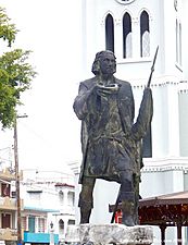
A statue of Cristóbal Colón in the plaza
-
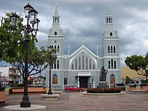
The main plaza and the Roman Catholic Church of Aguada
-
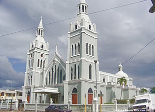
Parroquia de San Francisco de Asís


See also
 In Spanish: Aguada (Aguada) para niños
- List of communities in Puerto Rico
- List of barrios and sectors of Aguada, Puerto Rico
