
Naranjito, Puerto Rico facts for kids
Quick facts for kids
Naranjito
Municipio de Naranjito
|
|||
|---|---|---|---|
|
Town and Municipality
|
|||

Jesús Izcoa Moure Bridge in Naranjito
|
|||
|
|||
| Nicknames:
"La Ciudad de los Colores", "El Pueblo de los Changos"
|
|||
| Motto(s):
"Naranjito Brilla"
|
|||
| Anthem: Naranjito, mi hogar predilecto | |||

Map of Puerto Rico highlighting Naranjito Municipality
|
|||
| Sovereign state | |||
| Commonwealth | |||
| Founded | December 3, 1824 | ||
| Founded by | Braulio Morales | ||
| Barrios | |||
| Area | |||
| • Total | 28.4 sq mi (73.54 km2) | ||
| • Land | 28.2 sq mi (73.0 km2) | ||
| • Water | 0.2 sq mi (0.54 km2) | ||
| Elevation | 2,997 ft (700 m) | ||
| Population
(2020)
|
|||
| • Total | 29,241 | ||
| • Rank | 41st in Puerto Rico | ||
| • Density | 1,029.6/sq mi (397.62/km2) | ||
| Demonym(s) | Naranjiteños | ||
| Time zone | UTC−4 (AST) | ||
| ZIP Codes |
00719
|
||
| Area code(s) | 787/939 | ||
| Major routes | |||


Naranjito is a town and municipality in Puerto Rico. It is located in the central part of the island. Naranjito is south of Toa Alta and north of Barranquitas and Comerío. It is also east of Corozal and west of Bayamón.
The town is divided into seven main areas called barrios, plus the downtown area known as Naranjito Pueblo. Naranjito is part of the larger San Juan-Caguas-Guaynabo Metropolitan area.
Contents
History of Naranjito
The idea to create the municipality of Naranjito started in 1810. After some challenges, Don Braulio Morales successfully founded the town on December 3, 1824. He founded it in the area that shared the same name, on land given by Doña Manuela Rivera and Don Braulio Morales himself.
Morales was named "Captain Settler" and also became the first mayor. The name "Naranjito" means "little orange tree." It came from a small, sour orange tree that helped travelers find their way to the town of Toa Alta.
When it was founded, Naranjito had five main areas: Lomas, Guadiana, Achiote, Nuevo, and Cedro. In 1853, Cedro was split into Cedro Arriba and Cedro Abajo. The main part of the town today includes the San Miguel, San Antonio, and San Cristobal districts.
After the Spanish–American War, Puerto Rico became a territory of the United States in 1898. In 1899, a census showed that Naranjito had a population of 8,101 people.
On September 20, 2017, Hurricane Maria hit Puerto Rico. Naranjito was greatly affected. The town lost electricity and communication, and many roads were destroyed. The Guadiana River caused severe flooding in the town center. The storm also caused many landslides in Naranjito.
Geography of Naranjito
Naranjito is found in the central, mountainous part of Puerto Rico.
Rivers and Waterways
Several rivers and streams flow through Naranjito. These include the Río Cañas, Río Cibuco, Río Grande de Manatí, Río Guadiana, and Río Mavilla.
Barrios of Naranjito
Like all municipalities in Puerto Rico, Naranjito is divided into smaller areas called barrios. The main town buildings, central square, and a large Catholic church are located in the barrio known as "el pueblo."
Here are the barrios of Naranjito:
- Achiote
- Anones
- Nuevo
- Cedro Abajo
- Cedro Arriba
- Guadiana
- Lomas, also known as Lomas Garcia
- Naranjito barrio-pueblo
Population Data
| Historical population | |||
|---|---|---|---|
| Census | Pop. | %± | |
| 1900 | 8,101 | — | |
| 1910 | 8,876 | 9.6% | |
| 1920 | 10,503 | 18.3% | |
| 1930 | 11,645 | 10.9% | |
| 1940 | 13,954 | 19.8% | |
| 1950 | 15,927 | 14.1% | |
| 1960 | 17,319 | 8.7% | |
| 1970 | 19,913 | 15.0% | |
| 1980 | 23,633 | 18.7% | |
| 1990 | 27,914 | 18.1% | |
| 2000 | 29,709 | 6.4% | |
| 2010 | 30,402 | 2.3% | |
| 2020 | 29,241 | −3.8% | |
| U.S. Decennial Census 1899 (shown as 1900) 1910-1930 1930-1950 1960-2000 2010 2020 |
|||
The population of Naranjito has grown over the years. In 1899, there were 8,101 people. By 2020, the population had grown to 29,241.
Things to See and Do
Naranjito offers several interesting places to visit.
Landmarks and Places of Interest
- Anones Park
- Cancha Gelito Ortega
- Cedro Abajo Falls (also called Las Lagrimas Falls)
- La Marina Boardwalk
- La Plata Lake
- Las Avispas Hills
- Municipal Swimming Pool
- Trovador Plaza
- Mirador de Anones
- Puente Atirantado Jesús Izcoa Moure
- El Cerro Community
Economy of Naranjito
Historically, Naranjito's main farm products were coffee and tobacco. More recently, farmers have started growing fruits like bananas, oranges, and papayas. The town also has a popular poultry factory that focuses on dairy cattle, producing fresh milk. Many factories in Naranjito make clothing.
Culture and Events
Naranjito has a lively culture with many festivals and events throughout the year.
Festivals and Events
Naranjito celebrates its patron saint festival in September. This event is called the Fiestas Patronales de San Miguel Arcangel. It is a religious and cultural celebration. You can usually find parades, games, local crafts, rides, traditional food, and live entertainment.
Other fun festivals and events in Naranjito include:
- Mothers Day - May
- San Antonio Day - June
- Chango Festival - June
- Anon Festival - June
- Volleyball Tournament - February - June
- Archangel Saint Michael Day - September
- The Turkey Marathon - November
Sports in Naranjito
Naranjito is home to the Naranjito Changos. This is a professional male volleyball team. They are also known as Los Changos De Naranjito. The team is one of the most successful sports teams in Puerto Rico.
Transportation
Naranjito has 19 bridges that help people travel around the area.
Symbols of Naranjito
The municipality of Naranjito has its own official flag and coat of arms.
Flag of Naranjito
The flag of Naranjito is orange. It has two thin green stripes near the top and bottom edges. The orange color stands for the town's name, which means "little orange tree." The green color represents the green mountains around the town.
Coat of Arms of Naranjito
The coat of arms features a red cross, which is the symbol of the angel Saint Michael. He is the patron saint of Naranjito. A globe with a cross on it symbolizes God's power. The gold and red stripes come from the old symbol of the Guadiana family. The lily twigs honor Saint Anthony of Padua. The orange tree represents the small tree that gave the town its name. The crown at the top symbolizes the town's unity.
Education in Naranjito
Naranjito has several public and private schools. The Puerto Rico Department of Education manages the public schools.
Elementary Schools
- Bernarda Robles De Hevia
- Don Manolo Rivera
- Felipa Sanchez Cruzado
- Jose Archilla Cabrera
- Josefina Marrero
- Francisco Roque Muñoz
- Rosa Luz Zayas
- Silvestre Martinez
Middle and Junior High Schools
- Coleen Vazquez Urrutia
- Mercedes Rosado
- S.U. Adolfo Garcia
- S.U. Fidel G Padilla
- S.U. Pedro Fernandez
High Schools
- Francisco Morales
- Vocacional Rubén Rodríguez Figueroa
Private Schools
- Academia Santa Teresita (Kindergarten through 12th grade)
Naranjito in Media
A chase scene from the movie Fast & Furious 5 was filmed in Naranjito. In this scene, characters Dominic Toretto (Vin Diesel), Mia Toretto (Jordana Brewster), and Brian O'Connor (Paul Walker) are chased across rooftops. The filming took about a week. It was a challenging scene to shoot because the pathways were often slippery. The movie production hired 236 local technicians and 13,145 extras. This brought about $27 million to the local community.
Famous People from Naranjito
- Francisco López Cruz: An important music expert, musician, composer, and teacher. He worked to promote Puerto Rican Folk music.
- Yazaira Lopez: The winner of the TV show Va por Ti in 2014.
- Christian Nieves: A globally recognized cuatro player. The cuatro is a special Puerto Rican string instrument.
- Barbara Serrano: A well-known writer and the first runner-up for Miss World Puerto Rico in 2001.
Books About Naranjito
- El Chango. Apuntes Historicos del Pueblo de Naranjito-1824-1998, by Silvestre J. Morales (1999).
Images for kids
-
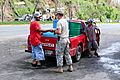
On October 11, 2017, the South Dakota National Guard distributed drinking water to residents of Naranjito after Hurricane Maria.
-
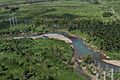
Electric power pole placement in Naranjito by the South Atlantic Division (SAD) USACE.
-
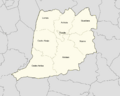
Map showing the subdivisions of Naranjito.
-
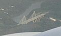
Puente Atirantado Jesús Izcoa Moure, a famous bridge in Naranjito.
.jpg)


See also
 In Spanish: Naranjito (Puerto Rico) para niños
