Naranjito barrio-pueblo facts for kids
Quick facts for kids
Naranjito barrio-pueblo
Pueblo de Naranjito
|
|
|---|---|
|
Municipality Seat
|
|

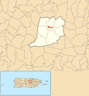
Location of Naranjito barrio-pueblo within the municipality of Naranjito shown in red
|
|
| Commonwealth | |
| Municipality | |
| Area | |
| • Total | 0.12 sq mi (0.3 km2) |
| • Land | 0.12 sq mi (0.3 km2) |
| • Water | 0 sq mi (0 km2) |
| Elevation | 374 ft (114 m) |
| Population
(2010)
|
|
| • Total | 1,157 |
| • Density | 9,641.7/sq mi (3,722.7/km2) |
| Source: 2010 Census | |
| Time zone | UTC−4 (AST) |
| ZIP code |
00719
|
Naranjito barrio-pueblo is a special area in Naranjito, a municipality in Puerto Rico. It's like the main town center or downtown area. This barrio is the administrative center, meaning it's where the local government offices are located.
In 2010, about 1,157 people lived here. Just like in Spain, many towns in Puerto Rico have a central area called a pueblo. This pueblo usually has a main square, government buildings, and a Catholic church. Every year, special festivals called Fiestas patronales (patron saint festivals) are held in the central square.
The population of Naranjito barrio-pueblo has changed over the years. In 1900, there were 614 people. The population grew steadily until the 1960s. By 2010, it was 1,157 residents.
Contents
The Central Plaza and Its Church
The central plaza, or town square, is a very important place. It's used for both official events and fun activities. People gather here from morning until night to socialize and relax.
Back in the early 1800s, Spanish laws called the Laws of the Indies guided how towns in Puerto Rico were built. These laws said the plaza should be big enough for celebrations and parties. They also stated that nearby streets should have comfortable walkways. These walkways would protect people from the sun and rain.
Right across from the central plaza in Naranjito barrio-pueblo, you'll find the Parroquia San Miguel Arcángel. This is a Roman Catholic church, an important part of the community.
History of Naranjito Pueblo
Naranjito barrio-pueblo was once part of Spain's official records. This changed after the Spanish–American War. In 1898, Puerto Rico was given to the United States by Spain. This happened under the rules of the Treaty of Paris of 1898. Puerto Rico then became an unincorporated territory of the United States.
Soon after, in 1899, the United States Department of War counted the people in Puerto Rico. They found that Naranjito Pueblo had a population of 614 residents at that time.
Understanding Local Sectors
Barrios in Puerto Rico are similar to small local areas or neighborhoods. These barrios are then divided into even smaller parts called sectores, which means sectors in English.
The types of sectors can be different. Some are simply called sector. Others might be known as urbanización, reparto, barriada, or residencial. Each name describes a different kind of neighborhood or housing area.
Here are some of the sectors you can find in Naranjito barrio-pueblo:
- Barriada La Marina
- Barriada Monte Verde
- Barriada San Antonio
- Barriada San Cristóbal
- Barriada San Miguel
- Calle Georgetti
- Calle Ignacio Morales Acosta
- Calle Pedro Cid
- Calle Víctor J. Mojica
- Sector Acueducto
See also
 In Spanish: Naranjito (Naranjito) para niños
 | John T. Biggers |
 | Thomas Blackshear |
 | Mark Bradford |
 | Beverly Buchanan |


