
Cedro Arriba facts for kids
Quick facts for kids
Cedro Arriba
|
|
|---|---|
|
Barrio
|
|

Looking north from Cedro Arriba
|
|

Location of Cedro Arriba within the municipality of Naranjito shown in red
|
|

Cedro Arriba
Location in Caribbean
|
|
| Commonwealth | |
| Municipality | |
| Area | |
| • Total | 5.29 sq mi (13.7 km2) |
| • Land | 5.29 sq mi (13.7 km2) |
| • Water | 0 sq mi (0 km2) |
| Elevation | 1,722 ft (525 m) |
| Population
(2010)
|
|
| • Total | 3,876 |
| • Density | 732.7/sq mi (282.9/km2) |
| Source: 2010 Census | |
| Time zone | UTC−4 (AST) |
| Zip code |
00719
|
Cedro Arriba is a barrio (which is like a neighborhood or district) in the town of Naranjito, Puerto Rico. In 2010, about 3,876 people lived there. It's located in the central part of Puerto Rico, known for its green hills.
A Look at Cedro Arriba's Past
Cedro Arriba has an interesting history. After the Spanish–American War in 1898, Spain gave Puerto Rico to the United States. This happened under a special agreement called the Treaty of Paris of 1898. Puerto Rico then became a territory of the United States.
In 1899, the U.S. government counted the people living in Puerto Rico. At that time, Cedro Arriba had a population of 915 residents. Over the years, the number of people living in Cedro Arriba has grown quite a bit. By 2010, the population had increased to 3,876.
Understanding Barrios and Sectors
In Puerto Rico, a barrio is a type of local area, similar to a district or a large neighborhood. These barrios are then divided into even smaller parts called sectores (which means "sectors" in English).
There are different kinds of sectors. Some are simply called sector, while others might be known as urbanización (a housing development) or barriada (a smaller neighborhood). Cedro Arriba has many different sectors within its boundaries.
Images for kids
-
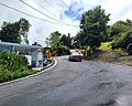
Puerto Rico Highway 809 in Cedro Arriba

See also
 In Spanish: Cedro Arriba para niños
- List of communities in Puerto Rico
- List of barrios and sectors of Naranjito, Puerto Rico
