
Barranquitas, Puerto Rico facts for kids
Quick facts for kids
Barranquitas
Municipio Autónomo de Barranquitas
|
|||
|---|---|---|---|
|
Town and Municipality
|
|||

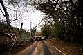
Agricultural landscape in Quebradillas
|
|||
|
|||
| Nicknames:
"La Cuna de Próceres", "Cuna Feria de Artesanías", "El Altar de la Patria", "El Pueblo de Luis Muñoz Rivera"
|
|||
| Anthem: "Aquí en el centro de nuestra tierra" | |||

Map of Puerto Rico highlighting Barranquitas Municipality
|
|||
| Sovereign state | |||
| Commonwealth | |||
| Settled | early 19th century | ||
| Founded | June 3, 1803 | ||
| Founded by | Antonio Aponte Ramos | ||
| Barrios | |||
| Area | |||
| • Total | 33.21 sq mi (86.01 km2) | ||
| • Land | 33 sq mi (86 km2) | ||
| • Water | 0.004 sq mi (.01 km2) | ||
| Population
(2020)
|
|||
| • Total | 28,938 | ||
| • Rank | 42nd in Puerto Rico | ||
| • Density | 871.40/sq mi (336.449/km2) | ||
| Demonym(s) | Barranquiteños | ||
| Time zone | UTC-4 (AST) | ||
| ZIP Code |
00794
|
||
| Area code(s) | 787/939 | ||
| Major routes | |||
| Website | http://barranquitaspr.net/pueblo/ | ||


Barranquitas is a small mountain town and municipality located in the central region of Puerto Rico. It's nestled among hills and mountains, about an hour's drive from San Juan, the capital city. The town is known for its beautiful natural features, including deep canyons.
Barranquitas is part of the San Juan-Caguas-Guaynabo Metropolitan Statistical Area. It is divided into 6 main areas called barrios, plus the downtown area known as Barranquitas Pueblo.
Contents
History of Barranquitas

Barranquitas was founded in 1803 by Antonio Aponte Ramos. Long before that, the area was home to the Taino people, led by a chief named Orocobix.
In the early 1900s, people from Barranquitas and the nearby city of Comerío had a brief, friendly rivalry over their territories. In 1899, a census showed that Barranquitas had a population of 8,103 people.
Hurricane Maria's Impact
On September 20, 2017, Hurricane Maria caused a lot of damage in Barranquitas. The strong winds and heavy rain led to many landslides. Roads were blocked by fallen trees, telephone poles, and damaged highways. This made it hard for help to reach residents for weeks.
Many homes were destroyed, and the town's agriculture was severely impacted. Farmers lost their crops, including plantain trees and other vegetables. For over a month after the hurricane, most residents did not have electricity.
Geography of Barranquitas
Barranquitas is a landlocked municipality, meaning it has no coastline. It is located in the middle of the Cordillera Central, which is the main mountain range in Puerto Rico. The area is mostly mountainous, with peaks like La Torrecilla and Farallón.
Barranquitas is also home to the impressive San Cristóbal Canyon and Las Bocas Canyon. These canyons are some of the deepest in the West Indies.
Rivers and Waterways
Several rivers flow through Barranquitas, including the Río de Barranquitas, Río Grande de Manatí, Piñonas, Río Hondo, and Río Usabón. There are also 14 bridges in the municipality.
Barrios of Barranquitas

Like all municipalities in Puerto Rico, Barranquitas is divided into smaller areas called barrios. The main town area, with its municipal buildings and central square, is called Barranquitas Pueblo.
- Barrancas
- Barranquitas barrio-pueblo
- Cañabón
- Helechal
- Honduras
- Palo Hincado
- Quebrada Grande
- Quebradillas
Special Communities
Some areas in Barranquitas are part of the "Special Communities of Puerto Rico" program. These are communities that need extra support and resources. In Barranquitas, these include parts of Cañabón barrio, Quebrada Grande barrio, and several neighborhoods like El Amparo, La Vega, La Loma, La Torre, Los Pinos, and Tres Caminos.
Energy Initiatives
In 2019, Barranquitas joined an Energy Consortium with other nearby municipalities like Villalba, Orocovis, Morovis, and Ciales. This group works together to create strong and efficient energy systems. Their goal is to protect their communities and ensure power supply, especially during natural disasters.
Tourism and Landmarks
Barranquitas is a popular place for tourists, especially Puerto Ricans. It is the burial place of two important Puerto Rican leaders: Luis Muñoz Rivera, who was born in Barranquitas, and his son, Governor Luis Muñoz Marín.
Places to Visit
- Luis Muñoz Rivera's Birthplace: This house has been turned into a museum.
- Muñoz Rivera Family Mausoleum: The resting place of Luis Muñoz Rivera, his son Luis Muñoz Marín, and other family members.
- San Cristóbal Canyon and Las Bocas Canyon: Natural wonders offering stunning views.
- El Cortijo Castle: An old, historic building that now serves as a museum.
- Camp Morton (Campamento Morton): A popular spot for outdoor activities and retreats.
To encourage tourism, the Puerto Rico Tourism Company launched the Voy Turistiendo (I'm Touring) campaign in 2021. The Barranquitas page in their passport book highlights the San Cristóbal Canyon, Plaza Bicentenaria, the Muñoz Rivera Family Museum, and the Artisans Fair.
Culture and Events

Barranquitas is known for its lively festivals and events.
Festivals and Events
- Patron Saint Festival: Celebrated in June, the Fiestas Patronales de San Antonio de Padua is a religious and cultural event. It features parades, games, local crafts, amusement rides, traditional food, and live entertainment.
- Apio Festival (Festival del Apio): Held in April or May, celebrating the local root vegetable.
- National Crafts Fair of Barranquitas: This fair has been celebrated for over 50 years and takes place in July. It showcases the work of local artisans.
- Viva Mi Calle Festival: Celebrated in November.
- Christmas Tree Lighting: An annual event in December to kick off the holiday season.
Sports in Barranquitas
Barranquitas does not have professional sports teams. However, it has popular amateur teams, especially in baseball and volleyball. The baseball team is called the "Proceres," a name that honors the many important historical figures born in the town.
Economy
Agriculture in Barranquitas
.jpg)
Agriculture is an important part of Barranquitas's economy. Farmers grow various crops, including plantain, coffee, lemons, ají dulce (a sweet pepper), and yams. The main crop is apio, a root vegetable similar to a potato.
Local Industry
Barranquitas also has industries that produce footwear and clothing.
Population and Demographics
| Historical population | |||
|---|---|---|---|
| Census | Pop. | %± | |
| 1900 | 8,103 | — | |
| 1910 | 10,503 | 29.6% | |
| 1920 | 11,600 | 10.4% | |
| 1930 | 14,901 | 28.5% | |
| 1940 | 17,096 | 14.7% | |
| 1950 | 17,605 | 3.0% | |
| 1960 | 18,978 | 7.8% | |
| 1970 | 20,118 | 6.0% | |
| 1980 | 21,639 | 7.6% | |
| 1990 | 25,605 | 18.3% | |
| 2000 | 28,909 | 12.9% | |
| 2010 | 30,318 | 4.9% | |
| 2020 | 28,983 | −4.4% | |
| U.S. Decennial Census 1899 (shown as 1900) 1910-1930 1930-1950 1960-2000 2010 2020 |
|||
In 2020, the population of Barranquitas was 28,983. Almost all residents (99.9%) identify as Hispanic or Latino. Many people born in Barranquitas are known for having light-colored eyes and strong European features. Some also have a "mestizo" look, which means they have a mix of Taíno and European ancestry. This is because many Taíno people moved to the mountainous regions to escape slavery during Spanish colonization. Many Spanish and other European immigrants also settled here as coffee farmers, leading to intermarriage.
Symbols of Barranquitas
The municipality of Barranquitas has an official flag and a coat of arms, each with special meanings.
The Flag
The flag of Barranquitas has three horizontal stripes. The top stripe is white, representing the silver color found in the town's shield. The middle stripe is green, symbolizing the lush vegetation of the area. The bottom stripe is yellow, representing the gold color of the ravines in the San Cristóbal Canyon.
The Coat of Arms
The coat of arms features silver, a canyon, two ravines, gold slopes, a tree, gold leaves, a bell, and a crown. The ravines remind us of the San Cristóbal Canyon, which is located between Barranquitas and the neighboring municipality of Aibonito. The yagrumo trees are common in the high mountains of Puerto Rico and symbolize the elevated location of Barranquitas.
Education in Barranquitas
The Interamerican University of Puerto Rico has a campus in Barranquitas, offering higher education opportunities.
All public schools in Puerto Rico are managed by the Puerto Rico Department of Education. Many schools in Barranquitas teach students about agriculture and how to grow crops, reflecting the town's strong farming traditions.
| School | Level | Barrio | Public | Location(s) | Coords |
|---|---|---|---|---|---|
| Escuela La Torre | K-6 | Cañabón | Yes | Carr 770 km 2 (mile marker 1.2) Hm 1 (yard marker 110) Sector La Torre |
18°12′25″N 66°20′18″W / 18.207048°N 66.338311°W |
| Escuela Cañabón Abajo | K-6 | Barrancas | Yes | Carr 172 | |
| Escuela Mana Abajo | K-6 | Barrancas | Yes | Carr 771 km 9 (mile marker 5.6) Hm 2 (yard marker 220) Sector Mana Abajo | 18°14′09″N 66°18′22″W / 18.235955°N 66.306095°W |
| Escuela El Portón | K-6 | Honduras | Yes | Carr 156 km 17 (mile marker 11) Hm 7 (yard marker 770) Sector El Portón |
18°11′29″N 66°18′23″W / 18.191368°N 66.306278°W |
| Escuela El Farallón | K-6 | Quebradillas | Yes | Carr 152 km 7 (mile marker 4.3) Hm 6 (yard marker 660) |
18°14′16″N 66°17′36″W / 18.237845°N 66.293371°W |
| Escuela Sinforoso Aponte | K-6 | Quebradillas | Yes | Carr 152 km 7 (mile marker 4.3) Hm 6 (yard marker 660) |
18°12′45″N 66°17′27″W / 18.212475°N 66.290946°W |
| Escuela Petroamérica Pagán | K-6 | Pueblo | Yes | Calle Muñoz Rivera #14 |
18°11′11″N 66°18′27″W / 18.186292°N 66.307554°W |
| Escuela La Vega (Stephen S. Huse) | K-6 | Pueblo | Yes | Carr 771 km 0 (mile marker 0) Hm 3 (yard marker 330) Bda La Vega |
18°11′24″N 66°18′54″W / 18.190083°N 66.315011°W |
| Escuela S.U. Palo Hincado (Federico Degetau) | K-9 | Palo Hincado | Yes | Carr 156 km 11 (mile marker 6.8) Hm 4 (yard marker 440) |
18°11′23″N 66°20′34″W / 18.189742°N 66.342675°W |
| Escuela S.U. La Loma (Antonio Vázquez Ramos) | K-9 | Quebrada Grande | Yes | Carr 156 km 20 (mile marker 12) Hm 1 (yard marker 110) |
18°11′04″N 66°16′40″W / 18.184485°N 66.277771°W |
| Escuela S.U. Helechal | K-9 | Helechal | Yes | Carr 162 km 7 (mile marker 4.3) Hm 4 (yard marker 440) |
18°10′09″N 66°18′53″W / 18.169233°N 66.314842°W |
| Escuela S.U. Lajitas (Ramon T Rivera) | K-9 | Barrancas | Yes | Carr 771 km 5 (mile marker 3.1) Hm 4 (yard marker 440) | 18°13′26″N 66°18′48″W / 18.223767°N 66.31327°W |
| Escuela Pedro Laboy | 7-9 | Quebradillas | Yes | Carr 152 km 6 (mile marker 3.7) Hm 5 (yard marker 550) |
18°13′49″N 66°17′06″W / 18.23034°N 66.284873°W |
| Escuela José Berríos Berdecia | 7-9 | Pueblo | Yes | Calle Melitón Pereles |
18°11′16″N 66°18′33″W / 18.187759°N 66.309088°W |
| Escuela Pablo Colón Berdecia (Superior Vocational) | 10-12 | Pueblo | Yes | Calle Barcelo Final |
18°11′11″N 66°18′05″W / 18.186302°N 66.301289°W |
| Escuela Luis Muñoz Marín (Superior Commerce) | 10-12 | Quebradillas | Yes | Calle A Sector Nuevo |
18°11′30″N 66°18′28″W / 18.191551°N 66.307908°W |
| San Francisco de Asís School | K-9 | Helechal | No | Carr 719 km 2 (mile marker 1.2) Hm 5 (yard marker 550) Sector Hoya Honda |
18°10′05″N 66°18′34″W / 18.168068°N 66.30937°W |
Images for kids
-
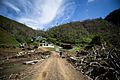
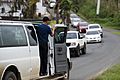
Returning home with water and food provided by FEMA on Oct. 17, 2017
-
Returning home with water
-
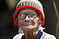
Elderly were especially vulnerable after Hurricane Maria left the island with no power
-
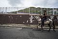
A resident on a horse after the hurricane
-
US Army transport vehicle carrying food and water provided by FEMA on Oct. 17, 2017
-
Volunteer distributing water after Hurricane Maria on Oct. 18, 2017
.jpg)
.jpg)
.jpg)
.jpg)
.jpg)
.jpg)
See also
 In Spanish: Barranquitas para niños
