
San Juan, Puerto Rico facts for kids
Quick facts for kids
San Juan
Municipio Autónomo de San Juan
|
|||
|---|---|---|---|
| Autonomous Municipality of San Juan | |||
|
Condado Beach
Choliseo Coliseum
|
|||
|
|||
| Nicknames:
La Llave de las Indias (The key to the Indies) La Ciudad Amurallada (The Walled City) Ciudad Capital (Capital City) |
|||

San Juan Municipality within Puerto Rico
|
|||
| Sovereign state | |||
| Commonwealth | |||
| Diocesan settlement | August 8, 1511 | ||
| Founded | August 15, 1521 | ||
| Founded by | Juan Ponce de León | ||
| Named for | John the Baptist | ||
| Barrios | |||
| Area | |||
| • Capital city and Municipality | 77.0 sq mi (199 km2) | ||
| • Land | 47.9 sq mi (124 km2) | ||
| • Water | 29.1 sq mi (75 km2) 37.8% | ||
| • Urban | 763.60 sq mi (1,977.7 km2) | ||
| Elevation | 26 ft (8 m) | ||
| Population
(2020)
|
|||
| • Capital city and Municipality | 342,259 | ||
| • Rank | 1st in Puerto Rico 57th in the United States |
||
| • Density | 7,147.1/sq mi (2,759.5/km2) | ||
| • Urban | 1,844,410 | ||
| • Urban density | 2,415.4/sq mi (932.6/km2) | ||
| • Metro | 2,350,126 | ||
| Demonym(s) | Sanjuanero -a | ||
| Time zone | UTC−4 (AST) | ||
| ZIP Codes |
00901, 00907, 00909, 00911-00913, 00915, 00917, 00918, 00920, 00921, 00923-00927
|
||
| Area codes | 787 and 939 | ||
| Major routes | |||
.jpg)


.jpg)


.jpg)


San Juan is the capital city and the most populated area in Puerto Rico. Puerto Rico is a territory of the United States. In 2020, San Juan was the 57th most populated city under the control of the United States, with over 342,000 people living there.
Spanish explorers founded San Juan in 1521. They first called it Ciudad de Puerto Rico, which means "Rich Port City". It is the second oldest European-founded capital city in the Americas, after Santo Domingo in the Dominican Republic. It is also the oldest European-founded city under United States rule.
Many old buildings are in the historic area called Old San Juan. These include the city's old walls, Fort San Felipe del Morro, and Fort San Cristóbal. Also, La Fortaleza is the oldest governor's mansion in the Americas that is still used today. These historic places became a UNESCO World Heritage Site in 1983.
Today, San Juan is Puerto Rico's most important seaport. It is also a major center for money, culture, and tourism. About 76% of Puerto Rico's population lives and works in the greater San Juan area. San Juan has also hosted many sports events, like the 1979 Pan American Games and parts of the World Baseball Classic.
Contents
Discovering San Juan's Past
Who Lived Here First?
Before Europeans arrived in 1493, the Taíno people lived in the area that is now San Juan. They were the first inhabitants of the island of Puerto Rico. Small remains of their fishing villages have been found, but many old sites were lost over time.
How San Juan Was Founded

In 1508, Juan Ponce de León started the first settlement called Caparra. It was named after an old Roman city in Spain. A year later, the settlement moved to a place called Puerto Rico, meaning "rich port." This new spot reminded them of a town in the Canary Islands.
On August 8, 1511, a local Catholic church group was started in the new settlement. In 1521, the town got its official name: Ciudad de Puerto Rico de San Juan Bautista. Many of the oldest European-founded places in the Western Hemisphere, like the Santo Tomás de Aquino Convent, were built in San Juan during this time.
Over time, people started calling the whole island "Puerto Rico." So, the city became known as "San Juan" to avoid confusion.
San Juan During Spanish Rule
San Juan was a key stop for Spanish ships traveling from Spain to the Americas. Because of its important location, many forts were built to protect the gold and silver being sent from the New World to Europe. This made San Juan a target for other powerful countries.
San Juan was attacked by the English in 1595 and 1598. The fort, El Morro, helped defend the city. In 1625, Dutch forces also attacked, burning parts of the city. But El Morro and the brave people of San Juan fought them off.
In 1797, the British attacked again during the French Revolutionary Wars. Their army tried to take the city, but Puerto Rico's defenses were too strong, and the British had to leave. Over time, San Juan grew as more people moved to the island.
San Juan and the Spanish-American War

In 1898, United States Navy ships arrived at San Juan Bay. On May 10, Captain Ángel Rivero Méndez ordered his men to fire on a U.S. ship, marking the first attack against Americans in Puerto Rico during the Spanish–American War.
Later, American troops landed in southwestern Puerto Rico. They faced some resistance from Spanish and Puerto Rican soldiers. All fighting stopped on August 13, 1898. Spain then gave the island to the United States by signing the Treaty of Paris.
San Juan in the 20th Century
.jpg)
In the early 1900s, San Juan continued to grow. Camp Las Casas in Santurce became a main training camp for Puerto Rican soldiers during World War I and World War II.
In 1947, Felisa Rincón de Gautier became the mayor of San Juan. She was the first woman to be elected mayor of a capital city in the Americas. She helped set up the island's first Civil Defense system.
In 1950, San Juan saw an uprising by the Puerto Rican Nationalist Party. They tried to attack government buildings, but the police stopped them.
San Juan in the 21st Century
San Juan has seen times of both slow growth and fast development. Some areas of the city have been rebuilt and improved. The city has also been the site of many protests, including those against the United States Navy in 2001 and against Governor Ricardo Rosselló in 2019.
In September 2017, Hurricane Maria hit Puerto Rico directly. It caused a lot of damage to San Juan's electricity, water, transportation, and communication systems. However, by 2019, the city had made great progress in rebuilding, and tourism was bouncing back.
Today, San Juan is still a very important cultural, financial, and industrial center for Puerto Rico and the Caribbean. It has many factories that make things like medicines, rum, and clothing. The Puerto Rico Convention Center, opened in 2005, is the largest of its kind in the Caribbean.
Exploring San Juan's Geography

San Juan is on the northeastern coast of Puerto Rico, near the Atlantic Ocean. It covers about 77 square miles, with about 38% of that being water. The main water bodies are San Juan Bay and two lagoons, Condado and San José. The highest point in San Juan is a hill in Caimito, about 1,030 feet above sea level.
San Juan is surrounded by other cities like Guaynabo, Trujillo Alto, and Carolina. These cities, along with Bayamón and Cataño, form the "Área Metro," which is the heart of the larger San Juan metropolitan area.
San Juan's Climate
_-_San_Juan_Area,_PR(ThreadEx).svg)
San Juan has a tropical monsoon climate, which means it's warm and rainy all year. The average temperature is about 81°F (27°C). It can get to 90°F (32°C) or higher about 79 days a year, mostly in the summer.
In winter, temperatures can drop to around 60°F (16°C). The coolest temperature ever recorded was 60°F (16°C) in March 1957. The hottest was 98°F (37°C) in October 1981.
San Juan gets about 56 inches (143 cm) of rain each year, spread out over about 198 days. Even with all the rain, the city gets a lot of sunshine, about 2,970 hours per year.
Sometimes, waves of Saharan dust blow over San Juan from Africa. These dust storms can make the air hazy and cause the city to feel hotter. Local groups and the EPA now have warning systems to help people prepare for these events.
Hurricane Maria's Impact
.jpg)
Hurricane Maria hit Puerto Rico on September 20, 2017. San Juan experienced strong winds and widespread flooding. Many roofs were blown off buildings. The neighborhood of La Perla was heavily damaged. Flooding from Lake La Plata caused flash floods in nearby towns. Sadly, at least eight people died from the flooding.
San Juan's Beautiful Beaches

San Juan has many beaches, all open to the public, facing the Atlantic Ocean. In the Islet of San Juan, you can find Los Cables Beach and La Perla Beach. Capitolio Beach is north of the Puerto Rico Capitol. El Escambrón Beach is very popular because reefs protect it from strong waves.
In Santurce, beaches include Ocean Park Beach and Condado Beach. Ocean Park and Condado beaches are the largest in the city. They have many hotels and businesses for tourists.
Protecting San Juan's Beaches
Like other beaches in the Caribbean, San Juan's beaches are facing coastal erosion. This means the sand is slowly being washed away. Ocean Park beach is especially at risk. Experts are working to understand and fix this problem.
Parks and Green Spaces in San Juan
San Juan has many parks, including public parks, historic parks, and nature reserves. These parks are managed by different groups, like the city government and the National Park Service.
San Juan's Ecological Corridor
The San Juan Ecological Corridor is a special project to protect nature in the city. It includes six different areas:
- The Cupey Arboretum, which protects areas along the Río Piedras.
- The Doña Inés Mendoza Urban Forest, a small forest in Sabana Llana Sur.
- The Los Capuchinos Forest, which covers a small karst area.
- The New Millennium State Forest, one of Puerto Rico's state forests.
- The San Juan Waterworks, an old aqueduct and historic area.
- The University of Puerto Rico Botanical Garden.
Historic Parks to Explore
The San Juan National Historic Site includes El Morro Esplanade. This is a large open area between El Morro and Ballajá in Old San Juan. It offers great views of the San Juan Bay. People love to have picnics and fly kites here.
Near the Capitol of Puerto Rico, you'll find Iglesias Pantín and Rafael Hernández Marín parks. There's also a line of monuments, including the Walkway of the Presidents. The Loma de los Vientos is a small green area near Castle San Cristóbal. It often hosts events like Epiphany celebrations.
Luis Muñoz Rivera Park is a large park in Puerta de Tierra. It's the biggest public square in Puerto Rico. It has historic sites like the San Gerónimo Powderhouse, which used to store gunpowder. The park also has gardens, restaurants, and beach access.
The Polvorín de Miraflores is a historic park near the Puerto Rico Convention Center. This old ammunition storage house dates back to the mid-1700s.
City Parks for Fun

Some fun parks in San Juan include Bahía Urbana, a waterfront park in Old San Juan. The Paseo de Puerta de Tierra is a walkway along the ocean cliffs. It connects the Capitol to El Escambrón Beach.
Ventana al Mar, Laguna del Condado Jaime Benítez Park, and Parque del Indio are in the Condado district. Parque Central is a large park and recreation complex in southern Santurce. The Enrique Martí Coll Linear Park connects Central Park to Hato Rey.
Luis Muñoz Marín Park is one of the largest parks in the city. It has gazebos for events, green areas for walking and biking, and an artificial lake with paddleboats. Its main attraction is a cableway that crosses the park. It offers great views and takes you to the Roberto Clemente Coliseum.
Protecting Nature in San Juan
San Juan has many important natural areas. The San Juan Bay National Estuary protects ecosystems like the Caño Martín Peña Nature Reserve. Other protected areas include El Condado Lagoon and the San José Lagoon.
Two of Puerto Rico's state forests are in San Juan: the New Millennium Urban Forest and the San Patricio Urban Forest. These forests help protect the city's natural beauty.
San Juan's Cityscape and Architecture

What San Juan Looks Like

San Juan's buildings show many different styles because of its long history and many cultural influences. The oldest part of the city, Old San Juan, mostly looks Spanish. It has narrow streets made of blue cobblestones and old two-story houses.
Some old buildings have been restored and are now government offices or museums. Examples include the Ballajá Barracks, now a museum, and La Fortaleza, the governor's home since the 1500s. Old San Juan also has public squares like the Plaza de Armas and cathedrals like the Cathedral of San Juan Bautista.
The city is also famous for its huge walls and forts built by the Spanish. The main gate, Puerta de San Juan, was built in 1635 and is still there today.

Other parts of the city, like Puerta de Tierra, Santurce, Hato Rey, and Río Piedras, show a mix of Spanish, American, and Puerto Rican building styles. You can see Gothic, Baroque, Art Deco, and Mid-Century Modern designs. Many of these buildings are listed on the National Register of Historic Places.
The University of Puerto Rico, Río Piedras Campus also has many interesting buildings. These show the history of Puerto Rican architecture over the last 120 years.
San Juan's Neighborhoods

San Juan is divided into areas called barrios. Old San Juan is on a small island called the Isleta de San Juan. This island is connected to the mainland by bridges. It also has the neighborhood of Puerta de Tierra and most of Puerto Rico's main government buildings.
In 1951, the town of Río Piedras joined San Juan. This made San Juan four times bigger. The city now has 18 barrios. Eight of these barrios are further divided into smaller areas called subbarrios.
The 18 barrios are:
- Caimito
- Cupey
- El Cinco
- Gobernador Piñero
- Hato Rey Central
- Hato Rey Norte
- Hato Rey Sur
- Monacillo
- Monacillo Urbano
- Oriente
- Pueblo
- Quebrada Arenas
- Sabana Llana Norte
- Sabana Llana Sur
- San Juan Antiguo
- Santurce
- Tortugo
- Universidad
Old San Juan: A Historic Gem

During Spanish colonial times, most people lived in what is now Old San Juan. This area is on the western part of the Isleta de San Juan. It is known for its narrow streets paved with blue cobblestones and beautiful colonial buildings. Many of these buildings date back to the 1500s and 1600s.
Parts of Old San Juan are surrounded by huge walls and forts. These include the 16th-century Fort San Felipe del Morro and the 17th-century Fort San Cristóbal. Both are part of the San Juan National Historic Site. La Fortaleza, built in the 1500s, is the governor's mansion.
Other interesting old buildings include the San Juan City Hall, the San José Church (1523), and the Casa Blanca, which was the home of the Ponce de León family. The Cathedral of San Juan Bautista holds the tomb of explorer Juan Ponce de León. Old San Juan is a major tourist spot in Puerto Rico. Its bay is a popular stop for large cruise ships.
Santurce: A Lively Hub


Santurce is the largest and most populated barrio in San Juan. It was originally a settlement for freed African slaves. Later, it grew quickly with the arrival of steam trams and electric trolleys. The Puerto Rico Museum of Art and other important cultural places are in Santurce.
This barrio has popular subbarrios like Condado, known for its tourist hotels. Beaches like Ocean Park are great for swimming and surfing. Miramar is a residential area with the Puerto Rico Convention Center. In 2005, Miramar became a historic district.
Río Piedras: A Mix of History and Modern Life
South of Santurce is Hato Rey, which used to be part of the town of Río Piedras. Hato Rey was once grazing land for the king's cattle. Today, it is the financial center of the island. A part of this area is called Milla de Oro (Golden Mile) because of its many banks and businesses.
In the southern part of the city is Río Piedras. It was a separate town founded in the mid-1850s, with sugar cane farms and homes of wealthy San Juan residents. The main campus of the University of Puerto Rico is located here. In 1951, San Juan and Río Piedras merged. Today, Río Piedras is the largest area of San Juan. It is home to the main market, the University of Puerto Rico, and the San Juan Botanical Garden.
San Juan's People and Culture
Who Lives in San Juan?
San Juan has a population of 342,259 people, making it the largest city in Puerto Rico. From 1899 to 1950, the population numbers for San Juan did not include Río Piedras. When Río Piedras joined San Juan in 1951, the city's population grew a lot.
Most people in San Juan are of Hispanic or Latino background. Puerto Ricans are the largest group. There are also people of Dominican and Cuban descent. In recent years, more Americans who are not of Hispanic background have moved to San Juan. Many Stateside Puerto Ricans have also returned to live in the city.
San Juan is home to the largest Jewish community in Puerto Rico. There are over 2,000 people who attend local synagogues in Santurce and Isla Verde.
Arts and Culture in San Juan

San Juan is where many famous artists and musicians were born. These include dancer Sylvia del Villard and composer José Enrique Pedreira. International stars like opera singer Justino Díaz and Grammy winners Ramón Ayala and Ricky Martin are also from San Juan. Other notable people include writers Giannina Braschi and Tomas Blanco, actors Raul Julia and Benicio del Toro, and comedian José Miguel Agrelot.
Performing Arts
The Luis A. Ferré Performing Arts Center hosts many important music and art events. It is home to the Puerto Rico Symphony Orchestra and the Casals Festival, a major classical music festival. The center also hosts theater shows, like the musical Hamilton in 2019. The Conservatory of Music of Puerto Rico also plays a big role in the island's classical music scene.
Museums to Visit

San Juan has many art museums. The Puerto Rico Museum of Art has the largest art collection in Puerto Rico, with over 1,100 permanent pieces. The Puerto Rico Museum of Contemporary Art in Santurce focuses on modern art from Latin America and the Caribbean.
Other museums, like the Pablo Casals Museum and the Museum of the Americas, show historic items and art. There are also fun museums for kids, like the Children's Museum and the San Juan Wildlife Museum. The Bacardi Distillery in nearby Cataño is also a popular spot for visitors.
San Juan's Economy and Tourism
How San Juan Makes Money
San Juan's economy grew a lot after World War II. The city's economy mainly relies on companies that make various products. These include chemicals, medicines, rum, fertilizers, and electronic devices.
.jpg)
Tourism is also a very important industry. This is because San Juan is close to Puerto Rico's main airport, the Luis Muñoz Marín International Airport. The Condado Beach area has many fancy hotels for tourists. Historic places like El Morro and Old San Juan are popular tourist spots.
The Hato Rey district has a business area called Milla de Oro (Golden Mile). Many local and international banks have their main offices here. Hato Rey is often called the "Wall Street of the Caribbean" because it's so important to the economy.
Fun Things to Do in San Juan

San Juan has become a major tourist destination. It has hotels, museums, historic buildings, restaurants, parks, beaches, and shopping centers.
Old San Juan is a big draw for tourists. People love its historic colonial buildings and narrow streets paved with blue cobblestones. The city's old defensive walls and forts, especially El Morro and Castillo San Cristóbal, are very popular. These forts, along with La Fortaleza, were named a UNESCO World Heritage Site in 1984. Tourists and locals enjoy the restaurants and art galleries in this area.
Outside of Old San Juan, the Puerto Rico Convention Center District is a lively area. It includes the Puerto Rico Convention Center, which hosts many events like the Puerto Rico Comic Con. This district also has hotels, nightclubs, shops, cinemas, and restaurants.

Other popular tourist spots in San Juan include the Condado and Ocean Park Beaches, El Escambrón, and La Placita de Santurce. You can also visit the Luis A. Ferré Performing Arts Center, the Luis Muñoz Marín and Luis Muñoz Rivera Parks, and big shopping malls like Plaza Las Américas. The Museum of Art of Puerto Rico and the University of Puerto Rico Botanical Garden are also great places to visit.
San Juan is also a good starting point to explore other parts of Puerto Rico. You can visit the Bacardi Cathedral of Rum in Cataño, or the "Pork Highway" in Cayey. The bioluminiscent bay in Fajardo and the beaches of Piñones are also nearby. The El Yunque National Forest is a beautiful rainforest to explore.
Tourism After Hurricane Maria
By April 2019, repairs after Hurricane Maria were happening quickly. Most hotels in San Juan were open again, and life for tourists was back to normal. By October 2019, almost all tourist attractions were open, and tourism was recovering well. This was very important for Puerto Rico's economy.
Getting Around San Juan
Airports for Travelers

The San Juan area has two airports:
- The Luis Muñoz Marín International Airport (SJU) is San Juan's main airport. It is about eight miles from Old San Juan in the nearby town of Carolina. This airport serves over 30 airlines and is the busiest in the Caribbean. It is often called The Gateway to the Caribbean.
- The Fernando Ribas Dominicci Airport (SIG) is closer to Old San Juan. It is mainly used for smaller planes, charter flights, and some local flights. It used to be the main international airport for San Juan.
Major Roads and Highways

San Juan has many major roads and highways to help people get around:
- Puerto Rico Highway 52 (PR-52), also known as Luis A. Ferré Highway, goes from Santurce to Ponce.
- Puerto Rico Highway 1 (PR-1), also known as Carretera Central, runs from Santurce to Ponce.
- Puerto Rico Highway 2 (PR-2), also known as Kennedy Expressway, goes from Santurce to Ponce.
- Puerto Rico Highway 3 (PR-3), also known as 65 de Infantería Avenue, runs from Hato Rey to Salinas.
- Puerto Rico Highway 22 (PR-22), also known as José de Diego Expressway, goes from Santurce to Hatillo.
There are 193 bridges in San Juan, helping traffic flow across the city.
Public Transportation Options

San Juan has a very high number of vehicles on its roads, which often causes traffic jams. The city has expressways and main avenues, but traffic is still a big challenge.
The Puerto Rico Metropolitan Bus Authority (AMA) provides daily bus service to San Juan and nearby towns. They have over 270 buses and serve about 112,000 riders on weekdays.
To reduce traffic, the city built a metro system called "Tren Urbano" (Urban Train). This 10.7-mile line connects 16 stations. It opened in 2004. While it has helped some, it hasn't completely solved the city's traffic problems. There are plans to build a light rail system connecting San Juan and Caguas in the future.

The city is also planning to redesign San Juan to make it more appealing and reduce reliance on cars. For example, cars might not be allowed in the oldest part of the city, Old San Juan.
San Juan's Busy Port

The Port of San Juan is one of the busiest seaports in the Western Hemisphere. It is also the largest home-based cruise port in the world, with many cruise ships. It is managed by the Puerto Rico Ports Authority.
The AcuaExpreso is a ferry service in the San Juan Bay. The Cataño Ferry connects downtown Cataño to Old San Juan. The AquaExpress connects Old San Juan to Hato Rey and the Tren Urbano.
Healthcare in San Juan

San Juan has a good healthcare system with hospitals and clinics. The city government often holds health fairs for older people and those with disabilities.
There are 20 hospitals in San Juan. Half of them are run by the government. The largest and most important hospital in Puerto Rico and the Caribbean is the Rio Piedras Medical Center. This hospital, opened in 1956, includes eight other hospitals, such as:
- San Juan Municipal Hospital (run by the city)
- Industrial Hospital (for government employees)
- San Juan Pediatric Hospital (for children, run by the city)
- Pediatric Hospital (main trauma hospital for children)
- Centro Médico (main hospital for trauma cases)
- Centro Cardiovascular del Caribe (for heart surgery)
- Psychiatric Hospital (main psychiatric hospital)
- Psychiatric Correctional Hospital (hospital and correctional facility)
The city of San Juan also runs 10 smaller Diagnostic and Treatment Centers in different communities.
There are also 10 private hospitals in San Juan, including:
- Hospital Metropolitano
- Hospital Auxilio Mutuo
- Hospital de Veteranos (for U.S. veterans)
- Ashford Presbyterian Hospital
- San Jorge Children's Hospital (a well-known children's hospital)
- Hospital del Maestro (Teachers Hospital)
Sports in San Juan

San Juan has very successful sports teams. The Santurce Crabbers basketball team won many championships in the late 1990s and early 2000s. The San Juan Senators and the Santurce Crabbers baseball teams have won the Puerto Rican Professional Baseball League championship a total of 17 times. The Santurce Crabbers are also one of the top teams in the Caribbean Series.
San Juan has hosted many major sports events, such as:
- The 1966 Central American and Caribbean Games.
- The 1979 Pan American Games.
- The Caribbean World Series nine times.
- Parts of the 2006, 2009, and 2013 World Baseball Classic at Hiram Bithorn Stadium.
- The 1974 FIBA World Championship (basketball).
- The FIBA Americas Championship five times.
- The Latin American Regional Special Olympics in 2010.
- Major League Baseball's 2010 "San Juan Series" at Hiram Bithorn Stadium.
The San Juan Natatorium is a $28 million swimming center. It attracts swim meets and training from top U.S. colleges. In 2007, the San Juan Golf Academy opened, which will eventually include the city's first 9-hole golf course.
Professional Sports Teams
| Club | Sport | League | Venue |
|---|---|---|---|
| Cangrejeros de Santurce | Basketball | Baloncesto Superior Nacional | Roberto Clemente Coliseum |
| Cangrejeros de Santurce | Baseball | Puerto Rico Baseball League | Hiram Bithorn Stadium |
| Atléticos de San Juan | Football/Balompié (Soccer) | Puerto Rico Soccer League | |
| Academia Quintana | |||
| San Juan United | Puerto Rico Soccer League Second Division | Sixto Escobar Stadium |
Learning in San Juan
Colleges and Universities

San Juan is home to many of Puerto Rico's top colleges and universities. The University of Puerto Rico Río Piedras Campus is located here, along with its Medical Sciences Campus.
Other colleges in San Juan include the University of the Sacred Heart, the Polytechnic University of Puerto Rico, and the Metropolitan Campus of the Inter American University of Puerto Rico. There are also schools for fine arts and music, like the Puerto Rico Conservatory of Music.
Schools for All Ages
As of 2022-23, San Juan has 83 public schools serving over 24,000 students. These schools are run by the Puerto Rico Department of Education. Many specialized schools are in San Juan, focusing on subjects like Science, Math, Arts, Music, and Sports.
The city of San Juan also runs two bilingual schools, including a sports-focused school. These are the first city-run schools in Puerto Rico. Many private schools are also located in San Juan, such as Robinson and St. John's schools in Condado, and Academia San Jorge in Santurce.
International Connections
Diplomatic Offices
San Juan hosts many diplomatic offices from other countries. These include:
- Consulate-General from Colombia, Dominican Republic, Mexico, Spain, and Venezuela.
- Honorary Consulates from many countries like Argentina, Canada, Chile, France, Germany, Italy, Japan, and the United Kingdom.
Sister Cities Around the World
San Juan is connected to other cities around the world through "sister city" programs. These connections help promote cultural and economic ties.
- Domestic Sister Cities in the United States include Jacksonville, Florida, Honolulu, Hawaii, and Killeen, Texas.
- International Sister Cities include Cartagena, Colombia, Santiago, Dominican Republic, Guatemala City, Guatemala, San Juan, Philippines, Dubai, United Arab Emirates, Cádiz, Spain, and Madrid, Spain.
Images for kids
-
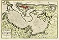
San Juan and bay, Puerto Rico, 1766
-
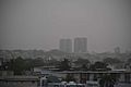
June 2022 haze event caused by Saharan dust.


See also
 In Spanish: San Juan (Puerto Rico) para niños
