Quebrada Arenas, San Juan, Puerto Rico facts for kids
Quebrada Arenas is a special place in San Juan, Puerto Rico. Its name means "sandy creek" in Spanish. It's one of the 18 areas called barrios in San Juan. What makes Quebrada Arenas unique is that it's the only rural barrio in San Juan. This means it's outside the main city area.
In 2010, about 2,747 people lived in Quebrada Arenas. It covers an area of about 2.46 square miles (6.37 square kilometers). This makes it the least crowded barrio in San Juan.
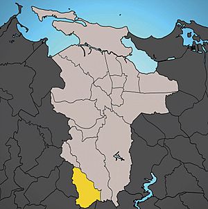
Quebrada Arenas is located in the southwest part of San Juan. It shares its borders with other towns like Aguas Buenas and Caguas to the south. To the west, it borders Guaynabo. Inside San Juan, it's next to the Caimito barrio on the east and the Tortugo barrio on the north.
Quick facts for kids
Quebrada Arenas
|
|
|---|---|

Puerto Rico Highway 1 in Quebrada Arenas
|
|

Location of Quebrada Arenas shown in yellow.
|
|
| Commonwealth | |
| Municipality | |
| Area | |
| • Total | 2.46 sq mi (6.4 km2) |
| • Land | 2.46 sq mi (6.4 km2) |
| • Water | 0 sq mi (0 km2) |
| Elevation | 446 ft (136 m) |
| Population
(2010)
|
|
| • Total | 2,747 |
| • Density | 1,116.7/sq mi (431.2/km2) |
| 2010 census | |
| Time zone | UTC−4 (AST) |
People and Numbers
This section looks at how the number of people living in Quebrada Arenas has changed over time. This is called demographics.
| Historical population | |||
|---|---|---|---|
| Census | Pop. | %± | |
| 1900 | 716 | — | |
| 1930 | 1,009 | — | |
| 1940 | 1,316 | 30.4% | |
| 1950 | 1,261 | −4.2% | |
| 1960 | 1,242 | −1.5% | |
| 1970 | 1,832 | 47.5% | |
| 1980 | 1,590 | −13.2% | |
| 1990 | 2,762 | 73.7% | |
| 2000 | 2,753 | −0.3% | |
| 2010 | 2,747 | −0.2% | |
| U.S. Decennial Census 1899 (shown as 1900) 1910-1930 1930-1950 1980-2000 2010 |
|||
See also
 In Spanish: Quebrada Arenas (San Juan) para niños
 | Selma Burke |
 | Pauline Powell Burns |
 | Frederick J. Brown |
 | Robert Blackburn |

