
Pueblo, San Juan, Puerto Rico facts for kids
Quick facts for kids
Pueblo
|
|
|---|---|

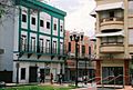
Plaza La Convalecencia in the main town square.
|
|

Location of Pueblo shown in yellow
|
|
| Commonwealth | |
| Municipality | |
| Area | |
| • Total | 0.73 sq mi (1.9 km2) |
| • Land | 0.73 sq mi (1.9 km2) |
| • Water | 0 sq mi (0 km2) |
| Elevation | 207 ft (63 m) |
| Population
(2010)
|
|
| • Total | 8,720 |
| • Density | 11,945.2/sq mi (4,612.1/km2) |
| 2010 census | |
| Time zone | UTC−4 (AST) |
Río Piedras Pueblo, also known simply as Pueblo, is a lively neighborhood in San Juan, Puerto Rico. It's one of 18 barrios (neighborhoods) in the city. This area used to be the main downtown part of a separate town called Río Piedras. But in 1951, Río Piedras joined with San Juan.
Pueblo is surrounded by other neighborhoods. To the west, you'll find Hato Rey Sur and El Cinco. To the north is Universidad barrio. And to the south and east, it borders Sabana Llana Sur. Pueblo is divided into six smaller sections called subbarrios. The famous University of Puerto Rico, Río Piedras campus is also located nearby.
Contents
History of Pueblo's Main Square
The Plaza de la Convalecencia
Before Pueblo had its main town square, there was a small chapel here. It was called the Hermitage of Our Lady of the Pillar and existed since at least 1647. The central plaza, which is the main town square, was created in 1823. This was when Río Piedras officially became its own municipality, or town. The old city hall building and the Casa del Rey (King's House) were built around this time.
The Church of Our Lady of the Pillar
Right across from the main plaza is the Church of Our Lady of the Pillar. This is a Roman Catholic church. It used to be the most important Catholic church for the entire former municipality of Río Piedras.
Population and Demographics
| Historical population | |||
|---|---|---|---|
| Census | Pop. | %± | |
| 1900 | 2,249 | — | |
| 1950 | 22,532 | — | |
| 1960 | 19,591 | −13.1% | |
| 1970 | 11,296 | −42.3% | |
| 1980 | 8,821 | −21.9% | |
| 1990 | 8,804 | −0.2% | |
| 2000 | 9,391 | 6.7% | |
| 2010 | 8,720 | −7.1% | |
| U.S. Decennial Census 1899 (shown as 1900) 1910-1930 1930-1950 1980-2000 2010 |
|||
Demographics is the study of a population. It looks at things like how many people live in an area. In 2010, Pueblo had a population of 8,720 people. They lived in an area of about 0.73 square miles (1.86 square kilometers).
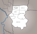
Subbarrios of Pueblo
Pueblo is divided into six smaller sections called subbarrios. These are like mini-neighborhoods within Pueblo.
- Buen Consejo
- Capetillo
- Monte Rey
- Río Piedras Antiguo
- Ubarri
- Venezuela
Gallery
-
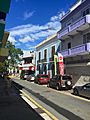
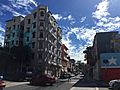
Cityscape of downtown Rio Piedras (Pueblo).
-
Subbarrios of Río Piedras Pueblo.
-
Old city hall of Río Piedras on Juan Ponce de Leon Ave.
-
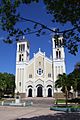
Church of Our Lady of the Pillar today.
-
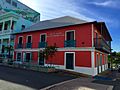
Historic Casa Georgetti, today site of a museum and cultural center.
-
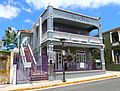
Historic building listed in the National Register of Historic Places since 2016, today referred to as the Puerto Rico Gay Pride Community Building.
-
Juan Ponce de León Avenue.


.jpg)


See also
 In Spanish: Río Piedras Pueblo para niños
