
Cayey, Puerto Rico facts for kids
Quick facts for kids
Cayey
Municipio Autónomo de Cayey
Cayey de Muesas
|
|||
|---|---|---|---|
|
Town and Municipality
|
|||

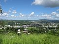
Cayey mountains, valley and hills with homes
|
|||
|
|||
| Nicknames:
"Ciudad de las Brumas", "Ciudad del Torito", "Ciudad del Coquí Dorado"
|
|||
| Anthem: "Alma Boricua" | |||

Map of Puerto Rico highlighting Cayey Municipality
|
|||
| Sovereign state | United States | ||
| Commonwealth | Puerto Rico | ||
| Founded | August 17, 1773 | ||
| Founded by | Juan Mata Vázquez | ||
| Barrios | |||
| Area | |||
| • Total | 50.20 sq mi (130.01 km2) | ||
| • Land | 50 sq mi (130 km2) | ||
| • Water | 0.004 sq mi (.01 km2) | ||
| Population
(2020)
|
|||
| • Total | 41,652 | ||
| • Rank | 20th in Puerto Rico | ||
| • Density | 829.77/sq mi (320.375/km2) | ||
| Demonym(s) | Cayeyanos | ||
| Time zone | UTC−4 (AST) | ||
| ZIP Codes |
00736, 00737
|
||
| Area code(s) | 787/939 | ||
| Major routes | |||


Cayey (Spanish pronunciation: [kaˈʝej]), also known as Cayey de Muesas, is a beautiful mountain town in central Puerto Rico. It's located in the Sierra de Cayey mountains, which are part of the larger Central Mountain range. Cayey is surrounded by mountains and is known for its cool weather and misty mornings.
The town is growing! Since the 1990s, Cayey has seen a lot of new businesses and stores open. Big companies like Wal-Mart and Coca-Cola have facilities here. Cayey also has a new sports arena and hospitals. It's home to one of the campuses of the University of Puerto Rico, called the University of Puerto Rico at Cayey.
Contents
History of Cayey
Founding and Early Days
.jpg)
Cayey was founded on August 17, 1773. The person who started the town was Juan Mata Vázquez, who became its first mayor. People often say that the name "Cayey" comes from a word in the Taíno language that means "a place of waters." The town was named Cayey de Muesas to honor Miguel de Muesas, who was the governor of Puerto Rico at that time.
Cayey is located in a valley between two mountain ranges: the Cordillera Central and the Sierra de Cayey. It's right in the middle of two important roads, PR-1 and PR-52. These roads offer amazing views of the island from high up in the mountains.
After the Spanish–American War, Puerto Rico became a territory of the United States in 1898. A census in 1899 showed that Cayey had a population of 14,442 people.
Education and Growth
In the 1950s, education started to grow in Cayey. The Interamerican University opened a branch that helped train teachers. Later, in 1967, the University of Puerto Rico opened its campus in Cayey. This campus was built on the land of a former military base called Henry Barracks. In the 1980s, El Turabo University also opened a campus in an old tobacco factory.
Cayey's healthcare also improved in the 1960s with the opening of the Mennonite Medical Center and a Municipal Hospital.
With the building of the highway PR-52, Cayey became a "bedroom community." This means many people live in Cayey and travel to nearby cities like San Juan (about 30 minutes away) or Ponce (about 45 minutes away) for work. Because of its nice weather and good schools, Cayey is a popular place to live for many families.
Hurricane Maria's Impact
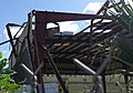
On September 20, 2017, Hurricane Maria hit Puerto Rico. It caused many landslides in Cayey due to heavy rain and strong winds. The hurricane sadly destroyed about 3,000 homes in the town.
Henry Barracks Military Base
The Henry Barracks Military Reservation was very important to Cayey from 1901 to 1966. It was a large area of land that provided jobs and resources for the people of Cayey. Many families moved to nearby neighborhoods because of the base.
In 1928, a powerful hurricane called San Felipe destroyed many buildings at Henry Barracks. After this, the Navy moved its station, and the U.S. Army took over more land. New concrete buildings were constructed for the soldiers.
Even after the military base closed in 1966, the land was used for other important projects. The National Guard had an officer training school there, and groups like the YMCA and Cuerpos de Paz used the facilities. The Encampment for Citizenship also held a program there, bringing young leaders from all over the world to learn about community development.
Geography and Climate
Cayey's Mountainous Landscape
Cayey is located in a valley surrounded by mountains. These include the Sierra de Cayey and the main parts of the Cordillera Central. The Carite Forest Reserve is also found here. Because of its location, Cayey is famous for its beautiful mountains, cool weather, and misty mornings, especially in winter.
During the time when Spain ruled Puerto Rico, soldiers were sent to Cayey. The cool weather there was similar to Spain, which helped the soldiers get used to the tropical climate. In winter, temperatures can sometimes drop into the 50s°F (10-15°C).
Rivers in Cayey
Several rivers flow through Cayey, including:
- Río Grande de Loíza
- Río Guavate
- Río Jájome
- Río de la Plata
- Río Maton
Weather in Cayey
Cayey has a humid, rainy, and mild climate. The town is nearly 1,500 feet (457 meters) high, so it has a subtropical highland climate.
- In summer, average high temperatures are around 82°F to 88°F (28°C to 31°C).
- In winter, average high temperatures are around 70°F to 78°F (21°C to 26°C).
- Low temperatures are around 68°F to 72°F (20°C to 22°C) in summer and 57°F to 63°F (14°C to 17°C) in winter.
The highest temperature ever recorded was 94°F (34°C), and the lowest was 45°F (7°C). Cayey gets a lot of rain, with an average of 100 inches (2,540 mm) per year.
Unique Wildlife: The Golden Coquí

The golden coquí (Eleutherodactylus jasperi) is a very rare frog species that lives only in Puerto Rico. It is possibly extinct now. These tiny frogs were found only in Cayey, in areas with lots of bromeliad plants in the Sierra de Cayey mountains. They get their name from the special song the male coquís sing at night.
The golden coquí is the smallest coquí frog in Puerto Rico, about the size of a dime when fully grown. Males are bright yellow, while females are lighter yellow and brown. What makes them truly special is that they are the only frog species in the New World known to give birth to live young! Coquí frogs are a beloved symbol of Puerto Rico.
Barrios of Cayey

Like all towns in Puerto Rico, Cayey is divided into smaller areas called barrios. The main town area, where the municipal buildings, central square, and large Catholic church are, is called "el pueblo".
Cayey has 22 barrios:
Sectors and Communities
Barrios are further divided into even smaller areas called sectores (sectors). These can be different types, like urbanización (housing development) or barriada (neighborhood).
Some communities in Cayey are part of the Comunidades Especiales de Puerto Rico (Special Communities of Puerto Rico). These are areas where people might face challenges and need extra support.
Buildings and Structures
Tall Towers
- Telemundo WKAQ TV Tower: This tower is 1,105 feet (336.8 meters) tall and is used for TV and FM radio broadcasting. It was built in 1971 and is the second tallest man-made structure in Puerto Rico.
- Cayey Pegasus Broadcasting WAPA-TV Tower: This tower is 1,091 feet (332.5 meters) tall and is the third tallest structure in Puerto Rico. It was built in 1966.
Pedro Montañez Stadium

The Pedro Montañez Municipal Stadium is the home field for the Toritos de Cayey, a Double-A baseball team. It's also used for sports events by the Benigno Fernandez Garcia Jr. High School.
Economy and Industry

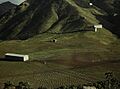
In the past, Cayey's economy was mostly based on farming crops like tobacco, sugarcane, and fruits. However, this has changed a lot. Today, most of the food products in Cayey are brought in from other islands or the mainland United States.
In the early 1900s, many farmers lost their land to large American companies that grew sugarcane and tobacco for export. In the 1950s and 1960s, some factories opened in Cayey. This was part of a program called "Operation Bootstrap" that encouraged industries to come to Puerto Rico with tax benefits.
By 1947, Cayey had a few factories, including a flower company, a baseball factory, and a uniform factory. These factories mostly hired women. When farming jobs decreased, many men moved to the United States or joined the military. In the 1950s, more factories opened, like the Gordonshire Knitting Mill and the Consolidated Cigar Corporation, which employed thousands of people from Cayey and nearby towns.
Today, Coca-Cola has a bottling plant in Cayey.
Tourism and Attractions
To encourage people to visit local places, the Puerto Rico Tourism Company created a campaign called Voy Turistiendo ("I'm Touring"). Cayey has many interesting places to visit:
- The "gastronomic route" in the Guavate barrio, famous for its food.
- Casa del Cuento y la Historia Cayeyana Ramón "Moncho" Gomez (Cayeyan Story and History House).
- Bosque de Pinos (Pine Forest).
- Siempre Verde for agrotourism (farm tourism).
Landmarks and Places of Interest
There are several important historical places in Cayey that are listed on the US National Register of Historic Places:
- Casa de Juana Rodríguez Morales (House of Juana Rodríguez Morales)
- Church Nuestra Señora de la Asunción of Cayey
- La Liendre Bridge
- Arenas Bridge
- Carretera Central (Central Road)
- Río Matón Bridge
- Carretera No. 4 (now PR-15), including the Principe Alfonso XII Bridge.
Other interesting places to visit include:
- La Robleda Protected Natural Area
- Comsat Station
- Ramón Frade Exhibit
- Brisas De Cayey
- Monumento a Los Tres Reyes Magos (Monument to The Three Kings)
- Carite Forest
- Lago Carite
- Escuela de Bellas Artes (School of Fine Arts)
- El Salón de La Fama del Deporte (Sports Hall of Fame)
- El Faro del Saber (Lighthouse of Knowledge)
- University of Puerto Rico at Cayey
- Museo de Arte Pio López (Pio López Art Museum)
- Pedro Montañez Municipal Stadium
- Teatro Municipal (Municipal Theater)
- Banda Municipal de Cayey (Municipal Band of Cayey)
- Tuna de Cayey (a traditional music group)
- Casino Real

Culture and Events
Festivals and Celebrations
Cayey celebrates its patron saint festival in August. This event, called the Fiestas Patronales Nuestra Señora de Asunción, is a religious and cultural celebration. It usually includes parades, games, local crafts, amusement rides, traditional food, and live music performances by famous artists.
Other festivals and events in Cayey are:
- Regional Fair – April
- Torito Olympics – April
Population Facts
| Historical population | |||
|---|---|---|---|
| Census | Pop. | %± | |
| 1900 | 14,442 | — | |
| 1910 | 17,711 | 22.6% | |
| 1920 | 23,618 | 33.4% | |
| 1930 | 28,797 | 21.9% | |
| 1940 | 31,391 | 9.0% | |
| 1950 | 36,656 | 16.8% | |
| 1960 | 38,061 | 3.8% | |
| 1970 | 38,432 | 1.0% | |
| 1980 | 41,099 | 6.9% | |
| 1990 | 46,553 | 13.3% | |
| 2000 | 47,370 | 1.8% | |
| 2010 | 48,119 | 1.6% | |
| 2020 | 41,652 | −13.4% | |
| U.S. Decennial Census 1899 (shown as 1900) 1910–1930 1930–1950 1960–2000 2010 2020 |
|||
| Race – Cayey, Puerto Rico – 2000 Census | ||
|---|---|---|
| Race | Population | % of Total |
| White | 41,771 | 88.2% |
| Black/African American | 1,834 | 3.9% |
| American Indian and Alaska Native | 89 | 0.2% |
| Asian | 64 | 0.1% |
| Native Hawaiian/Pacific Islander | 24 | 0.1% |
| Some other race | 2,602 | 5.5% |
| Two or more races | 986 | 2.1% |
Symbols of Cayey
The town of Cayey has its own official flag and coat of arms.
Flag of Cayey
The flag's design and colors come from the coat of arms, which is placed in the center of the flag inside a black ring. The flag also has four triangles pointing towards the center, two are white and two are red.
Coat of Arms of Cayey
The coat of arms features a three-peaked mountain, a red bull, and a wavy blue stripe. The blue stripe represents the many rivers and water sources in the area. It also honors the town's original patron saint. At the top of the shield is a silver lamb, which is a symbol of San Juan of Puerto Rico, along with a red book.
Transportation

Cayey is easy to reach by road. It has direct access to Puerto Rico Highway 52. The main business area is served by Puerto Rico Highway 14, which connects to Aibonito and the University of Puerto Rico campus. Puerto Rico Highway 15 goes to southern Cayey and Guayama.
Cayey is only about 25 miles (40 km) from San Juan and 38 miles (61 km) from Ponce. Because it's close to Caguas and has good road access, Cayey has grown a lot recently. There are 82 bridges in Cayey, many of which cross the Rio de la Plata.
Education in Cayey
_-_photograph_-_page_157.jpg)
Cayey has many schools for students of all ages.
Schools in Cayey
- Benigno Carrion (Grades K–5)
- Benigno Fernandez Garcia Middle School (Grades 6–8)
- Benjamin Harrison High School (Grades 9–12)
- Centro Adiest. Vocacional Gabriel Bibiloni
- Dr. Ramon Emeterio Betances (Grades 6–8)
- Emerita Leon Elemental (Grades PK–6)
- Especializada de Bellas Artes (Grades 7–12)
- Miguel Melendez Muñoz (Grades 9–12)
- Salvador Brau Elemental (Grades K–5)
- Su Certenejas II (Grades K–8)
- Su Eugenio Maria de Hostos (Grades K–8)
- Su Gerardo Selles Sola (Grades K–8)
- Virginia Vazquez Mendoza (Grades K–5)
Colleges and Universities
- University of Puerto Rico at Cayey
- University of Turabo at Cayey
- Instituto de Banca y Comercio (a smaller campus in Cayey)
- Liberty Technical College
Famous People from Cayey
Many notable people have come from Cayey, including:
- Alexis y Fido (music group)
- Ricardo Aponte (Brigadier General)
- Raymond Arrieta (comedian)
- Hiram Burgos (retired professional baseball pitcher)
- Christian Colón (professional baseball player, known for a key hit in the 2015 World Series)
- Ramón Frade (visual artist/painter)
- Luis Guzmán (actor)
- Jorge López (professional baseball pitcher)
- Alberto Mercado (boxer)
- Pedro Montañez (professional boxer)
- Joseph O. Prewitt Díaz (psychologist)
- Amazing Red (professional wrestler)
- Zuleyka Rivera (Miss Puerto Rico Universe 2006, Miss Universe 2006)
- Marcelino Sánchez (actor)
- Wisin & Yandel (reggaeton music group)
- José Ortiz (Puerto Rican basketball legend, former NBA player)
- Lionel Fernández Méndez (lawyer, politician, and founding member of the UPR Cayey campus)
Sister Cities
Cayey has special connections with two other cities:
- Middletown, Connecticut, USA
- Melilli, Sicily, Italy
Images for kids
-
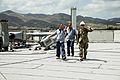
National Guard in Cayey after Hurricane Maria
-
Mennonite hospital in Cayey
-
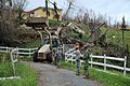
Damaged basketball court
-
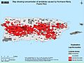
Map of landslides in Puerto Rico
-
Eastern side of Cayey
-
Cultivating tobacco in Cayey in 1941
-
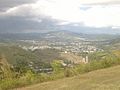
Cayey landscape from PR-52
.jpg)
.jpg)


See also
 In Spanish: Cayey para niños
