
Río Grande de Loíza facts for kids
Quick facts for kids Grande de Loíza |
|
|---|---|

Loiza River mouth.
|
|
| Commonwealth | Puerto Rico |
| Municipality | San Lorenzo, Gurabo, Caguas, Trujillo Alto, Carolina, Loíza |
| Physical characteristics | |
| Main source | Sierra de Cayey in Espino, San Lorenzo, Puerto Rico 2,051 feet (625 m) |
| River mouth | Atlantic Ocean between Torrecilla Baja and Loíza, Loíza, Puerto Rico 0 ft (0 m) |
| Length | 64 km (40 mi) |
| Basin features | |
| Tributaries |
|
The Río Grande de Loíza is a very important river in Puerto Rico. It is known as the "Great River of Loíza" and is the largest river on the island by how much water it carries. It flows from the southern mountains all the way to the Atlantic Ocean on the north coast, just a bit east of San Juan.
This river is about 40 miles (64 kilometers) long. It starts high up in the mountains of San Lorenzo, around 3,500 feet (1,067 meters) above sea level. As it travels, it passes through many towns like Caguas, Gurabo, and Loíza. Along its path, it forms the beautiful Loíza Lake. This makes it the second longest river in Puerto Rico.
Contents
River's Journey: Where Does It Flow?
The area that the Río Grande de Loíza collects water from is called its drainage basin. This basin is the biggest in Puerto Rico, covering about 290 square miles (750 square kilometers). The river begins in the Espino area of San Lorenzo, Puerto Rico. This spot is on the eastern side of the Sierra de Cayey mountains, near the Carite State Forest.
As the river flows, it moves northeast through a hilly area with volcanic rocks. Here, smaller rivers like the Emajagua and Cayaguas join it. Then, the river turns northwest towards the Caguas Valley. Many other rivers and creeks, such as the Turabo and Gurabo, add their water here.
North of this valley, the river is stopped by the Carraízo Dam. This dam creates Loíza Lake, also known as Carraízo Lake. This lake is a very important source of drinking water for the area. Finally, the river reaches the big city area of San Juan and flows into the Atlantic Ocean.
River's Past: A Look at History
The Río Grande de Loíza has been important for a long time. Many towns and cities, like San Lorenzo, Caguas, and Trujillo Alto, were built along its banks. This shows how vital the river was for people to live and grow.
In 1898, the U.S. Military wrote about the river. They noted that it starts in the northern part of the Sierra de Cayey mountains. They also mentioned that for the first half of its journey, it was sometimes called the Cayagua. The famous Puerto Rican poet Julia de Burgos even wrote a beautiful poem about this river.
More recently, in 2018, the United States Army Corps of Engineers started a big project. They planned to spend $250 million to help control flooding from the river. This project helps protect the towns and people living near the river from heavy rains and storms.
Images for kids
-
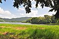
View of the river in Carraízo, Trujillo Alto close to the reservoir.
-
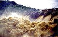
Flooding of the Loíza River's dam during Hurricane Hortense.
-
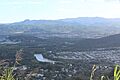
Loíza River in the Caguas Valley.
-
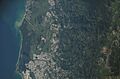
View of the Loíza River in Puerto Rico's northeastern plains from the International Space Station.


See also
 In Spanish: Río Grande de Loíza para niños
- Puente de Trujillo Alto: A historic bridge in Trujillo Alto, Puerto Rico.
- List of rivers of Puerto Rico
