
Trujillo Alto, Puerto Rico facts for kids
Quick facts for kids
Trujillo Alto
Municipio Autónomo de Trujillo Alto
|
|||
|---|---|---|---|
|
Town and Municipality
|
|||
| Santa Cruz de Trujillo | |||
|
Trujillo Alto town sign on Trujillo Alto Expressway
Trujillo Alto Bridge
Trujillo Alto City Hall
Lourdes Grotto
|
|||
|
|||
| Nicknames:
Ciudad de los Manantiales,
El Pueblo de las Ocho Calles, La Ciudad En El Campo, Los Arrecostaos |
|||
| Anthem: "Duerme Mi Lindo Trujillo" | |||

Map of Puerto Rico highlighting Trujillo Alto Municipality
|
|||
| Sovereign state | |||
| Commonwealth | |||
| Founded | January 8, 1801 | ||
| Barrios | |||
| Area | |||
| • Total | 21.47 sq mi (55.61 km2) | ||
| • Land | 21 sq mi (55 km2) | ||
| • Water | 0.24 sq mi (.61 km2) | ||
| Elevation | 69 ft (21 m) | ||
| Population
(2020)
|
|||
| • Total | 75,243 | ||
| • Rank | 10th in Puerto Rico | ||
| • Density | 3,504.4/sq mi (1,353.05/km2) | ||
| Demonym(s) | Trujillanos | ||
| Time zone | UTC−4 (AST) | ||
| ZIP Codes |
00976, 00977, 00978
|
||
| Area code(s) | 787/939 | ||
| Major routes | |||


Trujillo Alto (pronounced troo-HEE-yoh AHL-toh) is a town and municipality in Puerto Rico. It is located on the northeastern coast, near the boundary between the Northern Karst Belt and Sierra de Luquillo mountains. Trujillo Alto is south of Caguas and Gurabo, southeast of San Juan, and west of Carolina.
This town is part of the larger San Juan metropolitan area. Trujillo Alto is divided into 6 main areas called barrios, plus its downtown administrative center, known as Trujillo Alto Pueblo.
Trujillo Alto was officially started in 1801. It became more important in the 1900s because it is so close to San Juan, the capital. This closeness has made it a growing suburb. Its population has grown a lot, from 9,576 people in 1930 to 74,482 in 2010. In 2010, it was the tenth most populated municipality in Puerto Rico.
In 1953–54, the Carraízo hydroelectric dam was built here. This dam created the Loíza Lake, which is a large reservoir. This lake is the main source of drinking water for the city of San Juan.
Contents
History of Trujillo Alto
The area where Trujillo Alto is today was once part of the Taíno region called Cayniabón. This region stretched from the northeast coast of Puerto Rico to the center of the island. A leader named Cacique Canobaná ruled this area. Scientists have found two important ancient sites in Trujillo Alto: Las Cuevas and Quebrada Grande.
After the Spanish arrived, families began to settle on both sides of the Río Grande de Loíza. In the 1600s, the Spanish king gave a large ranch to Alonso Pizarro Hermona, who came from Trujillo, Spain. People started calling the area by his family name.
Eventually, the people living there asked the Governor for permission to build a chapel. Building a chapel was a necessary step to officially start a town. Even though there was some disagreement, Trujillo Alto was founded on January 8, 1801. Its first official name was Municipio La Santa Cruz de Trujillo. The town was built on a bend of the Río Grande de Loíza river. Around 1820, the name Trujillo Alto was used to tell it apart from Trujillo Bajo, which later became Carolina.
In 1826, travel to and from the town got easier. Two bridges were built, one leading to Río Piedras and another to Río Grande. By 1844, Trujillo Alto had only five main areas, called barrios. A few years later, the first school was built. Sadly, during this time, many people died because of a cholera sickness.
In 1898, Puerto Rico became a territory of the United States after Spain gave it up. In 1899, the U.S. Department of War counted the people in Puerto Rico for the first time. They found that Trujillo Alto had 5,683 residents.
In 1902, the Legislative Assembly of Puerto Rico passed a law to combine some towns. Because of this, Trujillo Alto became part of the nearby town of Carolina. But in 1905, the law was changed, and Trujillo Alto became its own municipality again.
In 1952, a water filtration plant was built in the Cuevas barrio of Trujillo Alto. This was built along with the Carraízo Dam in the Carraízo barrio.
Because Trujillo Alto is so close to the capital, San Juan, it grew and developed a lot during the 1900s. Its population increased greatly. In 2010, it was the tenth most populated city in Puerto Rico. The mayor, José Luis Cruz Cruz, who started serving in 2009, has called the city "The New Metropolis."
On September 20, 2017, Hurricane Maria hit Trujillo Alto. The heavy rain and strong winds caused many landslides. Almost all of Trujillo Alto's electricity went out, leaving nearly 75,000 people without power. Also, 90% of the residents lost access to clean drinking water.
Geography and Water Features

Trujillo Alto is located in the Northern Coastal Plain region of Puerto Rico. It shares borders with the municipalities of San Juan, Carolina, Gurabo, and Caguas. Trujillo Alto is a small municipality, covering about 21.47 square miles (55.6 square kilometers).
The land in Trujillo Alto is mostly flat in the north. The southern part has small hills, which can be from 660 to 1,600 feet (200–500 meters) above sea level.
Rivers and Lakes
Trujillo Alto's water system mainly includes the Río Grande de Loíza, which flows through the municipality. There are also several smaller streams, such as Colorada, Infierno, Limones, Naranjo, Grande, Pastrana, Haya Fría, and Maracuto.
Trujillo Alto is also home to Puerto Rico's most important water reservoir: The Carraízo Dam and the Loíza Lake. Both were built in 1953 by the Puerto Rico Aqueducts and Sewers Authority (PRASA). The dam was first built to create electricity, but now it is only used to supply public drinking water. People also use Loíza Lake for water sports and fishing.
Barrios of Trujillo Alto

Like all municipalities in Puerto Rico, Trujillo Alto is divided into areas called barrios. The main town buildings, central square, and large Catholic church are in the barrio known as "el pueblo".
- Carraízo
- Cuevas
- Dos Bocas
- La Gloria
- Quebrada Grande
- Quebrada Negrito
- St. Just
- Trujillo Alto barrio-pueblo
The layout of Trujillo Alto is quite simple. Most of the barrios are in the countryside parts of the city. The downtown area (Trujillo Alto Pueblo) is small, with only eight main streets. This is why the city is sometimes called the "City of the Eight Streets." There are no tall buildings or skyscrapers here.
Local Communities
Barrios are further divided into smaller areas called sectores (sectors). These sectors can have different names like urbanización, reparto, barriada, or residencial.
Some communities in Trujillo Alto are known as Comunidades Especiales de Puerto Rico (Special Communities of Puerto Rico). These are areas where people might face challenges like social exclusion. In 2014, some of these communities in Trujillo Alto included San Nicolás, Bethania, Comunidad Talanco, El Hoyo II, El Resbalón, Parcelas Carraízo, Parcelas Ramón T. Colón, Sector Arayanes, Sector La Prá, Sector Las Cruces, Sector Los Nuñez, Villa Escondida, Villa Margarita, and Villa Platanal.
Climate and Weather
| Climate data for Trujillo Alto, Puerto Rico (1991–2020 normals, extremes 1957–present) | |||||||||||||
|---|---|---|---|---|---|---|---|---|---|---|---|---|---|
| Month | Jan | Feb | Mar | Apr | May | Jun | Jul | Aug | Sep | Oct | Nov | Dec | Year |
| Record high °F (°C) | 96 (36) |
95 (35) |
95 (35) |
98 (37) |
99 (37) |
103 (39) |
97 (36) |
95 (35) |
102 (39) |
97 (36) |
101 (38) |
97 (36) |
103 (39) |
| Mean daily maximum °F (°C) | 83.4 (28.6) |
84.2 (29.0) |
85.0 (29.4) |
86.4 (30.2) |
87.5 (30.8) |
89.1 (31.7) |
89.2 (31.8) |
89.4 (31.9) |
89.8 (32.1) |
88.8 (31.6) |
86.6 (30.3) |
84.1 (28.9) |
87.0 (30.6) |
| Daily mean °F (°C) | 75.2 (24.0) |
75.4 (24.1) |
76.0 (24.4) |
77.5 (25.3) |
79.2 (26.2) |
80.8 (27.1) |
81.0 (27.2) |
81.2 (27.3) |
81.3 (27.4) |
80.6 (27.0) |
78.6 (25.9) |
76.2 (24.6) |
78.6 (25.9) |
| Mean daily minimum °F (°C) | 67.0 (19.4) |
66.5 (19.2) |
66.9 (19.4) |
68.6 (20.3) |
71.0 (21.7) |
72.4 (22.4) |
72.8 (22.7) |
73.0 (22.8) |
72.9 (22.7) |
72.4 (22.4) |
70.7 (21.5) |
68.2 (20.1) |
70.2 (21.2) |
| Record low °F (°C) | 55 (13) |
55 (13) |
52 (11) |
52 (11) |
54 (12) |
62 (17) |
61 (16) |
61 (16) |
60 (16) |
56 (13) |
57 (14) |
53 (12) |
52 (11) |
| Average precipitation inches (mm) | 5.02 (128) |
3.28 (83) |
3.67 (93) |
5.92 (150) |
6.88 (175) |
4.53 (115) |
7.11 (181) |
7.53 (191) |
8.50 (216) |
7.60 (193) |
7.92 (201) |
5.04 (128) |
73.00 (1,854) |
| Average precipitation days (≥ 0.01 in) | 16.4 | 11.3 | 10.9 | 11.8 | 13.7 | 10.3 | 15.1 | 14.9 | 14.2 | 15.5 | 17.6 | 17.2 | 168.9 |
| Source: NOAA | |||||||||||||
Fun Things to Do in Trujillo Alto
Trujillo Alto has several interesting places for visitors.
- The Bicentenary Walkway is at the entrance to the city on PR-181. It features a beautifully restored historic steel bridge, which was one of the first permanent crossings over the Grande de Loiza River. There's also a gazebo there. It was built in 2001 to celebrate Trujillo Alto's 200th birthday.
- Also on the PR-181 is the Luis Muñoz Marín Foundation. This foundation was started in 1980 and includes a museum, a historical archive, and a park.
- The Carraízo Dam and the Loíza Lake reservoir are popular spots to visit.
- Other interesting places include the Carmelitas de San José Convent, the Lourdes Grotto, and the Trujillo Alto Mountain Spring.
Economy and Jobs
Historically, Trujillo Alto's economy depended mostly on farming. They grew crops like sugarcane, coffee, tobacco, and various fruits. Raising cattle was also important. In recent years, businesses and factories have become a big part of the city's economy. Trujillo Alto has factories that make food products, wood items, metal goods, and electrical machines. There are also stone quarries that produce materials for building.
In 2013, Trujillo Alto had a low unemployment rate of 10.2%. This made it the second municipality in Puerto Rico with the lowest unemployment, after Guaynabo.
Culture and Traditions
Festivals and Events
Trujillo Alto celebrates its patron saint festival in September. The Fiestas Patronales de Santa Cruz is a religious and cultural event. It usually includes parades, games, local crafts, fun rides, traditional food, and live music.
The Festival Trujillano de Orquídeas (Orchid Festival) has been held every July since 2011. It is a competition and festival where beautiful orchids are judged, shown, and sold.
The Festival del Macabeo (Macabeo Festival) celebrates a special food from Trujillo Alto. It happens every year around the second week of December.
Other festivals in Trujillo Alto include an agricultural fair in January and a Paso Fino horse festival in November.
In 2001, Trujillo Alto celebrated its 200th anniversary. They opened a new park on the PR-181 and improved the historic steel bridge.
Religion and Faith

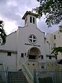
Trujillo Alto has many churches and chapels from different Christian groups. The main Catholic church, Santa Cruz Church, was built in 1817. Part of an older building was damaged by Hurricane San Felipe in 1928. The church you see today was designed by Luis Perocier and built in 1933.
Trujillo Alto is also a special place for Catholics because of a shrine to Our Lady of Lourdes that was blessed in 1925. The site has a grotto (a cave-like structure) dedicated to Our Lady of Lourdes. Many religious people and tourists visit the Gruta de Lourdes. There is also a convent in Trujillo Alto called the Convento Carmelitas de San José.
Sports and Recreation
Trujillo Alto does not have a professional sports team. However, it has several sports facilities for amateur and local teams. In 2011, the Rubén Sánchez Montañez Court in Trujillo Alto hosted the Cangrejeros de Santurce basketball team. This team plays in the Baloncesto Superior Nacional (BSN), which is Puerto Rico's professional basketball league. The court can hold 2,250 people.
Every September, Trujillo Alto holds the Arrecosta'o Marathon. This is one of the most important events in the city. The race has been held every year since 1985. It used to be 6.2 miles (10 kilometers) long, but in 2007, it was shortened to 3.1 miles (5 kilometers). In 2010, the marathon was recognized as one of the best organized events of the year.
Loíza Lake is also a popular place for fishing and other water activities. The lake has many types of fish, including largemouth bass, peacock bass, sea chubs, tilapia, and beardfish.
Local Food
The macabeo is the most famous traditional food from Trujillo Alto. It is a fried dish made from plantains and meat. This dish is so popular that a festival is held every year to celebrate it. The Macabeo Festival started in the early 1980s and takes place every December.
Population Changes
| Historical population | |||
|---|---|---|---|
| Census | Pop. | %± | |
| 1900 | 5,683 | — | |
| 1910 | 6,345 | 11.6% | |
| 1920 | 7,470 | 17.7% | |
| 1930 | 9,576 | 28.2% | |
| 1940 | 11,726 | 22.5% | |
| 1950 | 13,605 | 16.0% | |
| 1960 | 18,251 | 34.1% | |
| 1970 | 30,669 | 68.0% | |
| 1980 | 51,389 | 67.6% | |
| 1990 | 61,120 | 18.9% | |
| 2000 | 75,728 | 23.9% | |
| 2010 | 74,842 | −1.2% | |
| 2020 | 67,740 | −9.5% | |
| U.S. Decennial Census 1899 (shown as 1900) 1910–1930 1930–1950 1960–2000 2010 2020 |
|||
The number of people living in Trujillo Alto grew steadily during the 1900s, up until the year 2000. From 2000 to 2010, the population decreased slightly by 1.2%. From 2010 to 2020, it decreased by 9.5%. Even with this decrease, in 2020, Trujillo Alto was still the tenth largest municipality in Puerto Rico by population, with 67,740 residents.
According to the 2010 Census, about 72% of the people in Trujillo Alto identified as White, and 14.6% as African-American. Also, 47.5% of the population were males, and 52.5% were females. About 25% of the population was under 18 years old. The next largest group, 20.7%, was between 35 and 49 years old.
Symbols of Trujillo Alto
The municipality has an official flag and a coat of arms.
The Flag
The flag of Trujillo Alto has a white background. In the center, it features the town's coat of arms.
The Coat of Arms
The coat of arms is a shield with a blue border. On the border, there are eight splashes of water. These represent the many springs, creeks, and rivers that flow through the town. Inside the shield, there is a silver area with three green mountains. Above the mountains is a blue Latin cross. The flag also has a white banner below the shield with the city's name. A coronet shaped like a five-tower mural crown sits on top, representing the Spanish crown. The banner and the coronet are not shown on the actual flag.
City Nicknames
Trujillo Alto is known by several nicknames:
- "City of Springs" because of its many rivers and streams.
- "Town of the Eight Streets" because its downtown area has only eight main streets.
- "City in the Country" because it is close to the San Juan Metropolitan Area but still feels like a mountain town.
- "Laid-back Town" (Los Arrecostaos).
Getting Around Trujillo Alto

The main road to Trujillo Alto is PR-181, which goes through the municipality from north to south. The capital, San Juan, is about 11 miles (18 kilometers) away, which takes about 15 minutes to drive. Other roads that lead to Trujillo Alto include PR-852 (from the Quebrada Grande and Dos Bocas neighborhoods), PR-175 (from the Carraízo neighborhood), Las Cumbres Avenue, and PR-851 (from the La Gloria neighborhood).
In the past, it was hard to get to the town because it was on the other side of the Río Grande de Loíza river. But in 1826, two bridges were built, which made travel much easier. In 1939, the United States Army built a steel bridge on PR-181 at the town's entrance. This bridge replaced one of the older ones. Even though cars don't use it anymore, it is still standing and has become a symbol of the city.
The northern part of Trujillo Alto is served by the Puerto Rico Metropolitan Bus Authority. There are several bus stops along PR-181 and in nearby neighborhoods. Other ways to get around the city include taxis and shared public cars.
Trujillo Alto has 11 bridges in total.
Famous People from Trujillo Alto
- Dariam Acevedo – An Olympic gold medalist in female beach volleyball for Puerto Rico in 1984.
- Jasmine Camacho-Quinn – An Olympic gold medalist in Women's 100m Hurdles in 2020. She could represent Puerto Rico because her mother is from Trujillo Alto.
- Tulio Larrínaga – An architect who worked on the city of San Juan in 1872.
- Yolandita Monge – A famous international singer, songwriter, actress, and TV personality.
- Irad Ortiz Jr – A champion jockey who has won over 3000 races in the USA. He won the Eclipse Award for outstanding jockey three times in a row (2018, 2019, 2020).
- Jose Ortiz – A champion jockey who has won over 2300 races in the USA. He won the Eclipse Award for outstanding jockey in 2017.
Images for kids
-
Parroquia Santa Cruz in Trujillo Alto Pueblo, 2007

See also
 In Spanish: Trujillo Alto para niños
