
Gurabo, Puerto Rico facts for kids
Quick facts for kids
Gurabo
Municipio de Gurabo
|
|||
|---|---|---|---|
|
Town and municipality
|
|||

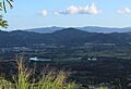
Gurabo River and valley from Jaguas.
|
|||
|
|||
| Nicknames:
El Pueblo de las Escaleras", "Puerta del Turismo del Sureste
|
|||
| Anthem: "En un valle rodeado por montañas nace un" | |||

Map of Puerto Rico highlighting Gurabo Municipality
|
|||
| Sovereign state | |||
| Commonwealth | |||
| Settled | 1700 | ||
| Founded | November 27, 1815 | ||
| Founded by | Luis del Carmen Echevarría | ||
| Barrios | |||
| Area | |||
| • Total | 28.28 sq mi (73.24 km2) | ||
| • Land | 27.84 sq mi (72.11 km2) | ||
| • Water | 0.44 sq mi (1.13 km2) | ||
| Population
(2020)
|
|||
| • Total | 40,622 | ||
| • Rank | 21st in Puerto Rico | ||
| • Density | 1,436.52/sq mi (554.64/km2) | ||
| Demonym(s) | Gurabeños | ||
| Time zone | UTC-4 (AST) | ||
| ZIP Code |
00778
|
||
| Area code(s) | 787/939 | ||
| Major routes | |||
| Website | gurabopr.com | ||


Gurabo (Spanish pronunciation: [ɡuˈɾaβo]) is a town and municipality located in eastern Puerto Rico. It is in the central eastern part of the island. Gurabo is north of San Lorenzo, south of Trujillo Alto, east of Caguas, and west of Carolina and Juncos. The municipality includes 9 main areas called barrios, plus the downtown area known as Gurabo Pueblo. It is also part of the larger San Juan-Caguas-Guaynabo Metropolitan Statistical Area.
Contents
History of Gurabo
Gurabo's story began in the 1600s. Back then, it was part of Caguas and was known as Burabo. By the 1700s, people in Burabo found it hard to travel to Caguas for business or medical help. This made many residents want their own separate town.
It took a long time for Gurabo to become its own municipality. In 1812, 168 family leaders in Burabo met and chose Luis del Carmen Echevarría to lead their effort for independence. They felt they had enough people to form their own town.
In 1815, Gurabo officially became a municipality. The first Catholic church was built in 1822. Later, in 1903, the first Baptist church opened in Gurabo town.
Gurabo is also known as "La Ciudad de las Escaleras", which means "The City of Stairs". In the El Cerro area of town, there are tall stairs, about twenty-two floors high. These stairs are painted in bright, colorful designs.
The current mayor of Gurabo is Rosachely Rivera Santana. In September 2017, Hurricane Maria brought a lot of rain to Gurabo. This caused many landslides and floods. Many people needed help, and some homes were damaged.
Geography and Nature
Gurabo is located on the eastern side of Puerto Rico, within the Caguas Valley.
Rivers and Waterways
Gurabo has several rivers, streams, and small creeks. The main river flowing through the municipality is the Gurabo River. A part of the Loíza River also runs through Gurabo. In 2018, the U.S. Army Corps of Engineers announced plans to work on the Gurabo River.
Gurabo's Barrios

Like all municipalities in Puerto Rico, Gurabo is divided into areas called barrios. The main town area, with its government buildings, central square, and large Catholic church, is called "el pueblo".
Smaller Areas: Sectors
Barrios are further divided into smaller areas called sectores (which means sectors in English). These sectors can have different names, like urbanización or residencial.
Special Communities in Gurabo
Comunidades Especiales de Puerto Rico (Special Communities of Puerto Rico) are neighborhoods where people might face challenges. In 2014, some of these communities in Gurabo included El Cerro, Estancias de Hato Nuevo, and Villa Alegre.
Gurabo's Climate
| Climate data for Gurabo, Puerto Rico (1991–2020 normals, extremes 1956–present) | |||||||||||||
|---|---|---|---|---|---|---|---|---|---|---|---|---|---|
| Month | Jan | Feb | Mar | Apr | May | Jun | Jul | Aug | Sep | Oct | Nov | Dec | Year |
| Record high °F (°C) | 97 (36) |
93 (34) |
99 (37) |
99 (37) |
97 (36) |
96 (36) |
97 (36) |
97 (36) |
103 (39) |
96 (36) |
98 (37) |
96 (36) |
103 (39) |
| Mean daily maximum °F (°C) | 84.5 (29.2) |
84.7 (29.3) |
86.3 (30.2) |
87.5 (30.8) |
88.8 (31.6) |
90.1 (32.3) |
90.2 (32.3) |
90.8 (32.7) |
90.4 (32.4) |
89.5 (31.9) |
87.6 (30.9) |
85.3 (29.6) |
88.0 (31.1) |
| Daily mean °F (°C) | 73.2 (22.9) |
73.1 (22.8) |
74.4 (23.6) |
76.5 (24.7) |
78.9 (26.1) |
80.2 (26.8) |
80.0 (26.7) |
80.7 (27.1) |
80.2 (26.8) |
79.4 (26.3) |
77.3 (25.2) |
74.8 (23.8) |
77.4 (25.2) |
| Mean daily minimum °F (°C) | 61.8 (16.6) |
61.4 (16.3) |
62.6 (17.0) |
65.5 (18.6) |
69.0 (20.6) |
70.4 (21.3) |
69.8 (21.0) |
70.6 (21.4) |
70.1 (21.2) |
69.2 (20.7) |
67.0 (19.4) |
64.3 (17.9) |
66.8 (19.3) |
| Record low °F (°C) | 43 (6) |
42 (6) |
43 (6) |
51 (11) |
50 (10) |
55 (13) |
54 (12) |
54 (12) |
58 (14) |
55 (13) |
53 (12) |
50 (10) |
42 (6) |
| Average precipitation inches (mm) | 3.72 (94) |
2.64 (67) |
3.88 (99) |
4.21 (107) |
5.38 (137) |
3.83 (97) |
5.93 (151) |
8.22 (209) |
8.72 (221) |
6.95 (177) |
6.98 (177) |
4.31 (109) |
64.77 (1,645) |
| Average precipitation days (≥ 0.01 in) | 20.3 | 17.1 | 14.1 | 15.1 | 17.5 | 16.5 | 17.3 | 18.6 | 18.6 | 18.2 | 20.9 | 20.5 | 214.7 |
| Source: NOAA | |||||||||||||
Economy and Industry
Agriculture in Gurabo
- Dairy farms are an important part of Gurabo's agriculture.
Local Industries
Gurabo has many factories. These factories make things like metal products, paper, plastics, chemicals, medicines, and electronic equipment.
Tourism and Landmarks
To help people discover local attractions, the Puerto Rico Tourism Company created the Voy Turistiendo ("I'm Touring") campaign. This campaign includes a passport book and a website. The Gurabo page lists several interesting places to visit.
Places to Visit in Gurabo
Some popular landmarks and places to see in Gurabo include:
- Centro de Exposición - This is an Exhibition Center.
- El Cerro - Home to the famous colorful stairs.
- The Former City Hall and its Clock.
- Church of San José - A historic church.
- Luis Muñoz Marín Plaza - This is the main square in the downtown area.
- Hacienda Mirador - A beautiful estate.
- University of Turabo Museum - A museum located at the university.
- Cofresí Park - A local park.
Culture and Events
Festivals and Celebrations
Gurabo celebrates its patron saint festival in March. This event is called the Fiestas Patronales de San Jose. It is a religious and cultural celebration. You can usually find parades, games, local crafts, fun rides, traditional food, and live entertainment.
Other festivals and events in Gurabo include:
- El Festival del Jodío - This festival roughly translates to the "Festival of the person who is down on their luck". It helps people in the community who have serious medical needs by collecting funds. The seventh annual fair was held in May 2017.
- Home Garden Festival (May)
- Youth Festival (May)
- Mapeyé Festival (October)
Sports in Gurabo
Gurabo is home to the Puerto Rico Baseball Academy and High School (PRBAHS). This academy helps young baseball players develop their skills.
Colegio Bautista de Gurabo also offers various sports. These include Volleyball, Soccer, Basketball, Softball, and Track and Field. You can find more information at colegiobautistadegurabo.com.
Population of Gurabo
| Historical population | |||
|---|---|---|---|
| Census | Pop. | %± | |
| 1900 | 8,700 | — | |
| 1910 | 11,139 | 28.0% | |
| 1920 | 12,882 | 15.6% | |
| 1930 | 15,095 | 17.2% | |
| 1940 | 15,870 | 5.1% | |
| 1950 | 16,395 | 3.3% | |
| 1960 | 16,603 | 1.3% | |
| 1970 | 18,289 | 10.2% | |
| 1980 | 23,574 | 28.9% | |
| 1990 | 28,737 | 21.9% | |
| 2000 | 36,743 | 27.9% | |
| 2010 | 45,369 | 23.5% | |
| 2020 | 40,622 | −10.5% | |
| U.S. Decennial Census 1899 (shown as 1900) 1910-1930 1930-1950 1960-2000 2010 2020 |
|||
In 2000, Gurabo had a population of 36,743 people. By 2010, the population grew to 45,369. In 2020, the population was 40,622.
Transportation in Gurabo
There are 20 bridges located in Gurabo.
Symbols of Gurabo
The municipality of Gurabo has its own official flag and coat of arms.
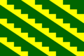
Gurabo's Flag
The flag has eleven stripes. Six of these stripes are green, and five are yellow. The yellow stripes have an indented top edge, which looks like a stairway.
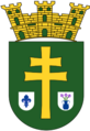
Gurabo's Coat of Arms
The coat of arms has a green background. On it, there is a wide gold cross. Below the bottom part of the cross, there are two silver shields. The shield on the left has a fleur de lis. The shield on the right has three lilies with their stems. Three gold towers sit on top of the main shield.
Education in Gurabo
- Ana G. Mendez University, Gurabo campus is located in Navarro.
- The Puerto Rico Criminal Justice College also has a campus in Gurabo. This is where the Puerto Rico Police Academy is located.
Images for kids
-
Gurabo River and valley from Jaguas.
-
Flag of Gurabo.
-
Coat of arms of Gurabo.
-

Map of Puerto Rico highlighting Gurabo Municipality.
-

Gurabo map with barrio subdivisions.
See also
 In Spanish: Gurabo (Puerto Rico) para niños
