Navarro, Gurabo, Puerto Rico facts for kids
Quick facts for kids
Navarro
|
|
|---|---|
|
Barrio
|
|

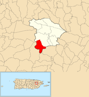
Location of Navarro within the municipality of Gurabo shown in red
|
|
| Commonwealth | |
| Municipality | |
| Area | |
| • Total | 2.81 sq mi (7.3 km2) |
| • Land | 2.78 sq mi (7.2 km2) |
| • Water | 0.03 sq mi (0.08 km2) |
| Elevation | 262 ft (80 m) |
| Population
(2010)
|
|
| • Total | 10,561 |
| • Density | 3,798.9/sq mi (1,466.8/km2) |
| Source: 2010 Census | |
| Time zone | UTC−4 (AST) |
| ZIP Code |
00778
|
Navarro is a neighborhood, called a barrio, located in the town of Gurabo, Puerto Rico. In 2010, about 10,561 people lived there. It's a part of Puerto Rico, which is a commonwealth of the United States.
Contents
Puerto Rico became a part of the United States after the Spanish–American War in 1898. This happened because of an agreement called the Treaty of Paris of 1898. After this, Puerto Rico became an unincorporated territory of the United States. This means it's a territory that belongs to the U.S. but isn't a state.
Early Population Counts
In 1899, the United States Department of War took a special count of all the people in Puerto Rico. This count is called a census. They found that the combined population of Navarro and another nearby barrio called Quebrada Infierno was 1,093 people.
| Historical population | |||
|---|---|---|---|
| Census | Pop. | %± | |
| 1980 | 2,976 | — | |
| 1990 | 3,131 | 5.2% | |
| 2000 | 5,015 | 60.2% | |
| 2010 | 10,561 | 110.6% | |
| U.S. Decennial Census 1899 (shown as 1900) 1910-1930 1930-1950 1980-2000 2010 |
|||
What are Sectors?
Understanding Barrios and Sectors
In Puerto Rico, a barrio is like a large neighborhood or a small district. Think of it as a main area within a town. These barrios are then divided into even smaller local areas. These smaller areas are called sectores (which means sectors in English).
Different Types of Sectors
The names for these smaller sectores can be different. Some are just called sector. Others might be named urbanización (like a housing development), reparto (a land division), barriada (a settlement), or residencial (a residential complex).
Here are some of the different sectors you can find within the Navarro barrio:
- Alturas de Santa Bárbara
- Apartamentos Maga Tree Village
- Apartamentos Las Vistas de Gurabo
- Apartamentos Paseo Gran Vista
- College High
- Condominio El Alcázar
- Condominio Paseo Gales
- Condominio Ventanas de Gurabo
- Parcelas Navarro
- Reina de los Ángeles
- Sector Bruceles
- Sector Carlos Rivera
- Sector Cielito
- Sector Los Flamboyanes
- Sector Los Flores
- Sector Los Pinos
- Sector Los Solares
- Sector Mano Manca
- Sector Pachanga
- Sector Quebrada
- Sector Santa Bárbara
- Urbanización Alta Paz
- Urbanización Campiñas de Navarro
- Urbanización Colinas de Navarro
- Urbanización College Hills
- Urbanización El Convento
- Urbanización Estancias de Gran Vista
- Urbanización Estancias de Monte Verde
- Urbanización Estancias de Santa Bárbara
- Urbanización Gran Vista I
- Urbanización Gran Vista II
- Urbanización Horizontes
- Urbanización Las Lilas
- Urbanización Mansiones de Navarro
- Urbanización Mansiones de Santa Bárbara
- Urbanización Monte Alto
- Urbanización Monte Brisas
- Urbanización Monte Subasio
- Urbanización Paraíso de Santa Bárbara
- Urbanización Paseos de Santa Bárbara
- Urbanización Praderas de Navarro
- Urbanización Preciosa
- Urbanización Sabanera del Río
- Urbanización Santa Bárbara
- Urbanización Valle Santa Bárbara
- Urbanización Ventanas Al Valle
- Urbanización Vereda
- Valle Borikén
See also
 In Spanish: Navarro (Gurabo) para niños
- List of communities in Puerto Rico
- List of barrios and sectors of Gurabo, Puerto Rico
 | Dorothy Vaughan |
 | Charles Henry Turner |
 | Hildrus Poindexter |
 | Henry Cecil McBay |


