
Gurabo barrio-pueblo facts for kids
Quick facts for kids
Gurabo barrio-pueblo
Pueblo de Gurabo
|
|
|---|---|
|
Municipality Seat
|
|

Museo del Deporte in Gurabo barrio-pueblo
|
|

Location of Gurabo barrio-pueblo within the municipality of Gurabo shown in red
|
|

Gurabo barrio-pueblo
Location in Caribbean
|
|
| Commonwealth | |
| Municipality | |
| Area | |
| • Total | 0.11 sq mi (0.3 km2) |
| • Land | 0.11 sq mi (0.3 km2) |
| • Water | 0 sq mi (0 km2) |
| Elevation | 177 ft (54 m) |
| Population
(2010)
|
|
| • Total | 1,509 |
| • Density | 13,718.2/sq mi (5,296.6/km2) |
| Source: 2010 Census | |
| Time zone | UTC−4 (AST) |
| ZIP Code |
00778
|
Gurabo barrio-pueblo is a special part of Gurabo, a town in Puerto Rico. It's like the main downtown area or the heart of the town. This area is the administrative center, which means it's where the local government buildings are located. In 2010, about 1,509 people lived here.
In Puerto Rico, it's a tradition from Spain for each town to have a central area called a pueblo. This pueblo usually has a main plaza (a public square), the town hall, and a Catholic church. Many towns also hold special yearly festivals called Fiestas patronales in their central plaza.
Contents
The Heart of Gurabo: Plaza and Church
The central plaza in Gurabo barrio-pueblo is a lively spot. It's a place where people can relax, meet friends, and enjoy community events from morning until night. Long ago, Spanish laws called the Laws of the Indies guided how towns in Puerto Rico were built.
Designing the Central Plaza
These old Spanish laws said that the plaza should be "a good place for parties" (meaning celebrations and festivals). They also stated that the plaza should be big enough for all the people living nearby. The laws also suggested that streets around the plaza should have comfortable walkways. These walkways would protect people from the sun and rain.
The Historic Church of San José
Right across from the central plaza is the Church of San José. This Roman Catholic church first opened its doors in 1822. Over the years, strong hurricanes have sometimes damaged the church. But each time, it has been carefully repaired and made new again. The most recent restoration of the church was finished in 1989.
A Look Back: Gurabo's History
Puerto Rico became a territory of the United States after the Spanish–American War. This happened because of an agreement called the Treaty of Paris of 1898. In 1899, the U.S. government took a count of the people in Puerto Rico. This count, or census, showed that 1,309 people lived in Gurabo Pueblo at that time.
Population Changes Over Time
The number of people living in Gurabo barrio-pueblo has changed over the years. Here's a look at the population from different census counts:
| Historical population | |||
|---|---|---|---|
| Census | Pop. | %± | |
| 1900 | 1,309 | — | |
| 1970 | 1,982 | — | |
| 1980 | 1,982 | 0.0% | |
| 1990 | 1,922 | −3.0% | |
| 2000 | 1,960 | 2.0% | |
| 2010 | 1,509 | −23.0% | |
| U.S. Decennial Census 1899 (shown as 1900) 1910-1930 1930-1950 1980-2000 2010 |
|||
Exploring Gurabo's Sectors
Barrios, like Gurabo barrio-pueblo, are often divided into even smaller areas. These smaller areas are called sectores (which means sectors in English). The names for these sectors can be different. Some are simply called sector, while others might be urbanización, reparto, barriada, or residencial.
Famous Areas within Gurabo
In Gurabo barrio-pueblo, you can find several interesting sectors:
- Barriada Nueva
- Casco del Pueblo
- El Cerro
- Rabo del Buey
- Vietnam
One of the most well-known sectors is El Cerro. It's famous for its very steep roads and special step streets, which are like long staircases. Because of these unique streets, Gurabo is sometimes called Pueblo de las Escaleras, which means "town of the stairs."
Gallery
-
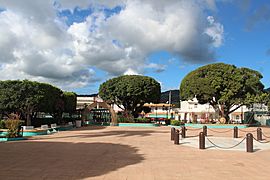
Plaza de Gurabo
-
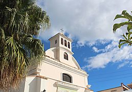
Church San José of Gurabo, listed on the National Register of Historic Places.
-
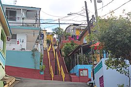
One of the famous step streets of El Cerro.
-
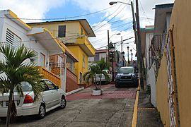
Steep streets in El Cerro.


See also
 In Spanish: Gurabo (Gurabo) para niños
- List of communities in Puerto Rico
- List of barrios and sectors of Gurabo, Puerto Rico
