
San Juan Bay facts for kids
Quick facts for kids San Juan Bay |
|
|---|---|

Mercator projection of San Juan Bay
|
|
| Lua error in Module:Location_map at line 420: attempt to index field 'wikibase' (a nil value). | |
| Location | San Juan, Puerto Rico |
| Type | Bay |
| Native name | Bahía de San Juan Error {{native name checker}}: parameter value is malformed (help) |
| Ocean/sea sources | North Atlantic Ocean |
| Managing agency | Department of Natural and Environmental Resources, Puerto Rico Ports Authority |
| Salinity | 34.5 |
San Juan Bay (Spanish: Bahía de San Juan) is a large water area next to Old San Juan in northeastern Puerto Rico. It is about 3.5 miles (5.6 km) long. This bay is part of a bigger water system called an estuary. This estuary covers about 97 square miles (251 km²) and includes channels, smaller inlets, and eight connected lagoons. San Juan Bay is home to Puerto Rico's busiest port, the Port of San Juan. Its history goes back to at least the year 1508.
Contents
Geography of San Juan Bay
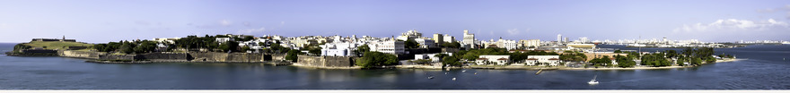
The bay is a body of water that is mostly closed off from the open ocean. It has many loops, wide areas, and channels. It is located near Puerto Rico's most important historical places and biggest cities. San Juan Bay is a great spot for fun activities like boating, sightseeing, and tourism. Its curved shape provides many places for boats to dock.
Because of new buildings and businesses, the bay's natural environment has been stressed. So, projects have started to help bring the estuary back to health. In 2015, the San Juan Estuary Program began using green flags. These flags show how clean the bay's waters are.
If you look at a map, San Juan Bay might seem like two lakes connected by a narrow part. This is because of a piece of land called Puntilla ("small point"). It sticks out from the Islet of San Juan Bautista into the middle of the bay. Another piece of land, Punta Cataño, stretches from the other side. This shows how uneven the bay's shape is.
Next to Puntilla are docks that are said to be the busiest in the Caribbean. These docks are part of the Port of San Juan. They are on the Islet of San Juan Bautista, near the entrance to San António Channel. Three bridges connect the islet to the mainland over this channel. The channel links the bay to Laguna del Condado (Condado Lagoon) and the Atlantic Ocean. One of these bridges is the old Bridge of Two Brothers. Before these bridges were built, Condado Lagoon was the narrowest way into the bay.
On the other side of the Isla Grande peninsula, the inside of the bay looks like a triangle. This area includes the busy Bahía de Puerto Nuevo (New Port Bay). This port is closer to roads and other ways to transport goods inland than the Port of San Juan. The bay gets its water from the Río Piedras river. This river flows into the bay through the Canal Martín Peña. This 3.75-mile (6.04 km) channel connects the bay to other lagoons and the city of Río Piedras.
History of San Juan Bay
Early European Settlement

When Spanish explorers, called conquistadors, came to the New World, they wanted to build cities. They didn't want to live on ships or in temporary camps. They needed strong homes, often with stone walls, like they had in Europe.
Juan Ponce de León was a Spanish explorer. He spent many days looking for the best place to build a villa, which was a plan for a new colonial city. The governor of Santo Domingo, Nicolás de Ovando, asked Ponce de León to explore and teach Christianity on a nearby island. Christopher Columbus had named this island "San Juan Bautista" on his second trip to the Americas. This island was a frontier, meaning it was a border area. People said that the Caribs who lived there were fierce. This was a chance for Ponce de León to show bravery and bring glory to Spain and God.
Following de Ovando's advice, Ferdinand II of Aragon made Ponce de León an adelantado. This meant he was given permission to conquer the Taíno island. The island's original name was Boriquén. It would be the second island in the Caribbean to become part of the Spanish Empire.
In 1508, Ponce de León sailed into the Bay of Guanica on the west side of the island. There, a local chief, or cacique, named Agüeybaná I, welcomed his men. But the Spanish did not find a good place to settle there. Ponce de León and his small team of noblemen, called hidalgos, traveled across the island. They found a large, almost-closed-off bay on the northeastern shore. No native people seemed to live in this area, maybe because it was often attacked by Caribs. Ponce de León named this body of water the Bay of the Wealthy Port (Spanish: Bahía de Puerto Rico).
.jpg)
Ponce de León moved inland and started the first Spanish settlement on the island. It was about 3 miles (4.8 km) from the bay. He named this settlement Caparra, as de Ovando had suggested. The explorer chose this spot because it was close to the sea and also near "gold mines and farms of the Toa Valley".
Caparra turned out to be a difficult place to live. Religious leaders asked Ponce de León to move the settlement closer to the bay. They said the sea breezes there would be healthier, and that the current location was dangerous for children. The governor did not want to move because he had built a house in Caparra.
In 1511, a new governor, Juan Cerón, was appointed. He received permission from the king to move the village. According to a map by Rodrigo de Figueroa, the villagers moved to a windy, wooded islet about three miles long at the bay's entrance. By 1521, the move was complete. They named the new village "Villa de Puerto Rico". A few years later, after the king gave it a higher status, it was renamed "Ciudad de Puerto Rico". Spanish engineers built walls and castles to protect the islet. They connected it to mainland Puerto Rico with the San Antonio Bridge. This is why it became known as "the walled city".
A Spanish historian from the 1500s, Bartolomé de las Casas, described the bay and its area with different names than we use today. He said the island was called "San Juan" by the Spanish, but "Boriquén" by the native people. He also said the harbor was called "Puerto-Rico". Over time, the island became known as Puerto Rico, and its harbor (and bay) became San Juan. The native name changed to Borinquen.
Colonial Period and Importance
Moving the village from Caparra to the bay did not fully protect the settlers from Carib attacks. The Caribs understood that European settlement was a threat to their way of life. They attacked the new settlement fiercely.
By the 1700s, the population on the islet had grown into the large City of San Juan. This growth was mostly because of the bay and its port. The city and the entrances to the bay were made stronger with defenses. The bay and its walls separated the Spanish people living there from the rest of the island's population. This helped create a social system called a casta.
For the last 500 years, the bay's most important job has been to connect Puerto Rico to the rest of the world. Ships from the Spanish treasure fleet linked the island colony to the larger Spanish colonial network. Because of its important location, the bay was often a target for pirate attacks. It was also a place where powerful empires would show off their military strength. On the east side of the bay's mouth, the Castillo San Felipe del Morro still stands guard over its narrow entrance.
San Juan Bay Today

The Port of San Juan, located on the islet at the bay's northern side, is one of the busiest ports in the Caribbean. Thousands of fishermen work in the bay's brackish waters, where fresh water mixes with salt water from the sea. San Juan Bay is beautiful and has many different kinds of plants and animals. This attracts tourists and offers many fun activities.
However, too much use of the bay has caused some of its natural resources to be damaged. The area is also at risk from earthquakes. A special project has worked to clean the bay's water. Now, the water is safe for people to touch. This project has also improved the city's coastal areas around the bay.
Gallery
-
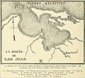
1922 sketch map
-

The Ciudad Amurallad (Walled City), seen from the bay
-
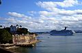
Cruise ship entering the bay
-
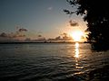
Sunset
-
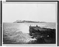
Narrow entrance, seen from the Isla de Cabras
-
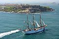
U.S. Coast Guard ship entering the bay
-
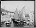
Sailboats in 1901
-
Bay entrance, seen from El Morro
-
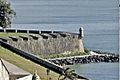
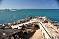
View from the city walls
-
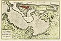
1766 map by Isaak Tirion


.jpg)


See also
 In Spanish: Bahía de San Juan (Puerto Rico) para niños
