
Mercator projection facts for kids


The Mercator projection is a special way to draw the Earth's curved surface onto a flat map. It's like trying to flatten an orange peel without tearing it! This map style was created by a smart mapmaker named Gerardus Mercator in 1569. Even today, it's one of the most common map types you'll see.
Imagine wrapping a cylinder (like a paper towel roll) around the Earth. The Mercator projection works by projecting the Earth's features onto this cylinder. Then, the cylinder is unrolled to make a flat map. This method is not a simple physical projection. It uses complex math to make sure certain things look right.
Contents
What is a Map Projection?
A map projection is a way to show the round Earth on a flat surface. Think of it like peeling an orange and trying to lay the peel flat. It's hard to do without stretching or squishing parts. All flat maps have some kind of distortion. This means they don't perfectly show the true size, shape, distance, or direction of places.
How the Mercator Map Works
The Mercator map is a type of cylindrical projection. This means it's made as if the Earth's surface is projected onto a cylinder. Then, that cylinder is unrolled into a flat map. One of the best things about the Mercator projection is that it keeps the shapes of small areas correct. This is called "conformity." So, if you look at a small island, its shape will look accurate on the map.
Why Mercator Maps are Useful
Mercator maps are super helpful for navigation, especially for sailors. On this map, a straight line drawn between two points shows a constant compass bearing. This means if a ship sails along that straight line, it will always be heading in the same compass direction. This makes it easy for sailors to plot their courses across oceans.
Understanding Map Distortions
While the Mercator projection is great for shapes and directions, it has a big downside. It distorts the size of landmasses, especially as you get closer to the North and South Poles. For example, on a Mercator map:
- Greenland looks huge, almost as big as Africa. But in reality, Africa is about 15 times larger than Greenland!
- Antarctica looks like a giant continent stretching across the entire bottom of the map. In reality, it's a much smaller, rounder landmass at the South Pole.
This happens because the map stretches out areas near the poles to make them fit the flat, rectangular shape.
Mercator Maps Today
Even with its size distortions, the Mercator projection is still widely used. You'll often see it in:
- School atlases
- Online mapping services
- Weather maps
- Navigational charts for ships and planes
It's important to remember that no flat map can perfectly show the Earth. Each map projection has its own strengths and weaknesses. The Mercator map is a powerful tool, especially for travel, but it's good to know its limitations too!
Images for kids
-
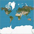
Mercator projection of the world between 85°S and 85°N. Notice how Greenland looks similar in size to Africa.
-
This animation shows how apparent size on the map compares to real size.
-
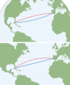
A rhumb line (blue) compared to a great-circle arc (red) between Lisbon, Portugal and Havana, Cuba. Top: orthographic projection. Bottom: Mercator projection.
-
.
Tissot's indicatrices on the Mercator projection show how distortion changes across the map.


See also
 In Spanish: Proyección de Mercator para niños
