
Guánica, Puerto Rico facts for kids
Quick facts for kids
Guánica
Municipio Autónomo de Guánica
|
||
|---|---|---|
|
Town and Municipality
|
||

Boats in San Jacinto Sector in Guánica barrio-pueblo
|
||
|
||
| Nicknames:
"Pueblo de la amistad", "El Pueblo de las Doce Calles", "Puerta de la Cultura"
|
||
| Anthem: "América es jardín del mundo" | ||

Map of Puerto Rico highlighting Guánica Municipality
|
||
| Country | ||
| Commonwealth | ||
| Settled | August 12, 1508 | |
| Founded | March 13, 1914 | |
| Barrios | ||
| Area | ||
| • Total | 53.42 sq mi (138.35 km2) | |
| • Land | 37 sq mi (96 km2) | |
| • Water | 16.35 sq mi (42.35 km2) | |
| Population
(2020)
|
||
| • Total | 13,787 | |
| • Rank | 71st in Puerto Rico | |
| • Density | 258.100/sq mi (99.653/km2) | |
| Demonym(s) | Guaniqueños | |
| Time zone | UTC−4 (AST) | |
| ZIP Codes |
00653, 00647
|
|
| Area code(s) | 787/939 | |
| Major routes | ||
| GNIS feature ID | 1610855 | |

Guánica is a town and municipality located in southern Puerto Rico. It sits right on the Caribbean Sea. To its north is Sabana Grande, to its east is Lajas, and to its west is Yauco. Guánica is part of the Yauco metropolitan area.
The main part of the municipality is called Guánica barrio-pueblo, also known as Pueblo de Guánica. In 2020, about 13,787 people lived here. Guánica is famous for its deep harbor, which looks like a tropical fjord. This harbor is narrow but stretches about 2 miles (3.2 km) from the sea to the town. Guánica is about 100 miles (160 km) from San Juan and 20 miles (32 km) west of Ponce.
Guánica's main ZIP Code is 00653. The nearby area of Ensenada has its own ZIP Code, 00647.
Contents
History of Guánica
Early Settlement
Juan Ponce de León arrived in the Guánica harbor on August 12, 1508. He started a town called Guaynía. This name comes from the Taíno language and means "Here is a place with water." This town was thought to be the first capital of Puerto Rico. Back then, the island was called Isla de San Juan Bautista.
However, the town was destroyed in 1511 during an uprising by the native people. Europeans then left the area for some years. During this time, San Juan became the island's capital.
Becoming a Municipality
After the Spanish–American War, Puerto Rico became a territory of the United States. In 1899, a census showed that Guánica had 2,700 people. The town of Guánica was first a part of Yauco. But on March 13, 1914, Guánica became its own separate municipality. Víctor Ángel Sallaberry Safini was the first mayor of Guánica.
The 1898 Invasion

On July 25, 1898, American forces landed in Guánica. This was part of the Puerto Rico campaign during the Spanish–American War. This invasion led to Puerto Rico becoming a part of the United States. The Americans chose Guánica because it had a safe harbor and was close to Ponce. It was also an unexpected place for an attack, unlike the heavily protected city of San Juan.
The ship Gloucester was the first to arrive in the Bay of Guánica. Twenty-eight sailors and Marines landed on the beach. They took down the Spanish flag and raised the American flag. They also set up defenses. The first fight between Puerto Rican soldiers and American forces happened when Lt. Méndez López and his men attacked the Americans. The Americans fired back, and the Gloucester also started shooting at the Spanish position. Lt. Méndez López and three of his men were hurt, and the Puerto Rican soldiers had to retreat.
A monument on the waterfront remembers this invasion. It is a large coral rock called the Guánica Rock (Piedra de Guánica). It has the words, "3rd Battalion, 1st U.S.V. Engineers, September 16, 1898." July 25 was once called Occupation Day in Puerto Rico. Now, it is known as Constitution Day.

Guánica Today

Guánica is a modern town that still keeps its traditional roots. It is known as el pueblo de la amistad ('the town of friendship'). It is also sometimes called el pueblo de las doce calles ('the town of the twelve streets'). The center of town has a grid of streets. There are five streets running north-south and seven running east-west. This creates a compact area with a main town square. The Catholic church, city hall, a school, and many shops face the square. The square itself has green areas, walkways, and a music stand.
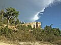
Hills surround the town and harbor. One hill to the east has the small Fort Caprón on top. Guánica is a fishing village, and commercial fishermen still work there. The Copamarina Beach Resort & Spa offers beach access. From there, you can take a short boat ride to Gilligan Island, which is great for snorkeling. The water is clear and shallow, and you can see coral and fish.
On September 20, 2017, Hurricane Maria hit Puerto Rico. In Guánica, 951 homes were damaged or destroyed. On January 6, 2020, a 5.8 magnitude earthquake shook Guánica. Many homes and cars were damaged. The next day, January 7, 2020, a stronger 6.4 magnitude earthquake hit the area.
Geography and Nature

Guánica has mountains and a special dry forest. The Guánica State Forest (Bosque Estatal de Guánica) is a dry forest reserve. It is the largest remaining tropical dry coastal forest in the world. It was named an international Biosphere Reserve in 1981. This park is also called Bosque Seco de Guánica.
Highway Route 116 is a main road nearby. It goes west towards Lajas and east towards Ponce. This road passes through the driest part of Puerto Rico. The Guánica Dry Forest is home to the most bird species on the island. Some birds found here are the Puerto Rican lizard cuckoo, Puerto Rican woodpecker, Puerto Rican nightjar, and Puerto Rican emerald hummingbird. Some animals once thought to be gone from Puerto Rico have been found here.
Many types of cacti grow in this forest. This is very different from the wet Caribbean National Forest in the northeast. That forest is a tropical rainforest. The difference is because of the mountain range called Cordillera Central. This mountain range separates Guánica from the northeast. The northeast gets over 100 inches (254 cm) of rain each year. But Guánica gets less than 30 inches (76 cm), and some parts of the forest get only six inches (15 cm).
The forest reserve covers about 9,500 acres (38 km²). It has 36 miles (58 km) of trails through four different forest types. These include trees that lose their leaves, a coastal area with tall milkweed and prickly pear cactus, a mahogany forest, and twisted gumbo limbo trees. There are about 700 types of plants, including aroma (acacia) and guayacan (also called 'wood of life'). One guayacan tree is about 500–700 years old!
You can also find the squat melon cactus and other cacti here. There are 40 species of birds, including the guabairo (Puerto Rican nightjar), which is found nowhere else. The Puerto Rico crested toad (Peltophryne lemur) also lives here. Sometimes, on the beaches, you might see green and leatherback turtles.
Barrios of Guánica

Like all municipalities in Puerto Rico, Guánica is divided into smaller areas called barrios. The main town buildings, central square, and large Catholic church are in a barrio called "el pueblo".
Special Communities
Some communities in Puerto Rico are called Comunidades Especiales de Puerto Rico (Special Communities of Puerto Rico). These are areas where people might face challenges in their daily lives. In Guánica, some of these communities include Esperanza neighborhood, Callejón Magüeyes, El Batey, El Tumbao, Ensenada, Fuig, La Luna, and Playa Santa.
Tourism in Guánica
 To help people explore Puerto Rico, the Puerto Rico Tourism Company created the Voy Turistiendo ("I'm Touring") campaign. Guánica is featured with places like Bosque Seco de Guánica (Guánica Dry Forest), Playa La Jungla (La Jungla Beach), and Cayo Aurora "Gilligan's" (Gilligan's Island).
Fun Places to Visit
Guánica has 39 beaches, including the popular Playa Santa. Here are some other interesting places:
- Guánica Parador 1929: A historic inn near an old sugar mill.
- Museum of Art and History of Guánica: This used to be the town hall.
- Azul Beach
- Ballenas Bay
- Ballenas Beach: Be careful, this beach is considered dangerous.
- Caprón Fortress
- Casa Alejada
- Cayo Aurora (also known as Gilligan's Island): A popular small island.
- Copamarina Beach Resort & Spa
- El Malecón (Boardwalk): A nice place to walk by the water.
- Guánica Bay
- Playa Manglillo: A beach near Playa Santa.
- Playa Santa Beach
- Punta de Brea: A good spot for surfing.
- Punta Jorobao
- Hacienda Santa Rita
- Serra Beach
- Central Guánica: An old sugar cane refinery.
- Guánica State Forest: Also called Guánica Dry Forest, it's a huge 9,000-acre (36 km²) forest.
- Guánica Lighthouse ruins: The remains of an old lighthouse.
Economy

Historically, Guánica's economy relied on:
- Agriculture: Salt and sugarcane were very important.
- Industry: There was also clothing manufacturing.
Culture and Events
Festivals and Events
Guánica celebrates its patron saint festival in July. This is called the Fiestas Patronales de Santiago Apostol. It's a religious and cultural event with parades, games, local crafts, rides, food, and live music. Famous artists have performed there.
Other festivals and events in Guánica include:
- Fish Festival – Held in April
- July 25 Parade – Held in July
- Juan Ponce de León Celebration – Held in August
Population
| Historical population | |||
|---|---|---|---|
| Census | Pop. | %± | |
| 1920 | 9,948 | — | |
| 1930 | 10,238 | 2.9% | |
| 1940 | 12,685 | 23.9% | |
| 1950 | 15,630 | 23.2% | |
| 1960 | 13,767 | −11.9% | |
| 1970 | 14,889 | 8.1% | |
| 1980 | 18,799 | 26.3% | |
| 1990 | 19,984 | 6.3% | |
| 2000 | 21,888 | 9.5% | |
| 2010 | 19,427 | −11.2% | |
| 2020 | 13,787 | −29.0% | |
| U.S. Decennial Census 1920-1930 1930-1950 1960-2000 2010 2020 |
|||
Symbols of Guánica
The municipality of Guánica has an official flag and a coat of arms.
Flag
The flag has five waves in blue and yellow. These waves represent the Guánica Bay. They are also a part of the official Shield of Guánica.
Coat of Arms
The shield is divided into four sections.
- The top right section shows a "bohío" (a native hut) under a crown. This represents Cacique Agüeybaná, a Taíno chief whose territory was in this area.
- The top left section has a lion, which represents Juan Ponce de León.
- The bottom right section has red and yellow checkered stripes on a silver background. These represent the shields of Don Cristóbal de Sotomayor, who founded the town of Tavara, where Guánica is now.
- The wavy stripes represent the bay of Guánica.
- Branches around the shield represent the sugarcane industry. This industry was very important to the region's history.
Famous People from Guánica
- Agüeybaná and Agüeybaná II: Important Taíno chiefs.
- Rose Franco (born 1932): The first Puerto Rican woman to become a Chief Warrant Officer in the U.S. Marine Corps.
Transportation
In 1937, Guánica used to have domestic flights from San Juan. These flights were operated by Puerto Rico's national airline, Puertorriqueña de Aviación.
Today, there are 25 bridges in Guánica.
Images for kids
-
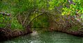
Guánica mangroves
-
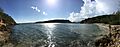
Playa Jaboncillo
-
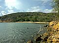
Playa Jaboncillo and Bosque Seco in Guánica
-
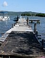
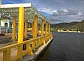
Pier in Guánica
-
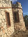
Fuerte Capron, Bosque Seco, Guánica
-
Fuerte Capron, Bosque Seco, Guánica
-
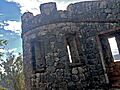
Facade of Fuerte Capron
-
Guánica boardwalk
-
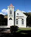
Adventist Temple in Guánica
.jpg)


Books About Guánica
- Torres, Angel Luis, Walter Torres, and Miguel Canals. En el Bosque Seco de Guánica. San Juan, Puerto Rico: La Editorial Universidad de Puerto Rico (Colección San Pedrito), 1995. ISBN: 0-8477-0207-3 – This is a children's picture book about a trip through the dry forest of Guánica with a sea turtle.
See also
 In Spanish: Guánica para niños
