Ciénaga, Guánica, Puerto Rico facts for kids
Quick facts for kids
Ciénaga
|
|
|---|---|
|
Barrio
|
|

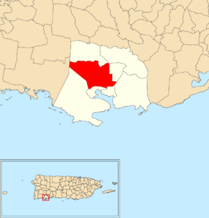
Location of Ciénaga within the municipality of Guánica shown in red
|
|
| Commonwealth | |
| Municipality | |
| Area | |
| • Total | 5.72 sq mi (14.8 km2) |
| • Land | 5.68 sq mi (14.7 km2) |
| • Water | 0.04 sq mi (0.1 km2) |
| Elevation | 52 ft (16 m) |
| Population
(2010)
|
|
| • Total | 2,231 |
| • Density | 392.8/sq mi (151.7/km2) |
| Source: 2010 Census | |
| Time zone | UTC−4 (AST) |
| ZIP Code |
00653
|
Ciénaga is a special area called a barrio in the beautiful island of Puerto Rico. It is part of the Guánica municipality. In 2010, about 2,231 people lived here.
What is a Barrio?
A barrio is like a neighborhood or a district. It is a way to divide up a municipality, which is similar to a county or a large town. Puerto Rico uses barrios to organize its different areas.
Where is Ciénaga Located?
Ciénaga is found in the southwestern part of Puerto Rico. It is close to the Caribbean Sea. The area is known for its warm weather and pretty landscapes.
How Many People Live Here?
The number of people living in Ciénaga has changed over the years. Here is a look at the population from different times:
| Historical population | |||
|---|---|---|---|
| Census | Pop. | %± | |
| 1930 | 1,074 | — | |
| 1940 | 1,145 | 6.6% | |
| 1950 | 1,358 | 18.6% | |
| 1980 | 2,002 | — | |
| 1990 | 1,967 | −1.7% | |
| 2000 | 2,376 | 20.8% | |
| 2010 | 2,231 | −6.1% | |
| U.S. Decennial Census 1899 (shown as 1900) 1910-1930 1930-1950 1980-2000 2010 |
|||
As you can see, the population grew quite a bit between 1930 and 2000. Then it went down a little by 2010.
See Also
- List of communities in Puerto Rico
 For more information in Spanish, check out: Ciénaga (Guánica) para niños
Black History Month on Kiddle
African-American Labor Activists
 | Bayard Rustin |
 | Jeannette Carter |
 | Jeremiah A. Brown |

All content from Kiddle encyclopedia articles (including the article images and facts) can be freely used under Attribution-ShareAlike license, unless stated otherwise. Cite this article:
Ciénaga, Guánica, Puerto Rico Facts for Kids. Kiddle Encyclopedia.

