
Lajas, Puerto Rico facts for kids
Quick facts for kids
Lajas
Municipio de Lajas
|
|||
|---|---|---|---|
|
Town and Municipality
|
|||

Homes in Lajas
|
|||
|
|||
| Nicknames:
"La Ciudad Cardenalicia", "Los Tira Piedras"
|
|||
| Anthem: "Nuestro Lajas, pueblito querido" | |||

Map of Puerto Rico highlighting Lajas Municipality
|
|||
| Sovereign state | |||
| Commonwealth | |||
| Settled | early 18th-century | ||
| Founded | April 3, 1883 | ||
| Founded by | Teodoro Jácome Pagán y Cancel and José Rodríguez y Rodríguez | ||
| Barrios | |||
| Area | |||
| • Total | 76.85 sq mi (199.04 km2) | ||
| • Land | 61 sq mi (158 km2) | ||
| • Water | 15.85 sq mi (41.04 km2) | ||
| Population
(2020)
|
|||
| • Total | 23,334 | ||
| • Rank | 53rd in Puerto Rico | ||
| • Density | 303.631/sq mi (117.233/km2) | ||
| Demonym(s) | Lajeños | ||
| Time zone | UTC−4 (AST) | ||
| ZIP Code |
00667
|
||
| Area code(s) | 787/939 | ||
| Major routes | |||
.svg)

Lajas (Spanish pronunciation: [ˈlaxas]) is a town and municipality in Puerto Rico. It is located in the Lajas Valley in the southwest of the island. Lajas is on the southern coast, next to the Caribbean Sea. It borders San Germán and Sabana Grande to the north. To its east is Guánica, and to its west is Cabo Rojo.
Lajas is divided into 11 areas called barrios, plus the downtown area known as Lajas Pueblo. It is part of the San Germán-Cabo Rojo Metropolitan Statistical Area.
Contents
History of Lajas
Lajas was founded in 1883 by Teodoro Jácome Pagán. Some of the first families to settle in the south of Puerto Rico came from Majorca, an island near Spain.
After the Spanish–American War, Puerto Rico was given to the United States in 1898. This happened under the Treaty of Paris of 1898. In 1899, a count of the population showed that 8,789 people lived in Lajas.
La Parguera is a popular place for tourists in Lajas. People visit to see the famous Bahía Fosforescente (Phosphorescent Bay). This bay is known for its glowing water and many small islands.
There's a fun local story about people from the El Combate area in Boquerón. They are called mata con hacha, meaning "those who kill with axes." This comes from a fight over salt flats, where people from Cabo Rojo used axes against people from Lajas. The people from Lajas fought back by throwing stones, so they are known as tira piedras, or "those who throw stones."
On September 20, 2017, Hurricane Maria hit Puerto Rico. In Lajas, more than 270 homes lost their roofs. The hurricane also destroyed the local pineapple farms.
Geography of Lajas

Lajas is located on the southern coast of Puerto Rico. The Laguna Cartagena National Wildlife Refuge is a protected natural area found in Lajas.
Barrios of Lajas

Like all parts of Puerto Rico, Lajas is divided into smaller areas called barrios. The main town center, with its government buildings and church, is in a barrio called "el pueblo".
Here are the barrios of Lajas:
- Candelaria
- Costa
- Lajas
- Lajas barrio-pueblo
- Lajas Arriba
- Llanos
- Palmarejo
- Parguera
- París
- Plata
- Sabana Yeguas
- Santa Rosa
Sectors in Barrios
Barrios are further divided into even smaller areas called sectores (sectors). These sectors can have different names like urbanización or barriada.
Climate in Lajas
Lajas has a tropical savanna climate. This means it's usually warm all year round. The highest temperature ever recorded in Lajas was 103 °F (39 °C).
| Climate data for Lajas Substation, Puerto Rico (1991–2020 normals, extremes 1900, 1950–present) | |||||||||||||
|---|---|---|---|---|---|---|---|---|---|---|---|---|---|
| Month | Jan | Feb | Mar | Apr | May | Jun | Jul | Aug | Sep | Oct | Nov | Dec | Year |
| Record high °F (°C) | 96 (36) |
94 (34) |
95 (35) |
95 (35) |
95 (35) |
99 (37) |
103 (39) |
99 (37) |
98 (37) |
97 (36) |
98 (37) |
98 (37) |
103 (39) |
| Mean maximum °F (°C) | 89.9 (32.2) |
89.9 (32.2) |
90.1 (32.3) |
91.1 (32.8) |
92.6 (33.7) |
94.4 (34.7) |
95.7 (35.4) |
95.1 (35.1) |
94.4 (34.7) |
93.9 (34.4) |
92.8 (33.8) |
91.1 (32.8) |
96.7 (35.9) |
| Mean daily maximum °F (°C) | 87.2 (30.7) |
87.2 (30.7) |
87.4 (30.8) |
88.4 (31.3) |
89.6 (32.0) |
91.3 (32.9) |
92.3 (33.5) |
91.8 (33.2) |
91.3 (32.9) |
90.8 (32.7) |
89.3 (31.8) |
88.2 (31.2) |
89.6 (32.0) |
| Daily mean °F (°C) | 74.7 (23.7) |
74.6 (23.7) |
75.4 (24.1) |
77.0 (25.0) |
79.2 (26.2) |
80.7 (27.1) |
81.1 (27.3) |
81.0 (27.2) |
80.7 (27.1) |
80.3 (26.8) |
78.3 (25.7) |
75.8 (24.3) |
78.2 (25.7) |
| Mean daily minimum °F (°C) | 62.2 (16.8) |
62.0 (16.7) |
63.4 (17.4) |
65.7 (18.7) |
68.8 (20.4) |
70.2 (21.2) |
70.0 (21.1) |
70.3 (21.3) |
70.1 (21.2) |
69.9 (21.1) |
67.2 (19.6) |
63.5 (17.5) |
66.9 (19.4) |
| Mean minimum °F (°C) | 55.1 (12.8) |
56.4 (13.6) |
57.7 (14.3) |
59.4 (15.2) |
63.0 (17.2) |
64.7 (18.2) |
65.1 (18.4) |
65.0 (18.3) |
63.7 (17.6) |
63.3 (17.4) |
60.4 (15.8) |
56.5 (13.6) |
53.2 (11.8) |
| Record low °F (°C) | 44 (7) |
51 (11) |
50 (10) |
50 (10) |
56 (13) |
55 (13) |
53 (12) |
58 (14) |
59 (15) |
56 (13) |
50 (10) |
49 (9) |
44 (7) |
| Average precipitation inches (mm) | 2.21 (56) |
2.29 (58) |
2.52 (64) |
3.27 (83) |
4.42 (112) |
2.19 (56) |
3.50 (89) |
4.87 (124) |
5.66 (144) |
6.34 (161) |
5.64 (143) |
2.00 (51) |
44.91 (1,141) |
| Average precipitation days (≥ 0.01 in) | 8.4 | 6.5 | 7.6 | 10.0 | 10.1 | 6.0 | 8.5 | 11.5 | 12.9 | 14.0 | 12.4 | 7.6 | 115.5 |
| Source: NOAA | |||||||||||||
| Climate data for Parguera, Puerto Rico (1991–2020 normals, extremes 1959–present) | |||||||||||||
|---|---|---|---|---|---|---|---|---|---|---|---|---|---|
| Month | Jan | Feb | Mar | Apr | May | Jun | Jul | Aug | Sep | Oct | Nov | Dec | Year |
| Record high °F (°C) | 92 (33) |
93 (34) |
95 (35) |
96 (36) |
97 (36) |
97 (36) |
100 (38) |
98 (37) |
101 (38) |
103 (39) |
95 (35) |
94 (34) |
103 (39) |
| Mean maximum °F (°C) | 88.6 (31.4) |
88.5 (31.4) |
89.2 (31.8) |
90.1 (32.3) |
90.0 (32.2) |
92.3 (33.5) |
92.7 (33.7) |
94.0 (34.4) |
94.4 (34.7) |
92.5 (33.6) |
91.5 (33.1) |
90.5 (32.5) |
96.8 (36.0) |
| Mean daily maximum °F (°C) | 86.0 (30.0) |
85.8 (29.9) |
85.7 (29.8) |
86.7 (30.4) |
88.2 (31.2) |
89.8 (32.1) |
90.4 (32.4) |
90.6 (32.6) |
90.5 (32.5) |
90.0 (32.2) |
88.3 (31.3) |
87.5 (30.8) |
88.3 (31.3) |
| Daily mean °F (°C) | 78.0 (25.6) |
77.6 (25.3) |
78.0 (25.6) |
79.6 (26.4) |
81.5 (27.5) |
83.1 (28.4) |
83.2 (28.4) |
83.1 (28.4) |
83.3 (28.5) |
82.4 (28.0) |
80.7 (27.1) |
78.8 (26.0) |
80.8 (27.1) |
| Mean daily minimum °F (°C) | 70.0 (21.1) |
69.4 (20.8) |
70.3 (21.3) |
72.4 (22.4) |
74.8 (23.8) |
76.3 (24.6) |
75.9 (24.4) |
75.6 (24.2) |
76.1 (24.5) |
74.9 (23.8) |
73.0 (22.8) |
70.0 (21.1) |
73.2 (22.9) |
| Mean minimum °F (°C) | 66.5 (19.2) |
66.2 (19.0) |
65.5 (18.6) |
67.6 (19.8) |
70.5 (21.4) |
72.2 (22.3) |
71.7 (22.1) |
70.8 (21.6) |
72.0 (22.2) |
71.2 (21.8) |
69.0 (20.6) |
66.3 (19.1) |
61.9 (16.6) |
| Record low °F (°C) | 60 (16) |
50 (10) |
60 (16) |
58 (14) |
59 (15) |
67 (19) |
66 (19) |
62 (17) |
61 (16) |
66 (19) |
62 (17) |
60 (16) |
50 (10) |
| Average precipitation inches (mm) | 1.93 (49) |
1.86 (47) |
2.71 (69) |
3.57 (91) |
4.07 (103) |
2.54 (65) |
2.67 (68) |
4.32 (110) |
5.53 (140) |
6.26 (159) |
5.06 (129) |
1.96 (50) |
42.48 (1,079) |
| Source: NOAA | |||||||||||||
Population of Lajas
| Historical population | |||
|---|---|---|---|
| Census | Pop. | %± | |
| 1900 | 8,789 | — | |
| 1910 | 11,071 | 26.0% | |
| 1920 | 11,908 | 7.6% | |
| 1930 | 12,454 | 4.6% | |
| 1940 | 14,736 | 18.3% | |
| 1950 | 16,326 | 10.8% | |
| 1960 | 15,375 | −5.8% | |
| 1970 | 16,545 | 7.6% | |
| 1980 | 21,236 | 28.4% | |
| 1990 | 23,271 | 9.6% | |
| 2000 | 26,261 | 12.8% | |
| 2010 | 25,753 | −1.9% | |
| 2020 | 23,334 | −9.4% | |
| U.S. Decennial Census 1899 (shown as 1900) 1910-1930 1930-1950 1960-2000 2010 2020 |
|||
Things to Do in Lajas
Lajas is well-known for its main tourist spot, Bahía Fosforescente (La Parguera). Here, tiny living things called bioluminescent dinoflagellates glow in different colors when the water moves. It's a magical sight! Lajas is also a town where fishing is very important.
Fun Places to Visit

Lajas has five beaches to enjoy. Some of the main attractions are:
- Cartagena Lagoon
- Indian Museum
- Old Train Station
- Old Silver Mines
- La Parguera
- Lajeño Soldier Monument
- Isla Magueyes
- Isla Mata la Gata
- Pineapple Processing Plant Ruins
- Rosada Beach or Playita Rosada
- Caracoles Beach
- Caribe Fisheries
- The Puerto Rico Alien Route, a unique landing strip built by a local.
Culture and Events
Festivals and Celebrations
Lajas celebrates its patron saint festival in February. This event is called the Fiestas Patronales de Nuestra Señora de la Candelaria. It's a religious and cultural celebration with parades, games, local crafts, rides, food, and live music. Famous artists often perform at this festival.
Other fun festivals and events in Lajas include:
- Kite Festival – February or March
- Festival de Pesca de la Aguja Azul (Blue Marlin Fishing Festival) – May
- Pineapple Festival (Festival de la Piña Paradisíaca) - May or June. Up to 50,000 people come for arts, crafts, music, and lots of pineapple!
- Fiesta de San Pedro Festival – June
- Agriculture Fair (Feria Agrícola Nacional del Valle de Lajas) – June or July
- Christmas Parade and Artisans Fair – December
Transportation in Lajas
There are 5 bridges in Lajas that help people get around.
Famous People from Lajas
- Luis Aponte Martínez, a Roman Catholic Cardinal.
- Robinson Cancel, a Major League Baseball player.
- Jacobo Morales, an actor and film director.
- Henry LaFont, a Puerto Rican comedian and lawyer.
Symbols of Lajas
The municipality of Lajas has its own official flag and coat of arms.
Flag of Lajas
The flag has three horizontal stripes: green at the top, white in the middle, and light yellow at the bottom. A white stripe goes down the left side, forming a white cross. In the middle of this cross is a bright yellow pineapple. Around the cross, there are eleven gold stars in a circle. Five stars are above the cross, and six are below it.
Coat of Arms of Lajas
The coat of arms is gold with a green band crossing it from the top right to the bottom left. The gold color represents the rich land, and the green stands for the beautiful valley. The band has a pineapple at each end, outlined in gold and black. In the center of the band, there is a gold marine shell.
In the top left, you'll see a red cardinal's hat. In the bottom right, there's a red anchor with green. The shield is topped with a castle that has three towers, each with two windows and a door. Below the shield, a banner reads "Ciudad Cardenalicia" (Cardinal City). This name honors Cardinal Luis Aponte Martínez, who was born in Lajas and was the first and only Cardinal from Puerto Rico. The banner and its writing are black.
Images for kids
-

Children at Feria Agrícola Nacional Del Valle De Lajas
-
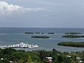
Cays and boats in La Parquera
-
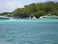
Boats in the Caribbean Sea in Lajas
-
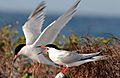
Roseate tern at La Parguera, (on the list of threatened species)
-
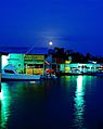
Moonrise over the dock at La Parguera


See also
 In Spanish: Lajas (Puerto Rico) para niños
