
Cabo Rojo, Puerto Rico facts for kids
Quick facts for kids
Cabo Rojo
Municipio Autónomo de Cabo Rojo
|
|||
|---|---|---|---|

Limestone cliffs near the Los Morrillos Lighthouse
|
|||
|
|||
| Nicknames:
"Cuna de Cofresí", "Los Mata con Hacha", "Ciudad Maravillosa", "Cuna de Betances", "Capital del Turismo"
|
|||
| Anthem: "Mi Cabo Rojo Querido" | |||

Map of Puerto Rico highlighting Cabo Rojo Municipality
|
|||
| Sovereign state | |||
| Commonwealth | |||
| Indigenous settlement | 30 BC – AD 120 | ||
| European settlement | early 16th century | ||
| Founded | December 16, 1771 | ||
| Founded by | Don Nicolás Ramírez de Arellano y Martínez de Matos | ||
| Barrios | |||
| Area | |||
| • Municipality | 177.40 sq mi (459.5 km2) | ||
| • Land | 70.35 sq mi (182.2 km2) | ||
| • Water | 107.05 sq mi (277.3 km2) | ||
| Population
(2020)
|
|||
| • Municipality | 47,158 | ||
| • Rank | 15th in Puerto Rico | ||
| • Density | 265.829/sq mi (102.637/km2) | ||
| • Metro | 136,212 | ||
| • CSA | 251,260 | ||
| Demonym(s) | Caborrojeños | ||
| Time zone | UTC−4 (AST) | ||
| ZIP Codes |
00623, 00622
|
||
| Area code(s) | 787/939 | ||
| Major routes | |||


Cabo Rojo (pronounced KAH-boh ROH-hoh) is a city and municipality located on the southwest coast of Puerto Rico. It is part of the larger Mayagüez metropolitan area.
Contents
History of Cabo Rojo
Early Settlements and Salt Mining
The area near Las Salinas (salt flats) has been home to people for a very long time. Archaeologists have found proof that people lived here between 30 BC and AD 120. A place called Punta Ostiones, which is now a historic site, was once a large settlement for ancient Archaic Indians.
Even with the danger of pirates and native groups, Spanish settlers arrived in the Los Morrillos area around 1511. By 1525, getting salt from the earth was a very important business in the area.
Founding of the Town
In 1759, people first asked to make Cabo Rojo an official town, but this request was not approved. Cabo Rojo was finally founded on December 17, 1771. It was started by Nicolás Ramírez de Arellano, who came from a noble Spanish family. The governor at the time, Miguel de Muesas, approved the founding. By the end of 1776, Cabo Rojo had about 1,215 people living there.
What Does "Cabo Rojo" Mean?
The name Cabo Rojo means "red cape" in English. This name comes from two things: the reddish color of its salt flats and the reddish cliffs along its southern coast. Some stories say that Christopher Columbus himself gave the area this name. The first church, built in 1783, was named San José. Today, the main Catholic church in the town square is called San Miguel Arcángel Church.
Cabo Rojo and the United States
After the Spanish–American War, Spain gave Puerto Rico to the United States in 1898. On October 18, 1898, the American flag was raised over the island. Puerto Rico became a territory of the United States.
Hurricane Maria's Impact
Hurricane Maria hit Puerto Rico on September 20, 2017. It caused a lot of damage to buildings and roads. In Cabo Rojo, about 400 homes lost their roofs. Three thousand people were left without clean drinking water. The coastal fishing village of Joyuda was one of the areas most affected in Cabo Rojo.
Geography of Cabo Rojo

Cabo Rojo is located on the southwest corner of Puerto Rico. It is part of the Western Coastal Plains. The Sierra Bermeja, which is Puerto Rico's oldest mountain range, runs through the municipality.
Cabo Rojo is bordered by Mayagüez and Hormigueros to the north. To the east, it borders San Germán and Lajas. The Caribbean Sea is to the south, and the Mona Passage is to the west. Cabo Rojo covers an area of about 72 square miles (187 square kilometers).
Even though much of Cabo Rojo's land is flat, there are some notable hills. These include Mariquita, Buena Vista, Cerro Vargas, and Peñones de Melones.
Understanding Barrios in Cabo Rojo

Like all municipalities in Puerto Rico, Cabo Rojo is divided into smaller areas called barrios. The main town buildings, central square, and large Catholic church are in a barrio known as "el pueblo" (the town).
Here are the nine barrios of Cabo Rojo:
- Bajura
- Boquerón
- Cabo Rojo barrio-pueblo
- Guanajibo
- Llanos Costa
- Llanos Tuna
- Miradero
- Monte Grande
- Pedernales
People from the El Combate community in the Boquerón barrio have a special nickname: mata con hacha. This means "those who kill with axes." It comes from an old folk tale about a fight over the salt flats. In the story, people from Cabo Rojo fought with axes against people from the nearby town of Lajas. The people from Lajas were known as tira piedras, meaning "those who throw stones."
What are Sectors?
Barrios are further divided into even smaller areas called sectores (sectors). These can have different names like urbanización (urbanization), reparto (development), or barriada (neighborhood).
Special Communities in Cabo Rojo
Puerto Rico has a program for "Special Communities" (Comunidades Especiales). These are communities that need extra support and resources. In 2014, some of the special communities in Cabo Rojo included Ballajá, Colacho, El Fuego y Las Piedras (Guaniquilla), Hoyo Bravo, Las Quebradas en Monte Grande, Pedernales, Puerto Real, and Sector Corozo.
Climate in Cabo Rojo
Cabo Rojo has a tropical climate. This means it is generally warm all year round. The average high temperature is around 90 degrees Fahrenheit (32 degrees Celsius). The average low temperature is around 70 degrees Fahrenheit (21 degrees Celsius). The area also gets a good amount of rain, especially from May to November.
Population of Cabo Rojo
In 1899, the population of Cabo Rojo was about 16,154 people. The population has grown over the years. In 2020, the total population was 47,158.
Tourism in Cabo Rojo

Cabo Rojo is a popular place for tourists. It has 127 beaches, including the famous Playa Sucia. Many hotels and marinas have been built to welcome visitors. However, environmental groups are working to make sure this growth does not harm the beautiful beaches and natural areas.
Cabo Rojo is also known for its fishing industry. The Puerto Real fishing village is especially famous. You can find many seafood restaurants there, especially in the fishing village of Joyuda.
Famous Places to Visit
- The San Miguel Arcángel Church was built between 1773 and 1783. It is located in the main town square.
- The Los Morrillos Lighthouse, known as El Faro, was built in 1881. It sits on limestone cliffs that are 200 feet above the sea. This lighthouse has some of the most amazing ocean views on Puerto Rico's west coast. It was updated in 1967 to work automatically with electricity.

- Near the lighthouse are the Salinas, or salt mines. These salt mines are said to be the oldest industry in the New World. People have been mining salt here continuously since the time of the Taínos, the native people of Puerto Rico.
- A local group, Caborrojeños Pro Salud y Ambiente, runs a visitor center near the Salinas. It is called the Centro Interpretativo Las Salinas De Cabo Rojo don Efrén Pérez Rivera. They offer free tours of the area, which has many different plants and animals.
Other interesting places include:
- Teatro Excelsior, a theater built in 1871.
- Boquerón Beach, a very popular beach.
- Cofresí Cave.
- El Combate Beach.
- Joyuda Beach.
- Joyuda Lagoon.
- Isla de Ratones, a small island.
- Buyé Beach.
- La Playuela in Los Morrillos (El Faro).
- Guaniquilla Lagoon.
- Quebrada Los Chorros.

To help local tourism during the COVID-19 pandemic in Puerto Rico, the Puerto Rico Tourism Company started a campaign called Voy Turistiendo (I'm Touring) in 2021. It included a "passport" book for each municipality. The Cabo Rojo page listed places like the Los Morrillos Lighthouse, Puente de Piedra (Stone Bridge), Centro Interpretativo Las Salinas, Hacienda Verde Tahiti (for agritourism), and several beaches.
Protected Natural Areas
- The Cabo Rojo National Wildlife Refuge is a special place for many native birds. This includes the endangered yellow-shouldered blackbird, also known as la mariquita de Puerto Rico.
- The Boquerón State Forest is one of seven state forests in Puerto Rico. It is managed by the Puerto Rico Department of Natural and Environmental Resources.
Culture of Cabo Rojo
Festivals and Events
Cabo Rojo celebrates its patron saint festival in September. This festival, called Fiestas Patronales de San Miguel Arcangel, is a religious and cultural event. It usually has parades, games, local crafts, fun rides, regional food, and live music. Famous artists like El Gran Combo de Puerto Rico have performed there.
Other festivals and events in Cabo Rojo include:
- Pescao Festival – March (celebrating fish)
- Años Cuarenta Festival – April (celebrating the 1940s)
- Chigüero Festival – April
- Betances Festival – April
- Oyster Festival – May
- Boquerón Bay Crossing – July (a swimming event)
- Watermelon Festival – July
- Retorno a la Arena – July
- La Pileta Festival – December
- Le Lo Lai Festival – December
Sports in Cabo Rojo
Cabo Rojo once had a professional basketball team called Los Turistas de Cabo Rojo. They played from 1989 to 1993.
The Indias de Mayagüez, a women's Volleyball team, played some of their games in Cabo Rojo in 2009. This was because their home stadium was being renovated.
Symbols of Cabo Rojo
The municipality of Cabo Rojo has an official flag and a coat of arms.
Flag
The flag of Cabo Rojo uses parts of the coat of arms. It does not include the sword, anchors, or crown.
Coat of Arms
The red triangle on the coat of arms stands for the "Cabo Bermejo" (Vermillion Cape) in Los Morrillos. The blue and white colors, along with the anchors, represent the sea around the coast. The flaming sword is a symbol of Archangel Saint Michael, who is the town's patron saint. The crown on top of the shield shows that Cabo Rojo is an important municipality.
Anthem
The official song of Cabo Rojo was written by Carlos Weber Asencio. It is called "Mi Cabo Rojo Querido."
Transportation in Cabo Rojo
Cabo Rojo does not have its own airport. However, it is only about 11 miles from the Eugenio María de Hostos Airport (MAZ) in Mayagüez. This airport has flights to and from San Juan. For international flights, the Rafael Hernández Airport (BQN) in Aguadilla is about 45 minutes away.
PR-100 is the main highway in Cabo Rojo. It connects north to PR-2 and south to the Boquerón area. Other important roads include PR-101, PR-102, PR-103, and PR-301. There are also 20 bridges in Cabo Rojo.
Famous People from Cabo Rojo

Many notable people have come from Cabo Rojo. Here are a few:
- Antonio Fas Alzamora has served for a very long time in the Puerto Rico Legislative Assembly.
- Ramón Emeterio Betances y Alacán (1827–1898) was a doctor and a nationalist. He is considered the "Father of the Country" because he helped start the Grito de Lares revolution.
- Salvador Brau y Asencio (1842–1912) was a journalist, poet, writer, and historian.
- Roberto Cofresí y Ramírez de Arellano (1791–1825), also known as "El Pirata Cofresí," was a famous pirate.
- Elisa Colberg (1903–1988) started the first Girl Scout troop in Puerto Rico in Cabo Rojo in 1926.
- Dra. Rebekah Colberg (1918–1985) is known as "The Mother of Women's Sports in Puerto Rico."
- Ramón López Irizarry (1897–1982) was a scientist who found an easier way to get cream from coconuts. He created the original recipe for "Coco Lopez."
- Demensio Rivera (1932–1967) was a U.S. Army veteran of the Korean War. He received the Medal of Honor, a very high military award, many years after his death.
- Efrén Pérez Rivera is a former college professor and a well-known environmental leader in Puerto Rico.
- Colonel Carlos Betances Ramírez (1910–2001) was the only Puerto Rican to lead a Battalion in the Korean War.
Images for kids
-
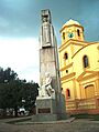
Monument to Salvador Brau in front of the San Miguel Arcángel Roman Catholic church (1783), Cabo Rojo
-
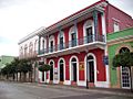
Historic buildings at Ruiz Belvis St.
-
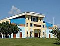
Coliseo Rebekah Colberg


See also
 In Spanish: Cabo Rojo para niños
