
Joyuda, Puerto Rico facts for kids
Quick facts for kids
Joyuda
|
||
|---|---|---|
|
Village
|
||

Evening view of the Mona Passage from Joyuda
|
||
|
||
| Nickname(s):
Milla de Oro del Buen Comer
|
||

Joyuda
Location in Puerto Rico
|
||
| Commonwealth | ||
| Municipality | ||

Joyuda is a calm fishing village on the coast of western Puerto Rico. It's found between the cities of Mayagüez and Cabo Rojo. Joyuda is famous for its delicious seafood and many restaurants. It's also a great spot for snorkeling.
Contents
Where is Joyuda Located?
Joyuda is easy to reach from Mayagüez. However, this neighborhood is part of the barrio called Miradero. Miradero is in the municipality of Cabo Rojo.
Coastal Road and Homes
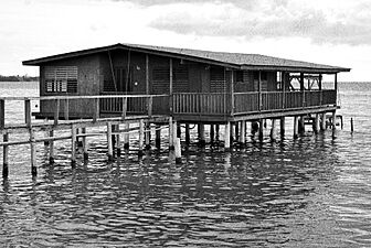
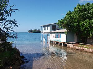
A road called P.R. 102 runs along the sea for about a mile. Along this road, you'll see many small fishing villages. There are also mini-docks and wooden homes built on stilts over the water. These homes are right next to the Joyuda Cove, which is called Ensenada Joyuda in Spanish.
Rivers and Lagoons
To the north of Joyuda is the Guanajibo River. People sometimes call it the Pirate River. This is because it seems to "steal" water from other rivers that flow south.
Even closer is the Joyuda Lagoon. This saltwater lagoon is a natural preserve. It's also a safe place for birds. The lagoon has a large mangrove forest and more than 40 types of fish. It's also bioluminescent, meaning the water glows at night!
Mice Cay: A Special Island
Just off the coast, towards the Mona Passage, is another natural preserve. Very close by is Mice Cay, or Cayo Ratones in Spanish. This small island is covered with Australian pine trees. It has sandy beaches and is a nesting spot for Brown pelicans.
A Glimpse into Joyuda's Past
Joyuda is one of the few coastal places in western Puerto Rico that doesn't claim Christopher Columbus landed there. While there's an old path nearby called "Camino el Indio" (Indian Way), not much is known about Joyuda from early colonial times.
Joyuda Appears on the Map
Joyuda really started to show up on maps in the 1800s. This was after the Spanish American wars of independence. Many people who were loyal to Spain moved to Puerto Rico, causing the population to grow.
Even foreign books from the 1800s mention Joyuda as a fishing center. It was surrounded by fields of sugarcane. The Guanajibo River helped water these fields. One Spanish book even said that Mice Cay used to be larger and closer to the coast. Pineapples and sugarcane grew on it back then. That's why it was once called Cayo Piñero, or "Cay of Pineapples."
Growing Interest and Famous Food
After the Spanish-American War, many English books about Puerto Rico were printed in New York. Joyuda was often mentioned as a landmark. Scientists, especially from the College of Agriculture (now part of the University of Puerto Rico), became interested in the Joyuda Lagoon.
A business that grew coconuts started around the lagoon. This caused a lot of the mangrove forest to be cut down. However, the fishing community itself remained quiet. What really started to get attention was their food! Homemade meals with shellfish, crab, and fish became very popular.
In the 1940s, people from nearby U.S. companies in Mayagüez started visiting. They could afford the short drive on the new road to eat "real" Puerto Rican food. By the 1950s, new neighborhoods like Guanajibo Homes were built closer to the coast and next to Joyuda.
Gallery
Places in Joyuda:
-
Home in Joyuda
-
Homes in Joyuda
-
Building in Joyuda


