
Villalba, Puerto Rico facts for kids
Quick facts for kids
Villalba
Municipio Autónomo de Villalba
|
|||
|---|---|---|---|
|
Town and Municipality
|
|||

Walter McK. Jones School in Villalba
|
|||
|
|||
| Nicknames:
"Ciudad de los Avancinos", "Ciudad del Gandul", "Ciudad de los Lagos", "Ciudad del Cooperativismo"
|
|||
| Anthem: "A las orillas del Río Jacaguas" | |||

Map of Puerto Rico highlighting Villalba Municipality
|
|||
| Commonwealth | |||
| Settled | February 1, 1852 | ||
| Founded | February 14, 1917 | ||
| Founded by | José Ramón Figueroa y Rivera, and Walter McJones | ||
| Named for | Don Juan Villalba | ||
| Barrios | |||
| Area | |||
| • Total | 37.69 sq mi (97.61 km2) | ||
| • Land | 37 sq mi (96 km2) | ||
| • Water | 0.62 sq mi (1.61 km2) | ||
| Population
(2020)
|
|||
| • Total | 22,093 | ||
| • Rank | 57th in Puerto Rico | ||
| • Density | 586.22/sq mi (226.340/km2) | ||
| Demonym(s) | Villalbeños | ||
| Time zone | UTC−4 (AST) | ||
| ZIP Code |
00766
|
||
| Area code(s) | 787/939 | ||
| Major routes | |||


Villalba (Spanish pronunciation: [biˈʎalβa]), originally known as Villa Alba, is a town and municipality in Puerto Rico. It is located in the central part of the island. You can find it northeast of Juana Díaz, south of Orocovis, and west of Coamo. Villalba is divided into several areas called barrios, including Villalba Pueblo, which is the main downtown area.
Contents
History of Villalba
Villalba was officially founded on February 14, 1917. It was established by José Ramón Figueroa y Rivera and Walter McJones. The current mayor of Villalba is Luis Javier Hernández Ortiz.
Roads and Connections
In the early days, around 1918, Villalba was not connected by highways to its nearby towns. However, by 1927, at least one highway had been built, making travel easier.
Hurricane Maria's Impact
On September 20, 2017, Hurricane Maria hit Villalba hard. The heavy rain caused many landslides, which are like small mudslides. Bridges were destroyed, and many important areas became impossible to reach. The entire electrical system was knocked out.
Many buildings were damaged, including Villalba's emergency center. The mayor shared that a big problem was the lack of oxygen for people who needed special breathing machines.
Community Spirit and Recovery
A documentary called "From Catastrophe to Hope" (De la catastrofe a la esperanza) was made in 2019. It showed how the community, volunteers, and emergency workers helped each other. Getting electricity and water back was very difficult because of Villalba's mountains. Religious leaders also offered emotional support to everyone.
After the hurricane, in 2018, the mayor talked about new ways to get electricity, like using "micro-grids." These are smaller, local power systems that can work even if the main grid is down. An architect also planned to build a new building that could generate its own power.
Geography of Villalba
Villalba is located in the central region of Puerto Rico. It sits in a valley within the Cordillera Central, which is a mountain range. The highest point in Villalba is Cerro El Bolo, which is about 3,526 feet (1,075 meters) tall.
Natural Features
Villalba is home to some beautiful natural spots:
- Guayabal Lake
- Toa Vaca Lake
- Toro Negro Forest Reserve
Villalba's Barrios

Like all towns in Puerto Rico, Villalba is divided into smaller areas called barrios. The main town area, with the municipal buildings and the big Catholic church, is called "el pueblo".
Here are the barrios in Villalba:
- Caonillas Abajo
- Caonillas Arriba
- Hato Puerco Abajo
- Hato Puerco Arriba
- Vacas
- Villalba Abajo
- Villalba Arriba
- Villalba barrio-pueblo
Sectors within Barrios
Barrios are further divided into even smaller areas called sectores (which means sectors). These sectors can have different names like urbanización or barriada.
Special Communities Program
Puerto Rico has a program for "Special Communities" (Comunidades Especiales de Puerto Rico). These are neighborhoods where people might need extra help and support from the government. In Villalba, some of these communities include the Chino neighborhood and Sector Cubones.
Energy for the Future
In 2019, the mayors of Villalba and four other towns (Orocovis, Morovis, Ciales, and Barranquitas) formed an "Energy Consortium." This is a group that works together to create strong and efficient energy systems. Their goal is to make sure their communities are prepared and have backup power in case of future storms or emergencies.
Villalba's Population
| Historical population | |||
|---|---|---|---|
| Census | Pop. | %± | |
| 1920 | 13,040 | — | |
| 1930 | 11,847 | −9.1% | |
| 1940 | 12,871 | 8.6% | |
| 1950 | 14,972 | 16.3% | |
| 1960 | 16,239 | 8.5% | |
| 1970 | 18,733 | 15.4% | |
| 1980 | 20,734 | 10.7% | |
| 1990 | 23,559 | 13.6% | |
| 2000 | 27,913 | 18.5% | |
| 2010 | 26,073 | −6.6% | |
| 2020 | 22,093 | −15.3% | |
| U.S. Decennial Census 1920-1930 1930-1950 1960-2000 2010 2020 |
|||
The population of Villalba has changed over the years. In 2020, about 22,093 people lived there. People from Villalba are called Villalbeños.
Things to See and Do
Villalba has several interesting places to visit:
- Walter McK Jones School
- Guayabal Lake
- La Corona Hill
- Toa Vaca Lake
- Toro Negro State Forest
- Biblioteca Pública (Public Library)
- Centro de Bellas Artes Adrian Rosado (Adrian Rosado Center for Fine Arts)
- Iglesia Católica Nuestra Señora del Carmen (Our Lady of Carmen Catholic Church)
Economy of Villalba
Agriculture
Farmers in Villalba grow crops like coffee and green pigeon peas.
Industry
Villalba also has factories that make different products. These include aluminum packaging, electrical and electronic machines, nutritional products, and medical devices.
Culture and Festivals
Local Celebrations
Villalba celebrates its patron saint festival, Fiestas Patronales de Nuestra Sra. del Carmen, every July. This is a fun religious and cultural event. It usually features parades, games, local crafts, amusement rides, delicious regional food, and live music.
Other exciting events in Villalba include:
- Puerto Rico Marathon - July
- Areyto Festival - November
- Carlos Báez Marathon - December
- Festival del ñame y Carne Frita (Yam and Fried Meat Festival) - November
In 2017, Villalba celebrated its 100th birthday since its founding!
Symbols of Villalba
Villalba has its own official flag and coat of arms, which represent the town.
The Flag
The flag has four horizontal stripes of different widths. From top to bottom, the colors are green, white, green, and yellow. On the left side of the top green stripe, there is a white star, just like the one on the town's shield.
The Coat of Arms
The coat of arms has a green background, which stands for the land. It shows a 19th-century village with six silver and red houses and a church. The church has the shield of the Carmelites on it. A bright white star shines over the village. Around the edge of the shield are five fig leaves. At the very top, there are three golden towers.
Transportation in Villalba


As mentioned in its history, Villalba was not connected to its neighboring towns by roads in 1918. However, by 1927, Puerto Rico Highway 149 connected Villalba to Juana Díaz and other nearby towns.
There are 23 bridges located in Villalba.
Education in Villalba
Villalba has several educational institutions:
- Villalba School District (part of the Puerto Rico Department of Education)
- Puerto Rico Criminal Justice College - Villalba Campus (which is a police academy)
Images for kids
-
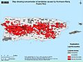
Map of landslides in Puerto Rico caused by Hurricane Maria.
-
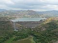
Lake Toa Vaca in Villalba


See also
 In Spanish: Villalba (Puerto Rico) para niños
