Villalba Abajo facts for kids
Quick facts for kids
Villalba Abajo
|
|
|---|---|
|
Barrio
|
|

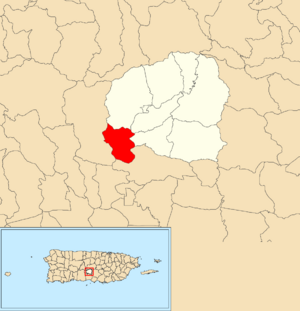
Location of Villalba Abajo within the municipality of Villalba shown in red
|
|
| Lua error in Module:Location_map at line 416: Malformed coordinates value. | |
| Commonwealth | |
| Municipality | |
| Area | |
| • Total | 2.73 sq mi (7.1 km2) |
| • Land | 2.50 sq mi (6.5 km2) |
| • Water | 0.23 sq mi (0.6 km2) |
| Elevation | 636 ft (194 m) |
| Population
(2010)
|
|
| • Total | 2,880 |
| • Density | 1,152/sq mi (445/km2) |
| Source: 2010 Census | |
| Time zone | UTC−4 (AST) |
Villalba Abajo is a special area, or barrio, located in the town of Villalba, Puerto Rico. In 2010, about 2,880 people lived there. It's a part of the beautiful island of Puerto Rico, which is a commonwealth of the United States.
A Look at Its Past
After the Spanish–American War, Spain gave Puerto Rico to the United States in 1898. This was part of the Treaty of Paris of 1898. Puerto Rico then became an unincorporated territory of the United States. This means it is a territory that belongs to the U.S. but is not fully part of it.
In 1899, the United States government counted everyone living in Puerto Rico. This count is called a census. The census found that 1,363 people lived in Villalba Abajo barrio at that time. Over the years, the population has changed:
| Historical population | |||
|---|---|---|---|
| Census | Pop. | %± | |
| 1900 | 1,363 | — | |
| 1910 | 1,454 | 6.7% | |
| 1920 | 1,833 | 26.1% | |
| 1930 | 1,407 | −23.2% | |
| 1940 | 1,453 | 3.3% | |
| 1950 | 1,757 | 20.9% | |
| 1980 | 2,940 | — | |
| 1990 | 2,998 | 2.0% | |
| 2000 | 3,054 | 1.9% | |
| 2010 | 2,880 | −5.7% | |
| U.S. Decennial Census 1899 (shown as 1900) 1910-1930 1930-1950 1980-2000 2010 |
|||
What Are Sectors?
In Puerto Rico, barrios are like small local areas. These barrios are then divided even further into smaller parts called sectores (which means sectors in English).
The names of these sectores can be different. Some are simply called sector, while others might be named urbanización, reparto, barriada, or residencial. Each name describes a different type of community or housing area.
Here are some of the sectores you can find in Villalba Abajo barrio:
- Barriada Borinquen
- Carretera 149 Intersección 514
- Carretera 149
- Corillo
- Egida Villalba Housing for the Elderly
- El Semil Abajo
- Hacienda Juanita
- Hogar Las Margaritas Dos
- Residencial Efraín Suárez
- Residencial Enudio Negrón
- Residencial Maximino Miranda
- Sector Hacienda Sosa
- Sector Jagueyes Abajo (includes Parcelas Cotorreras, Los Olivieri, La Escuela, Carretera 149)
- Sector Jagueyes Arriba (includes Lado Bravo, Los Cabros, Roque, Carretera 149 Intersección 513)
- Sector Romero (includes Las Cumbres, Las Talas Largas, Santo Domingo, El Polvorín, El Trueno, Romero Interior, La Escuela, Los Olivari)
- Sector Tierra Santa (includes El Achiote, El Cercao, El Cementerio, El Mamey, Calle Vieja, El Complejo, Los Trotadores)
- Urbanización Estancias de Valle Hermoso
- Urbanización Las Alondras
- Urbanización Nabori
- Urbanización Quintas del Alba
- Urbanización Sagrado Corazón
- Urbanización Tierra Santa
- Urbanización Valle Escondido
- Urbanización Valle Hermoso
- Urbanización Villa Laura
- Urbanización Vista Bella
- Villalba Apartments
See also
 In Spanish: Villalba Abajo para niños
- List of communities in Puerto Rico
- List of barrios and sectors of Villalba, Puerto Rico
 | Stephanie Wilson |
 | Charles Bolden |
 | Ronald McNair |
 | Frederick D. Gregory |

