Caonillas Arriba, Villalba, Puerto Rico facts for kids
Quick facts for kids
Caonillas Arriba
|
|
|---|---|
|
Barrio
|
|

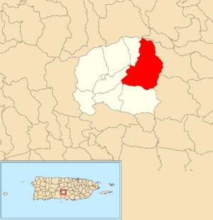
Location of Caonillas Arriba within the municipality of Villalba shown in red
|
|
| Commonwealth | |
| Municipality | |
| Area | |
| • Total | 8.11 sq mi (21.0 km2) |
| • Land | 8.08 sq mi (20.9 km2) |
| • Water | 0.03 sq mi (0.08 km2) |
| Elevation | 1,424 ft (434 m) |
| Population
(2010)
|
|
| • Total | 1,537 |
| • Density | 190.2/sq mi (73.4/km2) |
| Source: 2010 Census | |
| Time zone | UTC−4 (AST) |
Caonillas Arriba is a special area called a barrio in the town of Villalba, Puerto Rico. It's located in the beautiful mountains of Puerto Rico. In 2010, about 1,537 people lived there.
Contents
A Look Back: History of Caonillas Arriba
Puerto Rico became part of the United States after the Spanish–American War. This happened because of a special agreement called the Treaty of Paris of 1898. In 1899, the United States government counted everyone living in Puerto Rico. They found that Caonillas Arriba had about 2,200 people at that time.
The number of people living in Caonillas Arriba has changed over the years. Here's how the population has grown and shrunk:
| Historical population | |||
|---|---|---|---|
| Census | Pop. | %± | |
| 1900 | 2,200 | — | |
| 1910 | 1,627 | −26.0% | |
| 1920 | 1,883 | 15.7% | |
| 1930 | 1,588 | −15.7% | |
| 1940 | 1,605 | 1.1% | |
| 1950 | 1,718 | 7.0% | |
| 1980 | 1,473 | — | |
| 1990 | 1,333 | −9.5% | |
| 2000 | 1,811 | 35.9% | |
| 2010 | 1,537 | −15.1% | |
| U.S. Decennial Census 1899 (shown as 1900) 1910-1930 1930-1950 1980-2000 2010 |
|||
What are Sectors?
Barrios like Caonillas Arriba are often divided into smaller areas. These smaller areas are called sectores (say: sek-TOR-es). You can think of them like neighborhoods within a bigger area.
There are different kinds of sectores. Some are just called "sector," while others might be called "urbanización" (a planned neighborhood) or "reparto" (a land division).
Neighborhoods in Caonillas Arriba
Caonillas Arriba has several important sectors. These include:
- Carretera 151 Intersección 553
- La Gallera (also known as Sector San Miguel)
- Sector Caonillas, which has smaller areas like La Sierrita, La Escuela, Los Aponte, Cubones Norte, El Puente, Caonillas (Ceo Rivera), Finca El Coroco, La Terraza, and El Empalme
- Sector Dajaos, which includes La Toyosa, Los Cruz, and Carretera 151 Intersección 559
- Sector El Limón, which has El Palmar, La Hacienda, La Cuesta Limón, Los Santiago, La Escuela, El Hoyito, Los Vázquez, Los Rivera, and El Camino Valillo Carretera 151
- Sector La Ortiga (also known as El Pueblito)
Improving Water Service in La Sierrita
One of the areas in Caonillas Arriba is La Sierrita. For many years, the people living there did not have regular water service. This meant it was hard to get clean water for daily needs.
In 2020, a group called the Federal Emergency Management Agency (FEMA) set aside money. This money is for making big improvements to the water systems in La Sierrita and other nearby places. This will help make sure residents have reliable water service.
See also
 In Spanish: Caonillas Arriba (Villalba) para niños
- List of communities in Puerto Rico
- List of barrios and sectors of Villalba, Puerto Rico
 | Percy Lavon Julian |
 | Katherine Johnson |
 | George Washington Carver |
 | Annie Easley |


