
Orocovis, Puerto Rico facts for kids
Quick facts for kids
Orocovis
Municipio de Orocovis
|
|||
|---|---|---|---|
|
Town and Municipality
|
|||

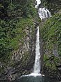
Salto de Doña Juana waterfall in Orocovis
|
|||
|
|||
| Nicknames:
"Corazón de Puerto Rico", "El Centro Geográfico de Puerto Rico"
|
|||
| Anthem: "Mi patria es una bella isla" | |||

Map of Puerto Rico highlighting Orocovis Municipality
|
|||
| Commonwealth | |||
| Founded | November 10, 1825 | ||
| Founder | Juan Rivera de Santiago | ||
| Named for | Orocobix | ||
| Barrios | |||
| Area | |||
| • Total | 71.1 sq mi (184.17 km2) | ||
| • Land | 71.0 sq mi (184 km2) | ||
| • Water | 0.1 sq mi (0.17 km2) | ||
| Population
(2020)
|
|||
| • Total | 21,434 | ||
| • Rank | 58th in Puerto Rico | ||
| • Density | 301.46/sq mi (116.382/km2) | ||
| Demonym(s) | Orocoveños | ||
| Time zone | UTC-4 (AST) | ||
| ZIP Code |
00720
|
||
| Area code(s) | 787/939 | ||
| Major routes | |||


Orocovis is a town and municipality in the center of Puerto Rico. Its name comes from the Taíno chief Orocobix. Juan Rivera de Santiago founded the town in 1825. Orocovis has 17 areas called barrios. It is part of the larger San Juan metropolitan area. The town is surrounded by other municipalities like Villalba, Coamo, Morovis, Corozal, Ciales, Jayuya, and Barranquitas.
Contents
History of Orocovis
Long before the Spanish arrived in the 1500s, the Taíno lived in this area. Their leader was cacique Orocobix, and his tribe was called the Jatibonicu. When the Spanish settled, this region was part of larger areas like Manatí and Coamo. By 1823, Orocovis was a part of Barranquitas. Another area called Barros was part of Morovis. Eventually, Orocovis and Barros joined to form a new town.
In 1825, Juan Rivera de Santiago worked with local people to ask the Governor for permission to start a new municipality. They bought land in the Barros area. However, because it was far from water, the town was moved to its current location. On November 10, 1825, Governor Miguel de la Torre allowed the new municipality of Barros to be founded.
In 1838, a church called San Juan Bautista de Barros was built. Sadly, a fire in 1875 destroyed the church and many other buildings.
Orocovis is known as the "Heart of Puerto Rico" (Corazón de Puerto Rico) and the "Geographical Center of Puerto Rico" (Centro Geográfico de Puerto Rico). This is because it's located right in the middle of the island. Some locals believe the exact center is in the Pellejas barrio.
After the Spanish–American War in 1898, Spain gave Puerto Rico to the United States. In 1899, a census showed that Barros, as Orocovis was then called, had 14,845 people. In 1928, the name was officially changed to Orocovis to honor the Taíno chief.
Geography and Natural Features
Orocovis is a very mountainous municipality with many valleys. Most of its land is part of the Cordillera Central, a mountain range that runs through the island. The highest peaks are in the southern part of the municipality. The highest point in Orocovis is Cerro Mogote.
Several rivers flow through Orocovis, including the Toro Negro, Sana Muertos, Orocovis, Matrullas, and Bauta rivers. There are also creeks like Doña Juana, Palmar, and Cacaos. Orocovis has two lakes: El Guineo and Matrullas Lake. El Guineo is the highest lake in all of Puerto Rico.
Barrios of Orocovis

Like all municipalities in Puerto Rico, Orocovis is divided into smaller areas called barrios. The main town area, with the municipal buildings and the big Catholic church, is called "el pueblo".
Special Communities in Orocovis
Some communities in Puerto Rico are called "Special Communities" (Comunidades Especiales). These are areas that need extra help and support. In Orocovis, some of these communities include Ala de la Piedra, Alturas de Orocovis, Cacao, Sector Parcelas in Botijas 1, Botijas II, Comunidad Miraflores, and La Pica (Luis M. Alfaro).
Energy for the Future
In 2019, Orocovis joined with Villalba, Morovis, Ciales, and Barranquitas to form an Energy Consortium. This group works together to make sure their towns have strong and reliable energy systems. They also plan for backup power in case of outages. This was the first group of its kind in Puerto Rico.
Culture and Arts
The Musical Capital of Puerto Rico
Orocovis is often called "The Musical Capital of Puerto Rico." Many famous Puerto Rican musicians were born or grew up here. These include bandleader Bobby Valentín, folk singer Andrés Jiménez, merengue singer Manny Manuel, and salsa legend William "H. Christ" Corchado. The talented Colón-Zayas family, including singer Emma and cuatro player Edwin, also comes from Orocovis.
Santos (Art Figurines)

Santeros are folk artists who create beautiful wooden religious statues called Santos. For a while, this art form was fading away. But Celestino Avilés Meléndez (1925-2004), a santero from Orocovis, helped save it. In 1983, he started a meeting for santeros, which still happens every December in Orocovis. He also opened the Museo Orocoveño Familia Avilés Inc. in 1982. Thanks to his efforts, by 2019, there were over 300 santeros making santos in Puerto Rico.
Tourism and Fun Things to Do

Orocovis offers many beautiful places to visit and enjoy nature.
- Bosque Estatal de Toro Negro (Toro Negro State Forest)
- Las Piscinas del Area Recreativa Doña Juana (Doña Juana Pool and Recreational Park)
- Las Cabañas de Doña Juana (a popular restaurant)
- Área Recreativa de Damián (Damian Recreational Park)
- Many scenic rivers and panoramic views.
Landmarks and Places of Interest

- Indian Cave
- Matrullas Lake
- El Guineo Lake
- Orocovis Museum
- Taíno Refuge
- Mirador Villalba - Orocovis (a lookout point)
- Toro Negro State Forest
- Área Recreativa Cerro La Guaira (Recreational Park)
- Cascada Chorro de Doña Juana (Doña Juana Waterfall)
Festivals and Events
Orocovis loves to celebrate! The town holds its main festival, the Fiestas Patronales de San Juan Bautista, in June. This religious and cultural event includes parades, games, local crafts, rides, delicious food, and live music.
Other fun festivals and events in Orocovis include:
- Children's Theater Festival – April
- Shrimp Festival – July
- Artisan Fair – September
- Youth Festival – October
- Puerto Rican National Meat Pie Festival – November
Economy and Jobs
Agriculture
Farmers in Orocovis raise cattle and grow coffee, fruits, tobacco, and wheat. A new business growing hydroponic lettuce was even talking about supplying Walmart in 2019!
Industrial
Orocovis also has several small factories that make nutritional products.
Population and People
| Historical population | |||
|---|---|---|---|
| Census | Pop. | %± | |
| 1900 | 14,845 | — | |
| 1910 | 15,028 | 1.2% | |
| 1920 | 15,758 | 4.9% | |
| 1930 | 16,115 | 2.3% | |
| 1940 | 19,770 | 22.7% | |
| 1950 | 21,181 | 7.1% | |
| 1960 | 20,362 | −3.9% | |
| 1970 | 20,201 | −0.8% | |
| 1980 | 19,332 | −4.3% | |
| 1990 | 21,158 | 9.4% | |
| 2000 | 23,844 | 12.7% | |
| 2010 | 23,423 | −1.8% | |
| 2020 | 21,434 | −8.5% | |
| U.S. Decennial Census 1899 (shown as 1900) 1910-1930 1930-1950 1960-2000 2010 2020 |
|||
In 2000, Orocovis had a population of 23,844 people. This means there were about 378 people living in every square mile. After a small drop in the 1980s, the population has been growing steadily.
Most people in Orocovis have Spanish or White heritage (81.4%). About 4.1% are Black, and 0.4% are Native American.
| Race - Orocovis, Puerto Rico - 2000 Census | ||
|---|---|---|
| Race | Population | % of Total |
| White | 19,401 | 81.4% |
| Black/African American | 975 | 4.1% |
| American Indian and Alaska Native | 87 | 0.4% |
| Asian | 15 | 0.1% |
| Native Hawaiian/Pacific Islander | 5 | 0.0% |
| Some other race | 2,618 | 11.0% |
| Two or more races | 743 | 3.1% |
Education for Students
Orocovis has many public and private schools. The Puerto Rico Department of Education manages the public school system.
Transportation and Roads
There isn't a major highway that goes directly to Orocovis. You can reach the town using roads like #137 and #155 from the north. From the south, you can use roads #138 and #155. Orocovis is about an hour and a half drive from San Juan, the capital of Puerto Rico. The municipality has 17 bridges.
Symbols of Orocovis
The municipality of Orocovis has its own official flag and coat of arms.
Flag of Orocovis
The flag of Orocovis has five vertical stripes. The two green stripes on the sides represent the nearby areas of Aibonito and Barranquitas. The blue stripe in the middle stands for the land ruled by the Taíno chief Orocobix long ago. Two thin white stripes separate these colors. They represent the land given by Barranquitas and Morovis to create the municipality in 1825.
In the center of the blue stripe, there is an oval with a sun. This sun has seventeen rays, showing the seventeen different barrios of the town. The sun is the center of our solar system, and in the flag, it symbolizes Orocovis as the center of the island of Puerto Rico.
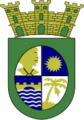
Coat of Arms
The oval shape on the coat of arms looks like the letter "O," which is the first letter of Orocovis. Inside the oval, there are four sections, each with a symbol of the town. In the top left, there's a gold image of a Taíno Indian on a silver background. This represents the great Chief Orocobix and the town's Indian heritage. The Indian faces a golden star or sun in the top right section, on a blue background. This sun has seventeen rays, representing the town's seventeen barrios.
In the bottom right section, there's a golden plantain plant on a silver background. This shows the importance of agriculture in Orocovis. Finally, in the bottom left section, there's a golden bridge over a river on a blue background.
Images for kids
-
Salto de Doña Juana waterfall in Orocovis
-

Flag of Orocovis
-
Coat of arms of Orocovis
-

Map of Puerto Rico highlighting Orocovis Municipality
See also
 In Spanish: Orocovis para niños
