
Botijas facts for kids
Quick facts for kids
Botijas
|
|
|---|---|
|
Barrio
|
|
.jpg)
Puerto Rico Highway 568 between Botijas and Mata de Cañas barrios
|
|

Location of Botijas within the municipality of Orocovis shown in red
|
|

Botijas
Location in Caribbean
|
|
| Commonwealth | |
| Municipality | |
| Area | |
| • Total | 4.94 sq mi (12.8 km2) |
| • Land | 4.94 sq mi (12.8 km2) |
| • Water | 0 sq mi (0 km2) |
| Elevation | 2,028 ft (618 m) |
| Population
(2010)
|
|
| • Total | 3,720 |
| • Density | 753/sq mi (291/km2) |
| Source: 2010 Census | |
| Time zone | UTC−4 (AST) |
Botijas is a barrio (which is like a neighborhood or district) in the town of Orocovis, Puerto Rico. In 2010, about 3,720 people lived there. It is located in the central part of Puerto Rico.
What is Botijas?
Botijas is one of the many barrios that make up the municipality of Orocovis. Think of a municipality as a city or town, and its barrios are like its different sections or neighborhoods. Botijas is a rural area, meaning it has more open spaces and less crowded areas compared to big cities.
How Botijas is Divided
Barrios are often divided into even smaller areas. These smaller areas are called sectores (sectors). Sectores can be different types of places. Some are just called sector, while others might be urbanización (a planned housing area) or barriada (a smaller neighborhood).
Botijas has many sectores. Some of these include Sector Las Parcelas, Sector La Loma, and Sector El Puente. These smaller divisions help people find their way around and organize communities.
History of Botijas
Puerto Rico has a long and interesting history. After the Spanish–American War in 1898, Spain gave Puerto Rico to the United States. This made Puerto Rico an unincorporated territory of the U.S.
Soon after, in 1899, the United States government took a count of all the people in Puerto Rico. This count is called a census. The census found that 891 people lived in Botijas barrio at that time.
Over the years, the number of people living in Botijas has changed. Here's how the population has grown and changed:
| Historical population | |||
|---|---|---|---|
| Census | Pop. | %± | |
| 1900 | 891 | — | |
| 1980 | 3,394 | — | |
| 1990 | 3,168 | −6.7% | |
| 2000 | 3,794 | 19.8% | |
| 2010 | 3,720 | −2.0% | |
| U.S. Decennial Census 1899 (shown as 1900) 1910-1930 1930-1950 1980-2000 2010 |
|||
Images for kids
-
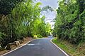
Puerto Rico Highway 568 between Botijas and Mata de Cañas barrios
-
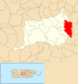
Location of Botijas within the municipality of Orocovis shown in red
See also
 In Spanish: Botijas (Orocovis) para niños
- List of communities in Puerto Rico
