Bermejales facts for kids
Quick facts for kids
Bermejales
|
|
|---|---|
|
Barrio
|
|

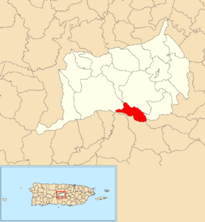
Location of Bermejales within the municipality of Orocovis shown in red
|
|
| Commonwealth | |
| Municipality | |
| Area | |
| • Total | 1.87 sq mi (4.8 km2) |
| • Land | 1.87 sq mi (4.8 km2) |
| • Water | 0 sq mi (0 km2) |
| Elevation | 2,595 ft (791 m) |
| Population
(2010)
|
|
| • Total | 500 |
| • Density | 267.4/sq mi (103.2/km2) |
| Source: 2010 Census | |
| Time zone | UTC−4 (AST) |
Bermejales is a special kind of area called a barrio in the town of Orocovis, Puerto Rico. Think of it like a neighborhood or a district. In 2010, about 500 people lived there.
What are Barrios and Sectors?
In Puerto Rico, a "barrio" is like a division of a town or municipality. These barrios are then split into even smaller areas called sectores (which means "sectors" in English). These sectors can have different names, like urbanización (a planned housing area) or barriada (a neighborhood).
Here are some of the sectors you can find in Bermejales barrio:
- Sector Buena Vista
- Sector El Collao
- Sector El Cometa
- Sector La Cuchilla
- Sector El Aguacate
- Sector El Mirador
- Sector Tino Torres
A Look Back in Time
Puerto Rico became a territory of the United States after the Spanish–American War. This happened because of an agreement called the Treaty of Paris of 1898.
In 1899, the United States government counted everyone living in Puerto Rico. They found that 1,317 people lived in Bermejales barrio at that time. Over the years, the population has changed:
| Historical population | |||
|---|---|---|---|
| Census | Pop. | %± | |
| 1900 | 1,317 | — | |
| 1970 | 669 | — | |
| 1980 | 669 | 0.0% | |
| 1990 | 646 | −3.4% | |
| 2000 | 570 | −11.8% | |
| 2010 | 500 | −12.3% | |
| U.S. Decennial Census 1899 (shown as 1900) 1910-1930 1930-1950 1980-2000 2010 |
|||
See also
 In Spanish: Bermejales (Orocovis) para niños
- List of communities in Puerto Rico
 | Valerie Thomas |
 | Frederick McKinley Jones |
 | George Edward Alcorn Jr. |
 | Thomas Mensah |


