
Comerío, Puerto Rico facts for kids
Quick facts for kids
Comerío
Municipio Autónomo de Comerío
|
|||
|---|---|---|---|
|
Town and Municipality
|
|||

View of Comerío from Lazos Hill
|
|||
|
|||
| Nicknames:
"La Perla de Plata", "Pueblo de los Guabaleros"
|
|||
| Anthem: "Con alma henchida de amor y ensueño" | |||

Map of Puerto Rico highlighting Comerío Municipality
|
|||
| Sovereign state | |||
| Commonwealth | |||
| Settled | late 18th century | ||
| Founded | June 12, 1826 | ||
| Founded by | Don José Díaz | ||
| Barrios | |||
| Area | |||
| • Total | 28.24 sq mi (73.13 km2) | ||
| • Land | 28 sq mi (73 km2) | ||
| • Water | 0.05 sq mi (.13 km2) | ||
| Population
(2020)
|
|||
| • Total | 18,883 | ||
| • Rank | 61st in Puerto Rico | ||
| • Density | 668.76/sq mi (258.211/km2) | ||
| Demonym(s) | Comerieños | ||
| Time zone | UTC−4 (AST) | ||
| ZIP Code |
00782
|
||
| Area code(s) | 787/939 | ||
| Major routes | |||


Comerío is a town and municipality in Puerto Rico. It is located in the center-eastern part of the island. The town is north of Aibonito and south of Naranjito and Bayamón. It is also east of Barranquitas and west of Cidra and Aguas Buenas. Comerío is part of the larger San Juan-Caguas-Guaynabo Metropolitan Statistical Area.
Contents
History of Comerío

Comerío was officially founded on June 12, 1826. Its first name was Sabana del Palmar. Later, it was changed to Comerío.
In 1854, about 1,000 acres of land were used for farming. By 1894, Comerío had one sugar plantation and two coffee plantations. In the early 1900s, people from Comerío had a short, famous "territory war" with people from Barranquitas.
Puerto Rico became a territory of the United States after the Spanish–American War in 1898. In 1899, a census showed that 8,249 people lived in Comerío.
Hurricane Maria's Impact
On September 20, 2017, Hurricane Maria caused many landslides in Comerío. The river flooded the center of the town. A week later, the hospital ran out of fuel for its generator. Landslides made it almost impossible to get supplies in or out.
Over 4,000 homes were damaged, and 1,537 were completely destroyed. The Ohio National Guard helped restore water systems. Two months after the hurricane, the mayor said no one had arrived to restore electricity. Doctors from New York also volunteered to help the town.
Geography of Comerío
The main rivers in Comerío are Río de la Plata and Río Hondo.
Barrios of Comerío

Like all municipalities in Puerto Rico, Comerío is divided into smaller areas called barrios. The town center, with its main buildings and church, is in a barrio called "el pueblo."
Sectors within Barrios
Barrios are further divided into even smaller areas called sectores (sectors). These can be different types, like urbanización (housing developments) or barriada (neighborhoods).
Special Communities
Some communities in Puerto Rico are called Comunidades Especiales (Special Communities). These are areas where people might need extra help and support. In 2014, some of these special communities in Comerío included Barriada Cielito, Sector Villa Brava, El 26, El Higüero, El Verde, La Juncia, La Pietra Cedrito, Río Hondo, and Vuelta del Dos.
Tourism in Comerío
The Puerto Rico Tourism Company has a program called Voy Turistiendo ("I'm Touring"). It helps people explore local places. Comerío has several interesting spots for visitors.
Landmarks and Places to Visit
Some famous places in Comerío include:
- La Tiza Peak
- La Mora Caves
- La Plata River
- Las Bocas Canyon
- Las Pailas
- Los Pilones
- Media Luna Recreation Park
- Tobacco Warehouse
- The main town square
- El Salto Hydroelectric Dams 1 and 2
Economy of Comerío
Agriculture
Comerío was once known as "El Pueblo del Tabaco" (Tobacco Town). Tobacco farming was a very important part of its economy for many years.
Culture in Comerío
Festivals and Events
Comerío celebrates its patron saint festival in August. This event is called Fiestas Patronales Santo Cristo de la Salud. It is a religious and cultural celebration with parades, games, local crafts, rides, food, and live music.
Other fun festivals and events in Comerío include:
- Spring Carnival – April
- La Mora Cave Festival – June 1, 2, 3
- Jíbaro Festival – June
- El Jobo Festival – July
- San Andrés Apóstol Festivities – November
- El Seco Marathon – December
- Christmas Fantasy – December
Religion
The first Methodist Church in Comerío was established in 1904.
Population of Comerío
| Historical population | |||
|---|---|---|---|
| Census | Pop. | %± | |
| 1900 | 8,249 | — | |
| 1910 | 11,170 | 35.4% | |
| 1920 | 14,708 | 31.7% | |
| 1930 | 16,715 | 13.6% | |
| 1940 | 18,539 | 10.9% | |
| 1950 | 17,966 | −3.1% | |
| 1960 | 18,583 | 3.4% | |
| 1970 | 18,819 | 1.3% | |
| 1980 | 18,212 | −3.2% | |
| 1990 | 20,265 | 11.3% | |
| 2000 | 20,002 | −1.3% | |
| 2010 | 20,778 | 3.9% | |
| 2020 | 18,883 | −9.1% | |
| U.S. Decennial Census 1899 (shown as 1900) 1910–1930 1930–1950 1960–2000 2010 2020 |
|||
Symbols of Comerío
The municipality of Comerío has its own official flag and coat of arms.
Flag of Comerío
The flag is divided into four sections, with green and white colors. In the top right section, there is a yellow cross with an anchor.
Coat of Arms of Comerío
The coat of arms has four parts and a shield in the middle.
- The top left part has a green background with a golden cross. This represents the Holy Christ the Healer, who is the town's patron saint.
- The bottom left part has green stripes on a silver background. This symbolizes the Comerío waterfalls and the La Plata River.
- The top right part shows three royal palms. These remind us of the town's original name, Sabana del Palmar.
- An wavy line represents the mist that often covers the town.
- A crown with Taino designs sits at the top. This represents the cacique (chief) of the Taino people.
- A tobacco plant is also shown, reminding us of the town's history with tobacco farming.
- The words "the pearl of La Plata" are written, referring to Comerío's location by the La Plata River.
- A castle with turrets (small towers) is a symbol used by municipalities in Puerto Rico.
Transportation in Comerío
You can travel to Comerío by public bus from Bayamón. This is the main way to get there using public transport. There are also 16 bridges in Comerío.
Famous People from Comerío
- Manuel A. Pérez (1890–1951) – A well-known professor.
- Enrique Pérez Santiago – A doctor who specializes in blood (hematologist).
- Lalah (born 2001) – A singer and songwriter.
Images for kids
-
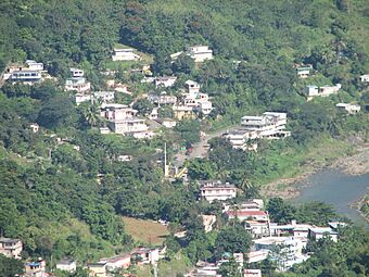
View looking north from Vega Redonda barrio in Comerio
-
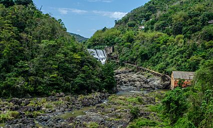
Old dam at El Salto, one of the oldest in Puerto Rico.

.jpeg)
See also
 In Spanish: Comerío para niños
