Comerío barrio-pueblo facts for kids
Quick facts for kids
Comerío barrio-pueblo
Pueblo de Comerío
|
|
|---|---|
|
Municipality Seat
|
|

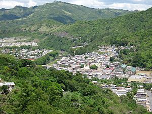
View of Comerío Pueblo from Lazos Hill
|
|

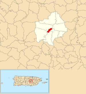
Location of Comerío barrio-pueblo within the municipality of Comerío shown in red
|
|
| Commonwealth | |
| Municipality | |
| Area | |
| • Total | 0.40 sq mi (1.0 km2) |
| • Land | 0.39 sq mi (1.0 km2) |
| • Water | 0.01 sq mi (0.03 km2) |
| Elevation | 623 ft (190 m) |
| Population
(2010)
|
|
| • Total | 3,657 |
| • Density | 9,376.9/sq mi (3,620.4/km2) |
| Source: 2010 Census | |
| Time zone | UTC−4 (AST) |
Comerío barrio-pueblo is a special part of Comerío, a town in Puerto Rico. It's like the main downtown area. This is where the local government offices are located. In 2010, about 3,657 people lived here.
Contents
What is a Barrio-Pueblo?
In Puerto Rico, a barrio is like a neighborhood or district. The barrio-pueblo is unique because it's the central part of a municipality. Think of it as the heart of the town!
These barrios are often divided into smaller areas called sectores. These sectors can have different names, like urbanización (a planned neighborhood) or barriada (a smaller community).
A Look at Comerío's History
Long ago, following traditions from Spain, every town in Puerto Rico had a pueblo barrio. This central area always included a main square, the town hall, and a Catholic church.
Fun festivals called Fiestas patronales are still held in the central square every year. These celebrations honor the town's patron saint.
Puerto Rico became a territory of the United States after the Spanish–American War in 1898. This happened under the Treaty of Paris of 1898. In 1899, a count of the people living in Comerío Pueblo showed there were 1,191 residents. Over the years, the population has changed, growing and shrinking at different times.
The Heart of the Town: The Central Plaza
The central plaza, or town square, is a very important place in Comerío. It's where people gather for fun events and to socialize. You can find people there from morning until night!
Spanish laws from the early 1800s, called the Laws of the Indies, explained how these plazas should be designed. They said the plaza should be big enough for all the town's celebrations. The laws also suggested that nearby streets should have covered walkways. These walkways would protect people from the sun and rain.
The Church in the Plaza
Right across from the central plaza is a Catholic church called the Parroquia Santo Cristo de la Salud. Churches have been in this spot since 1829. The building you see today was opened in the 1970s.
See also
 In Spanish: Comerío (Comerío) para niños
- List of communities in Puerto Rico
 | Misty Copeland |
 | Raven Wilkinson |
 | Debra Austin |
 | Aesha Ash |


