
Maricao, Puerto Rico facts for kids
Quick facts for kids
Maricao
Municipio Autónomo de Maricao
|
|||
|---|---|---|---|
|
Town and Municipality
|
|||
.jpg)
Maricao High School
|
|||
|
|||
| Nicknames:
"Pueblo de las Indieras", "Ciudad del Monte del Estado", "Ciudad de Leyenda y Romance", "Tierra del Café"
|
|||
| Anthem: "Sobre las verdes altura" | |||

Map of Puerto Rico highlighting Maricao Municipality
|
|||
| Sovereign state | |||
| Commonwealth | |||
| Settled | 1848 | ||
| Founded | April 10, 1874 | ||
| Barrios | |||
| Area | |||
| • Total | 37.1 sq mi (96.0 km2) | ||
| • Land | 37.1 sq mi (96 km2) | ||
| • Water | 0 sq mi (0 km2) | ||
| Population
(2020)
|
|||
| • Total | 4,455 | ||
| • Rank | 77th in Puerto Rico | ||
| • Density | 120.08/sq mi (46.406/km2) | ||
| Demonym(s) | Maricaeños | ||
| Time zone | UTC−4 (AST) | ||
| ZIP Code |
00606
|
||
| Area code(s) | 787/939 | ||
| Major routes | |||


Maricao is a small town and municipality in Puerto Rico. It is located on the western side of the Cordillera Central, which is a mountain range. Maricao is one of the least populated municipalities in Puerto Rico.
The town is built around a small square in a hilly area. It is north of San Germán, Sabana Grande, and Yauco. To its south are Las Marías and Lares. It is southeast of Mayagüez and west of Adjuntas. Maricao is divided into six main areas called barrios, plus the downtown area known as Maricao Pueblo.
Maricao is next to the Maricao Fish Hatchery. This hatchery has tanks and pools where about 25,000 fish are raised each year. These fish are used to stock local farm ponds and lakes. The hatchery is part of the Maricao State Forest, also called Monte del Estado. This forest is home to many bird species. It has a stone observation tower that offers amazing views all the way to the coast and the Mona Passage.
In 2020, Maricao had a population of 4,455 people.
Contents
History of Maricao

Maricao was officially founded on April 1, 1874. A group of people, including Bernardo Collado and Julián Ayala, asked for permission to create a new town. They explained that the roads to San Germán, where Maricao originally belonged, were too long and hard to travel. They also mentioned that a church had already been built there in 1866.
During the 1800s, Maricao's economy grew a lot because of the coffee boom. Coffee was a very important crop. However, by the early 1900s, the coffee boom ended, and the town's economy faced challenges. Many old coffee plantation houses have been turned into museums to attract tourists. While Puerto Rico still grows some special coffee, large-scale coffee farming is not as common as it used to be.
After the Spanish–American War, Puerto Rico became a territory of the United States in 1898. In 1899, a census showed that Maricao had a population of 8,312 people.
On September 20, 2017, Hurricane Maria hit Puerto Rico. This powerful storm caused many landslides that blocked roads into Maricao. Rivers overflowed, washing away highways and bridges. Many residents were cut off from communication. Some areas of Maricao had more than 25 landslides per square mile, which greatly affected older residents.
Geography and Natural Features
Maricao is a very mountainous area with rugged terrain. It is located in the western part of Puerto Rico's main mountain range, the Cordillera Central.
Maricao's Barrios

Like all municipalities in Puerto Rico, Maricao is divided into smaller areas called barrios. The main town area, where the municipal buildings, central square, and a large Catholic church are located, is known as "el pueblo".
Special Communities in Maricao
Some communities in Puerto Rico are called Comunidades Especiales de Puerto Rico, or "Special Communities." These are areas where citizens might face challenges like social exclusion. In 2014, some of these special communities in Maricao included Llanadas, El 30 (Sector Los Mercados) in Indiera Alta, La Cuchilla, Los Cuadros-Montoso, and Villa Esperanza.
Culture and Tourism
.jpg)
Maricao was once very important for coffee production. Because of this history, some old coffee haciendas (plantations) have been turned into museums or places for visitors to stay. Examples include Hacienda Delicias and Hacienda Juanita, though Hacienda Juanita is now closed.
Other fun places for tourists to visit are the Bambúa Recreational Center and the Maricao Fish Nursery. If you love nature, you can explore the Monte del Estado forest reserve, the Maricao River Natural Protected Area, Prieto Lake, and the Salto de Curet waterfall.
Festivals and Events

Maricao celebrates its main festival, called Fiestas Patronales de San Juan Bautista, in June. This is a religious and cultural celebration. It usually includes parades, games, local crafts, amusement rides, traditional food, and live music.
Another important event is the End of the Coffee Harvest Festival, known locally as the Festival del Acabe de Café. It takes place on President's Day weekend in February. This festival celebrates an old tradition where plantation owners would host a big feast for their workers after the coffee harvest was finished. The festival started in 1977.
Other festivals and events in Maricao include:
- Indigenous Day Festival - April (celebrated in the Indiera barrios)
- Homage to Mothers – May
- Youth Festival – July
- New Year's Eve celebrations – December
Economy of Maricao
.jpg)
For many years, Maricao's economy has depended on agriculture, especially growing coffee. Farmers also grow fruits and vegetables in the town. Currently, there is one factory in Maricao called Fenwal Blood Technologies. This factory makes devices and materials used for blood donation, transfusions, and storing blood. Tourism also plays a role in the town's economy.
For the past twenty years, Maricao has had the highest number of children living in poverty in Puerto Rico.
Population and Demographics
| Historical population | |||
|---|---|---|---|
| Census | Pop. | %± | |
| 1900 | 8,312 | — | |
| 1910 | 7,158 | −13.9% | |
| 1920 | 8,291 | 15.8% | |
| 1930 | 6,463 | −22.0% | |
| 1940 | 7,724 | 19.5% | |
| 1950 | 7,403 | −4.2% | |
| 1960 | 6,990 | −5.6% | |
| 1970 | 5,991 | −14.3% | |
| 1980 | 6,737 | 12.5% | |
| 1990 | 6,206 | −7.9% | |
| 2000 | 6,449 | 3.9% | |
| 2010 | 6,276 | −2.7% | |
| 2020 | 4,455 | −29.0% | |
| U.S. Decennial Census 1899 (shown as 1900) 1910-1930 1930-1950 1960-2000 2010 2020 |
|||
According to the 2000 census, Maricao was the second least populated municipality in Puerto Rico, with 6,449 residents. The 2020 census showed that the population had decreased to 4,455, meaning it remains the second least populated. The town's population has gone down over the years. This is partly because coffee production has declined and the economy has faced challenges. In 1899, the population was 8,312. The population density is about 174 people per square mile (67 people per square kilometer).
Most people in Puerto Rico are of Criollo (meaning born on the island of European descent) or Spanish and European background. There are also smaller groups of African and Asian people. The 2000 census showed that 90.3% of Maricao residents identified as having Spanish or White origins. About 3.0% were black, and 0.2% were Amerindian. Many local people are partly descended from the original indigenous inhabitants of the island.
Many people in Puerto Rico believe that the Indiera barrios in Maricao have the most people of indigenous background on the island.
| Race - Maricao, Puerto Rico - 2000 Census | ||
|---|---|---|
| Race | Population | % of Total |
| White | 5,824 | 90.3% |
| Black/African American | 194 | 3.0% |
| American Indian and Alaska Native | 10 | 0.2% |
| Asian | 1 | 0.0% |
| Native Hawaiian/Pacific Islander | 0 | 0.0% |
| Some other race | 204 | 3.2% |
| Two or more races | 216 | 3.3% |
Symbols of Maricao
The municipality of Maricao has an official flag and a coat of arms.
Maricao's Flag
The flag of Maricao gets its colors, design, and meaning from the town's shield. It is a green flag with a yellow band that crosses from one end to the other. This band has three points. The green color represents the rich plant life of the municipality. The yellow band stands for the mountains in the region.
Maricao's Coat of Arms
The coat of arms has a silver background with a green band shaped like an upside-down V. Inside this green band are five golden huts. On both sides and below the band, there are three branches from the Maricao tree (Byrsonima spicata) with flowers. Two coffee tree branches surround the shield below and on the sides. Above the shield is a gold crown with three towers, outlined in black with green doors and windows.
Origin of the Name Maricao

There are two ideas about where the name "Maricao" comes from. One idea is that it comes from the name of the Maricao tree (Byrsonima spicata). This tree has yellow flowers and grows in the area.
The second idea is a legend about a Taíno woman named María. During the Spanish colonization, María fell in love with a Spanish soldier. She warned him about an attack planned by her tribe, which allowed the Spanish to attack first. Because of this, María was captured by her own people and accused of treason. According to the legend, she was tied to a tree and sacrificed. Some say that "cao" means "sacrifice", so Maricao would mean "María's sacrifice." However, this is likely a folk story rather than a historical fact.
Education in Maricao
.jpg)
Maricao has several public and private schools located throughout its different regions. The Puerto Rico Department of Education is in charge of public education in the municipality.
Transportation in Maricao
There are no direct highway connections to Maricao. To reach the town, you can take Puerto Rico Highway 119 and Puerto Rico Highway 120 from the north. From the south, you can use Puerto Rico Highway 121 and Puerto Rico Highway 105. Maricao is about a three-hour drive from San Juan.
There are 13 bridges located within the municipality of Maricao.
Notable People from Maricao
- Rafael Pico - An important educator.
- Pedro Segarra - A former Mayor of Hartford, Connecticut.
Images for kids
-
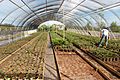
Native trees planted for conservation and wildlife.
-
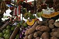
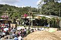
A vegetable stand at the Fiesta Acabe del Café in Maricao in 2014.
-
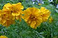
Yellow flowers blooming in Maricao.
-
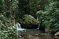
A water stream flowing through El Monte del Estado forest.
-
Hacienda Maricao, where the Fiesta Acabe del Café is celebrated.
-
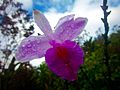
A beautiful orchid found in Maricao.
-
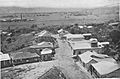
Maricao around the time of the Spanish-American War (1898).
.jpg)


See also
 In Spanish: Maricao para niños
