Maricao State Forest facts for kids
Quick facts for kids Maricao State ForestSpanish: Bosque Estatal de Maricao |
|
|---|---|

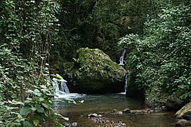
Water stream at El Monte del Estado
|
|
| Map | |
| Geography | |
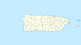
| Location | Maricao, Sabana Grande, San Germán |
| Coordinates | 18°07′22″N 66°58′29″W / 18.1227371°N 66.9746221°W |
| Elevation | 1,417 feet (432 m) |
| Area | 10,803 acres (43.72 km2) |
| Administration | |
| Established | 1919 |
| Governing body | Puerto Rico Department of Natural and Environmental Resources |
The Maricao State Forest (in Spanish: Bosque Estatal de Maricao) is a large state forest in Puerto Rico. It is found in the eastern part of the Cordillera Central, which is a mountain range. People often call it Monte del Estado because it was one of the first forest areas in Puerto Rico to be officially named a "state forest."
With an area of about 10,803 acres (43.72 km2), Maricao State Forest is the biggest of the 20 forest units in Puerto Rico's state forest system.
History
The Maricao State Forest was officially created on December 22, 1919. This happened after a special announcement by Arthur Yager, who was the Governor of Puerto Rico at that time.
Geography
The forest's location makes it very special in Puerto Rico. It has a humid climate, unique soils called serpentinite soils, and many plants and animals found nowhere else. The forest is located in the western part of Puerto Rico's Central Mountain Range. It covers about 10,803 acres (43.72 km2) of land in an area that gets a lot of rainfall. It stretches across the towns of San Germán, Sabana Grande, and Maricao.
Climate
In summer, the weather in the forest is warm and humid. Thunderstorms happen often. Daytime temperatures are usually around 85 °F (29 °C), and it can feel even hotter. At night, it usually cools down to the mid-60s °F (15-18 °C).
In winter, the forest is very dry. Daytime temperatures are mild, but nights can be cold. Sometimes, temperatures can drop to 40 °F (4 °C), and with wind, it can feel like the mid-30s °F (around 0 °C).
Geology
Almost all the soil in the Maricao forest comes from a type of rock called serpentinite. This is a metamorphic rock, which means it's a rock that has changed due to heat and pressure deep underground. When serpentinite breaks down, it creates red, clay-like soil.
More than 80% of the forest ground is not very deep. It is close to the bedrock, which is the solid rock layer beneath the soil. These soils are also acidic, meaning they have a low pH level. They contain a lot of iron and aluminum oxides, which are natural compounds.
Biology and ecology
Flora
The Maricao State Forest is home to 1,164 different kinds of plants. Out of the 128 plant species that are endemic to Puerto Rico (meaning they are found only there), 23 of them live in the Maricao State Forest. You can also find plantations of trees like mahogany, eucalyptus, and Honduras pine here.
Fauna
There are 136 types of birds that have been seen in the park. Twenty-three of these bird species are endemic to Puerto Rico, meaning they live only on the island.
Some examples of these special birds include the Puerto Rican sharp-shinned hawk (Accipiter striatus venator). This bird is an endangered subspecies, which means it is at risk of disappearing forever. Another example is the beautiful Puerto Rican emerald (Chlorostilbon maugaeus), a type of hummingbird.
Recreation
The Maricao State Forest is located along the Luis Muñoz Marín Scenic Route, also known as the Ruta Panorámica. This means the forest offers amazing views of the Cordillera Central mountains and the southwestern coast of Puerto Rico.
On clear days, you can even see the city of Mayagüez and sometimes even Mona Island from the Santa Ana Observation Tower. This tower is often called Torre de Piedra (Stone Tower). The forest also has many hiking trails. It is a popular spot for birdwatching, and many travel guides mention it as an important place to visit.
You can get to the hiking trails from route PR-120. You can also access them from the Monte del Estado Ecological Park (Parque Ecológico Monte del Estado) and the Monte del Estado Vacation Center (Centro Vacacional Monte del Estado). Both of these places offer some camping and lodging options for visitors.
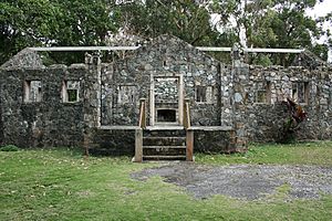
Besides the Torre de Piedra, there are other interesting historical places in the forest. One is the Stone House (Casa de Piedra), which are the ruins of a beautiful building. It was built in the 1930s as part of President Roosevelt's Civilian Conservation Corps projects, which created jobs during a difficult time.
Another historic site is the Maricao Fish Hatchery, built in 1937. It was used for research and is now listed on the National Register of Historic Places. This means it's recognized as an important historic site from the New Deal Era Constructions in the Forest Reserves of Puerto Rico (1933-1942).
Curet Falls (Salto Curet) is a stunning waterfall located along the Lajas River in the northeastern part of the forest. Other waterfalls you can find in the forest area include El Pilón and La Iglesia waterfalls.
See also
 In Spanish: Bosque estatal de Maricao para niños
 | Jessica Watkins |
 | Robert Henry Lawrence Jr. |
 | Mae Jemison |
 | Sian Proctor |
 | Guion Bluford |


