Las Marías, Puerto Rico facts for kids
Quick facts for kids
Las Marías
Municipio de Las Marías
|
|||
|---|---|---|---|
|
Town and Municipality
|
|||

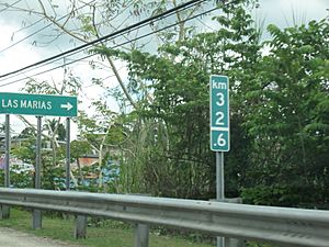
Sign for Las Marías on Puerto Rico Highway 129
|
|||
|
|||
| Nicknames:
"Pueblo de la China Dulce", "Ciudad de los Cítricos"
|
|||
| Anthem: "Por tus montes y tus aguas cristalinas" | |||

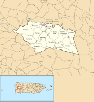
Map of Puerto Rico highlighting Las Marías Municipality
|
|||
| Sovereign state | |||
| Commonwealth | |||
| Settled | 1842 | ||
| Founded | July 1, 1871 | ||
| Founded by | Don Benito Recio y Moreno | ||
| Barrios | |||
| Area | |||
| • Total | 46.51 sq mi (120.5 km2) | ||
| • Land | 46.36 sq mi (120.1 km2) | ||
| • Water | .11 sq mi (0.3 km2) | ||
| Population
(2020)
|
|||
| • Total | 8,874 | ||
| • Rank | 75th in Puerto Rico | ||
| • Density | 190.798/sq mi (73.667/km2) | ||
| Demonym(s) | Marieños | ||
| Time zone | UTC−4 (AST) | ||
| ZIP Code |
00670
|
||
| Area code(s) | 787/939 | ||
| Major routes | |||
Las Marías is a beautiful town and municipality in Puerto Rico. It is located in the western part of the island. People from Las Marías are called Marieños. The town is often called "Pueblo de la China Dulce" (Sweet Orange Town) or "Ciudad de los Cítricos" (City of Citrus Fruits) because of its tasty oranges and other citrus fruits.
Las Marías is surrounded by other towns. It is north of Maricao and southeast of Añasco. To its south is San Sebastián, and to its east is Mayagüez. Finally, to its west is Lares. The municipality includes 13 main areas called barrios, plus the downtown area known as Las Marías Pueblo.
Contents
History
Las Marías was officially founded on July 1, 1871. Don Benito Recio y Moreno was the acting mayor when the town began.
After the Spanish–American War, Puerto Rico became a territory of the United States in 1898. A census in 1899 found that about 11,279 people lived in Las Marías.
On September 20, 2017, Hurricane Maria hit Puerto Rico very hard. In Las Marías, the strong winds and heavy rain caused many landslides. These landslides covered roads with mud, trees, and other debris. Some areas had more than 25 landslides per square mile due to the storm.
Geography
Las Marías is located on the central western side of Puerto Rico. The U.S. Census Bureau reported in 2010 that the municipality covers about 46.51 square miles. Most of this area, about 46.36 square miles, is land. Only a small part, 0.11 square miles, is water.
The Río Grande de Añasco, also known as Río Guacio, flows through Las Marías.
Barrios of Las Marías
Like all municipalities in Puerto Rico, Las Marías is divided into areas called barrios. The main town buildings, the central square, and a large Catholic church are located in a small barrio called "el pueblo".
Sectors of Las Marías
Barrios are further divided into smaller areas called sectores (which means sectors in English). These sectors can have different names like urbanización, reparto, barriada, or residencial.
Special Communities in Las Marías
Comunidades Especiales de Puerto Rico are special communities in Puerto Rico. These are areas where people might face challenges in their daily lives. In 2014, seven sectors in Las Marías were on this list: Sector La Josefa in Bucarabones, Sector Bryan in Cerróte, Sector Chamorro in Cerróte, Sector Palo Prieto in Palma Escrita, Sector Plato Indio in Río Cañas, Las Juanitas in Furnias, and Sector Santa Rosa in Furnias.
Population of Las Marías
| Historical population | |||
|---|---|---|---|
| Census | Pop. | %± | |
| 1900 | 11,279 | — | |
| 1910 | 10,046 | −10.9% | |
| 1920 | 10,736 | 6.9% | |
| 1930 | 8,881 | −17.3% | |
| 1940 | 9,626 | 8.4% | |
| 1950 | 10,807 | 12.3% | |
| 1960 | 9,237 | −14.5% | |
| 1970 | 7,841 | −15.1% | |
| 1980 | 8,747 | 11.6% | |
| 1990 | 9,306 | 6.4% | |
| 2000 | 11,061 | 18.9% | |
| 2010 | 9,881 | −10.7% | |
| 2020 | 8,874 | −10.2% | |
| U.S. Decennial Census 1899 (shown as 1900) 1910-1930 1930-1950 1960-2000 2010 2020 |
|||
The population of Las Marías has changed over the years. The numbers above show how many people lived in the municipality during different census years.
Tourism in Las Marías
Las Marías offers fun places for visitors. Paradise Camping Coffee Farm is a great spot for ecotourism and camping.
Landmarks and Places of Interest
Some interesting places to visit in Las Marías include:
- La Casona de Artemio
- Hacienda Palma Escrita
- Hacienda Frontera
- Finca Enseñat
Economy of Las Marías
Agriculture
Las Marías is known for its farming. The main crops grown here are bananas, coffee, and different types of citrus fruits like oranges.
Industry
The town also has some manufacturing. One important industry is making clothing.
Culture and Events
Festivals and Events
Las Marías celebrates its special patron saint festival in December. This festival, called Fiestas Patronales Inmaculada Concepción de María, is a religious and cultural event. It usually features parades, games, local crafts, fun rides, delicious regional food, and live music.
Other exciting festivals and events in Las Marías include:
- January - The Three King's Festival.
- March - The Orange Festival (Festival de las Chinas). This festival celebrates the town's famous citrus fruits. In 2019, a famous band called El Gran Combo performed, and troubadours from Cuba joined local Puerto Rican troubadours for music.
- March - The Festival to commemorate the founding of Las Marías (Festival de Las Marías).
Transportation
Las Marías has 13 bridges that help people travel around the municipality.
Symbols of Las Marías
The municipality of Las Marías has its own official flag and coat of arms.
Flag
The flag of Las Marías is divided by a diagonal line. The top left part is yellow, and the bottom right part is green. The yellow color represents the sun shining over the town. The green color stands for the beautiful nature and plants found in the municipality.
Coat of Arms
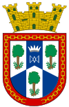
The shield of the coat of arms is divided into six sections, with three in silver and three in blue. In each silver section, you can see a María tree (Calophylum brasiliense antillanum). On the sides of the tree's trunk are branches from a coffee tree. In the top center of the shield, there is a special symbol and crown of Nuestra Señora la Santísima Virgen de Plata. The edge of the shield is red, and at the bottom, there is a broken chain. Above the shield, there is a golden crown with three towers.
See also
 In Spanish: Las Marías (Puerto Rico) para niños
 | Stephanie Wilson |
 | Charles Bolden |
 | Ronald McNair |
 | Frederick D. Gregory |


