Naranjales, Las Marías, Puerto Rico facts for kids
Quick facts for kids
Naranjales
|
|
|---|---|
|
Barrio
|
|

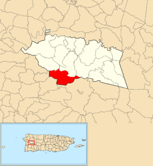
Location of Naranjales within the municipality of Las Marías shown in red
|
|
| Commonwealth | |
| Municipality | |
| Area | |
| • Total | 3.49 sq mi (9.0 km2) |
| • Land | 3.49 sq mi (9.0 km2) |
| • Water | 0 sq mi (0 km2) |
| Elevation | 1,499 ft (457 m) |
| Population
(2010)
|
|
| • Total | 558 |
| • Density | 159.9/sq mi (61.7/km2) |
| Source: 2010 Census | |
| Time zone | UTC−4 (AST) |
Naranjales is a special kind of neighborhood, called a barrio, located in the town of Las Marías, Puerto Rico. In 2010, about 558 people lived there. It's a part of Puerto Rico, which is a commonwealth of the United States.
Contents
A Look Back: History of Naranjales
How Puerto Rico Became Part of the U.S.
After the Spanish–American War ended in 1898, Spain gave Puerto Rico to the United States. This happened under the rules of the Treaty of Paris of 1898. From that point on, Puerto Rico became an unincorporated territory of the U.S. This means it's a part of the U.S. but doesn't have all the same rights as a state.
Early Population Counts
In 1899, the United States Department of War took a count of all the people in Puerto Rico. They found that the combined population of Naranjales and a nearby barrio called Furnias was 1,255 people.
| Historical population | |||
|---|---|---|---|
| Census | Pop. | %± | |
| 1980 | 425 | — | |
| 1990 | 352 | −17.2% | |
| 2000 | 485 | 37.8% | |
| 2010 | 558 | 15.1% | |
| U.S. Decennial Census 1899 (shown as 1900) 1910-1930 1930-1950 1980-2000 2010 |
|||
Exploring Naranjales: Sectors and Neighborhoods
What are Barrios and Sectors?
In Puerto Rico, a barrio is like a large district or area within a town. These barrios are then divided into even smaller local places. These smaller areas are called sectores (which means sectors in English).
Different Types of Sectors
Sectors can have different names depending on what kind of area they are. Some common types include:
- Sector: A general term for a small area.
- Urbanización: A planned housing development.
- Reparto: Another type of housing development.
- Barriada: Often an older, more established neighborhood.
- Residencial: A larger residential complex.
Sectors You Can Find in Naranjales
Here are some of the specific sectors located within the Naranjales barrio:
- Comunidad La Isabel
- Parcelas Alto Nieva
- Parcelas Plato Indio
- Sector Alto Manzano
- Sector Alto Nieva
- Sector Consumo
- Sector Herrería
- Sector La Cochera
- Sector La Josefa
- Sector La Loma de los Vientos
- Sector La Trapa
- Sector Merle
- Sector Retiro
- Tramo Carretera 106 (This refers to a section of Highway 106)
See also
 In Spanish: Naranjales (Las Marías) para niños
- List of communities in Puerto Rico
- List of barrios and sectors of Las Marías, Puerto Rico
 | Delilah Pierce |
 | Gordon Parks |
 | Augusta Savage |
 | Charles Ethan Porter |


