Bucarabones, Las Marías, Puerto Rico facts for kids
Quick facts for kids
Bucarabones
|
|
|---|---|
|
Barrio
|
|

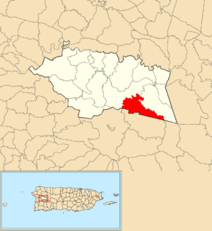
Location of Bucarabones within the municipality of Las Marías shown in red
|
|
| Commonwealth | |
| Municipality | |
| Area | |
| • Total | 2.89 sq mi (7.5 km2) |
| • Land | 2.89 sq mi (7.5 km2) |
| • Water | 0 sq mi (0 km2) |
| Elevation | 1,024 ft (312 m) |
| Population
(2010)
|
|
| • Total | 616 |
| • Density | 213.1/sq mi (82.3/km2) |
| Source: 2010 Census | |
| Time zone | UTC−4 (AST) |
Bucarabones is a small area, like a neighborhood, in the town of Las Marías, Puerto Rico. It is called a barrio. In 2010, about 616 people lived there.
History of Bucarabones
After the Spanish–American War, Spain gave Puerto Rico to the United States. This happened in 1898 because of a peace agreement called the Treaty of Paris of 1898. Puerto Rico then became a territory of the United States.
In 1899, the U.S. government counted the people in Puerto Rico. They found that 761 people lived in Bucarabones barrio at that time.
| Historical population | |||
|---|---|---|---|
| Census | Pop. | %± | |
| 1900 | 761 | — | |
| 1980 | 668 | — | |
| 1990 | 578 | −13.5% | |
| 2000 | 598 | 3.5% | |
| 2010 | 616 | 3.0% | |
| U.S. Decennial Census 1899 (shown as 1900) 1910-1930 1930-1950 1980-2000 2010 |
|||
Sectors in Bucarabones
Barrios, like Bucarabones, are often divided into even smaller parts. These smaller areas are called sectores (say: sek-TOH-res). Sectores means sectors in English.
There are different kinds of sectores. Some are just called sector. Others might be named urbanización, reparto, barriada, or residencial.
The following sectores are found in Bucarabones barrio:
- Sector Guilloty
- Sector La Constancia
- Sector La Josefa
- Sector Magueyes
- Sector Plan Bonito
See also
 In Spanish: Bucarabones (Las Marías) para niños
- List of communities in Puerto Rico
- List of barrios and sectors of Las Marías, Puerto Rico
 | Leon Lynch |
 | Milton P. Webster |
 | Ferdinand Smith |


