
Ceiba, Puerto Rico facts for kids
Quick facts for kids
Ceiba
Municipio de Ceiba
|
|||
|---|---|---|---|
|
Town and Municipality
|
|||

Town Hall of Ceiba
|
|||
|
|||
| Nicknames:
"Los Come Sopas", "La Ciudad del Marlin", "Los Sin Sopa"
|
|||
| Anthem: "Ceiba" | |||

Map of Puerto Rico highlighting Ceiba Municipality
|
|||
| Sovereign state | |||
| Commonwealth | |||
| Founded | April 7, 1838 | ||
| Founded by | Luis de la Cruz | ||
| Barrios | |||
| Area | |||
| • Total | 77.33 sq mi (200.28 km2) | ||
| • Land | 27.2 sq mi (70.5 km2) | ||
| • Water | 50.11 sq mi (129.78 km2) | ||
| Population
(2020)
|
|||
| • Total | 11,307 | ||
| • Rank | 73rd in Puerto Rico | ||
| • Density | 146.220/sq mi (56.456/km2) | ||
| Demonym(s) | ceibeños | ||
| Time zone | UTC−4 (AST) | ||
| ZIP Codes |
00735, 00742
|
||
| Area code(s) | 787/939 | ||
| Major routes | |||


Ceiba (pronounced say-bah) is a small town and municipality located in the northeast part of Puerto Rico. It gets its name from the famous Ceiba tree, which is a very important tree on the island. Ceiba is on the north-east coast, right by the Atlantic Ocean. It's south of Fajardo, north of Naguabo, and southeast of Río Grande. Ceiba is about an hour's drive from San Juan. The area includes 7 main parts called barrios and the downtown area, known as Ceiba Pueblo. It is also part of the larger Fajardo Metropolitan area.
Contents
History of Ceiba
Ceiba was officially started on April 7, 1838, by a person named Luis de la Cruz. The name "Ceiba" comes from an old Indian word, "Seyba," which is what they called the large Ceiba pentandra or kapok tree that grows there.
After the Spanish–American War, Puerto Rico was given to the United States by Spain in 1898. This happened under the rules of the Treaty of Paris of 1898. In 1899, the U.S. government counted all the people in Puerto Rico. At that time, the population numbers for Ceiba were combined with those of Fajardo.
Ceiba was once home to a large American military base called the Roosevelt Roads Naval Station. Most of the military units moved away, and the base closed in 2004. A former governor, Sila María Calderón, thought about turning the old base into a big international airport. The idea was to help the main airport in San Juan and bring more international flights to Puerto Rico. Some groups, like environmentalists, were worried about these plans. However, in 2008, the José Aponte de la Torre Airport was opened at the old base site.
People from Ceiba are often called "Los Come Sopa" which means 'the soup-eaters' in Spanish. No one knows exactly why they have this nickname. One story says that because the town didn't have a local meat market, people had to travel far to buy meat. So, they mostly ate soup.
On September 20, 2017, Hurricane Maria caused many landslides in Ceiba. Forty-nine buildings in an area called Punta Figuera were completely destroyed. In July 2018, some people received money from FEMA to help rebuild their homes.
-
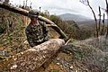
The National Guard helping out in Ceiba after Hurricane Maria.
.jpg)
Geography of Ceiba
The Reserva Natural Medio Mundo y Daguao (Medio Mundo and Daguao Nature Reserve) stretches along the coast between Ceiba and Fajardo. Most of this forest is made up of mangrove trees. You can see many different kinds of birds there, as well as turtles and gentle manatees. Ceiba also has rivers like the Río Daguao, Río Demajagua, and Río Fajardo.
The municipality of Ceiba extends into the ocean northwest, towards Fajardo and Culebra. This area includes coral reefs and small islands called Arrecifes Hermanos and Arrecifes Barriles. These reefs are closest to the coastal area of Machos.
The highest point in Ceiba is Pico del Oeste. It is part of the Sierra de Luquillo mountains and stands at 3,346 feet (1,020 meters) tall.
Barrios in Ceiba

Like all municipalities in Puerto Rico, Ceiba is divided into smaller areas called barrios. The main government buildings, the central town square, and a large Catholic church are located in a barrio known as "el pueblo", which is near the center of Ceiba.
Here are the barrios in Ceiba:
Sectors within Barrios
Barrios are further divided into even smaller local areas called sectores (which means sectors in English). These sectors can have different names like urbanización (urbanization), reparto (development), barriada (neighborhood), or residencial (housing complex).
Special Communities
Some communities in Puerto Rico are called Comunidades Especiales de Puerto Rico (Special Communities of Puerto Rico). These are areas where people might face challenges like not having enough resources or opportunities. In 2014, some of these special communities in Ceiba included Saco, Las Calderonas, Parcelas Aguas Claras, Parcelas Nuevas, Prado Hermoso, and Quebrada Seca.
Climate in Ceiba
| Climate data for Ceiba, Puerto Rico (Roosevelt Roads Naval Station) 1991–2020 normals, extremes 1942–present | |||||||||||||
|---|---|---|---|---|---|---|---|---|---|---|---|---|---|
| Month | Jan | Feb | Mar | Apr | May | Jun | Jul | Aug | Sep | Oct | Nov | Dec | Year |
| Record high °F (°C) | 90 (32) |
90 (32) |
90 (32) |
96 (36) |
91 (33) |
95 (35) |
95 (35) |
95 (35) |
93 (34) |
94 (34) |
96 (36) |
95 (35) |
96 (36) |
| Mean daily maximum °F (°C) | 82.9 (28.3) |
83.5 (28.6) |
84.2 (29.0) |
85.9 (29.9) |
86.7 (30.4) |
88.1 (31.2) |
88.8 (31.6) |
89.1 (31.7) |
88.8 (31.6) |
88.3 (31.3) |
86.2 (30.1) |
84.1 (28.9) |
86.4 (30.2) |
| Daily mean °F (°C) | 77.2 (25.1) |
77.5 (25.3) |
78.1 (25.6) |
79.6 (26.4) |
81.1 (27.3) |
82.7 (28.2) |
83.0 (28.3) |
83.4 (28.6) |
82.6 (28.1) |
82.0 (27.8) |
80.4 (26.9) |
78.4 (25.8) |
80.5 (26.9) |
| Mean daily minimum °F (°C) | 71.4 (21.9) |
71.4 (21.9) |
71.9 (22.2) |
73.3 (22.9) |
75.4 (24.1) |
77.3 (25.2) |
77.3 (25.2) |
77.6 (25.3) |
76.4 (24.7) |
75.7 (24.3) |
74.5 (23.6) |
72.8 (22.7) |
74.6 (23.7) |
| Record low °F (°C) | 61 (16) |
61 (16) |
59 (15) |
63 (17) |
64 (18) |
68 (20) |
66 (19) |
68 (20) |
68 (20) |
68 (20) |
65 (18) |
62 (17) |
59 (15) |
| Average precipitation inches (mm) | 2.62 (67) |
1.97 (50) |
1.84 (47) |
2.99 (76) |
6.71 (170) |
3.90 (99) |
4.31 (109) |
4.32 (110) |
6.40 (163) |
5.75 (146) |
6.07 (154) |
3.99 (101) |
50.87 (1,292) |
| Average precipitation days (≥ 0.01 in) | 16.4 | 13.2 | 13.6 | 13.0 | 15.3 | 15.4 | 18.9 | 18.1 | 17.9 | 17.7 | 18.3 | 18.1 | 195.9 |
| Source: NOAA | |||||||||||||
Population of Ceiba
| Historical population | |||
|---|---|---|---|
| Census | Pop. | %± | |
| 1920 | 5,973 | — | |
| 1930 | 7,275 | 21.8% | |
| 1940 | 7,021 | −3.5% | |
| 1950 | 9,199 | 31.0% | |
| 1960 | 9,075 | −1.3% | |
| 1970 | 10,312 | 13.6% | |
| 1980 | 14,944 | 44.9% | |
| 1990 | 17,145 | 14.7% | |
| 2000 | 18,004 | 5.0% | |
| 2010 | 13,631 | −24.3% | |
| 2020 | 11,307 | −17.0% | |
| U.S. Decennial Census 1920-1930 1930-1950 1960-2000 2010 2020 |
|||
Things to See and Do in Ceiba (Tourism)
To help people explore Puerto Rico, the Puerto Rico Tourism Company created a program called Voy Turistiendo ("I'm Touring"). It includes a passport book and a website. The Ceiba page suggests visiting Charco Frío y Las Tinajas, Playa Los Machos, and the mangrove forests at Medio Mundo y Daguao.
Landmarks and Places of Interest

According to a news article, Ceiba has about 60 beaches, including the popular Los Machos Beach.
Other interesting places to visit include:
- Ceiba Historic Mural
- Ceiba State Forest
- Ensenada Honda (a bay)
- Medio Mundo Beach
- Roosevelt Roads Base (a former U.S. Navy base that is now closed)
- The famous cellist Pablo Casals once lived in Ceiba.
Culture and Events
Festivals and Events
Ceiba celebrates its patron saint festival in June. This event, called Fiestas Patronales de San Antonio de Padua, is a religious and cultural celebration. It usually features parades, fun games, local artists selling their crafts, amusement rides, delicious regional food, and live music. Famous artists like Grupo Manía and Domingo Quiñones have performed there.
Other festivals and events in Ceiba include:
- Maratón de los Enamorados (Lovers' Marathon) - February
- Festival de Chiringas (Kite Festival) - March
- Festival de Marlin (Marlin Festival) - May or June
- Fiesta Nacional de la Raza (National Race Day Festival) - October
- Maratón del Pavo (Turkey Marathon) - November
Sports
Carlos Santos, a former world boxing champion, is from Ceiba. The town also has an amateur baseball team called Los Marlins de Ceiba. Pro golfer Chi-Chi Rodriguez is also from Ceiba.
Economy
Ceiba's economy mainly involves making things like plywood, clothing, and hardware products.
Transportation
The José Aponte de la Torre Airport in Ceiba offers flights, mostly within Puerto Rico, on three airlines. It also has an MD-82 jet that was given by American Airlines to help local students learn about airplane mechanics.
Ceiba has 29 bridges.
Famous People from Ceiba
Many notable people have connections to Ceiba:
- Carlos Santos - A former world champion in boxing.
- Luis Vigoreaux - A well-known radio and TV host, comedian, and producer.
- Domingo Quiñones - A famous singer who lived in Ceiba from age 4 to 14.
- Pablo Casals - A world-renowned cellist who built his home in Ceiba when he was 80 years old.
- Rogelio Figueroa Garcia - An engineer and politician who grew up in Ceiba. He helped start the Puerto Ricans for Puerto Rico (PPR) political party.
- McJoe Arroyo - A world boxing champion.
- McWilliams Arroyo - A professional boxer.
- Jaron Brown - A wide receiver who played for the Seattle Seahawks. He was born in Ceiba.
- Isabel Rosado Morales - Born in Ceiba, she was a rural teacher and a founding member of a social workers' society. She was also an activist for Puerto Rican independence and lived to be 107 years old.
Symbols of Ceiba
The municipio of Ceiba has its own official flag and coat of arms.
Flag
Ceiba's flag uses the same design and colors as its coat of arms. It has two vertical stripes of the same width. The left stripe is red, and the right stripe is green. On the red side, there is a yellow cross.
Coat of arms
The Ceiba coat of arms shows a shield with a Ceiba tree on it. At the top of the shield, there is a red section with a golden cross in the middle. On each side of the cross, there is a golden fleur-de-lis (a symbol that looks like a lily). The cross represents Christian faith and also honors Luis de la Cruz, who founded Ceiba. Around the shield, there are stalks of sugar cane. Above the shield, there is a golden Spanish fort.
See also
 In Spanish: Ceiba (Puerto Rico) para niños
