
Ceiba barrio-pueblo facts for kids
Quick facts for kids
Ceiba barrio-pueblo
Pueblo de Ceiba
|
|
|---|---|
|
Municipality Seat
|
|

Plaza and church in Ceiba barrio-pueblo
|
|

Location of Ceiba barrio-pueblo within the municipality of Ceiba shown in red
|
|

Ceiba barrio-pueblo
Location in Caribbean
|
|
| Commonwealth | |
| Municipality | |
| Area | |
| • Total | 0.55 sq mi (1.4 km2) |
| • Land | 0.55 sq mi (1.4 km2) |
| • Water | 0 sq mi (0 km2) |
| Elevation | 75 ft (23 m) |
| Population
(2010)
|
|
| • Total | 3,677 |
| • Density | 6,685.5/sq mi (2,581.3/km2) |
| Source: 2010 Census | |
| Time zone | UTC−4 (AST) |
Ceiba barrio-pueblo is a special area in Ceiba, a town in Puerto Rico. It's like the main downtown part of Ceiba. This area is where the local government offices are located. In 2010, about 3,677 people lived here.
In Puerto Rico, many towns have a central area called a pueblo. This pueblo usually has a main square, the town hall, and a church. Every year, special celebrations called Fiestas patronales (which means "patron saint festivals") are held in this central square.
The Main Square and Church
The central plaza, or main square, is a very important place in Ceiba barrio-pueblo. It's used for both official events and fun activities. People gather here to relax and socialize from morning until night.
Back in the early 1800s, Spanish laws called the Laws of the Indies guided how towns in Puerto Rico were built. These laws said that the main square should be big enough for celebrations. They also said that the streets nearby should have comfortable walkways. These walkways would protect people from the sun and rain.
Right across from the main square in Ceiba barrio-pueblo is a Roman Catholic church. It's called the Parroquia San Antonio de Padua. This church first opened its doors in 1840.
A Look at History
After the Spanish–American War, Spain gave Puerto Rico to the United States. This happened under the Treaty of Paris of 1898. Puerto Rico then became an unincorporated territory of the United States.
In 1899, the United States government took a count of all the people in Puerto Rico. This count is called a census. At that time, Ceiba barrio-pueblo was known as the Urban Zone (Zona Urbana). The census found that 753 people lived there.
You can see how the population of Ceiba barrio-pueblo has changed over the years in the table below:
| Historical population | |||
|---|---|---|---|
| Census | Pop. | %± | |
| 1900 | 753 | — | |
| 1910 | 920 | 22.2% | |
| 1920 | 847 | −7.9% | |
| 1930 | 1,204 | 42.1% | |
| 1940 | 1,442 | 19.8% | |
| 1950 | 1,665 | 15.5% | |
| 1980 | 3,008 | — | |
| 1990 | 3,650 | 21.3% | |
| 2000 | 3,816 | 4.5% | |
| 2010 | 3,677 | −3.6% | |
| U.S. Decennial Census 1899 (shown as 1900) 1910-1930 1930-1950 1980-2000 2010 |
|||
Local Areas: Sectors
Barrios, like Ceiba barrio-pueblo, are often divided into even smaller local areas. These smaller areas are called sectores (which means sectors in English).
There are different kinds of sectores. Some are simply called sector. Others might be named urbanización (like a housing development), reparto, barriada, or residencial (like a residential complex).
Here are some of the sectors you can find in Ceiba barrio-pueblo:
- Apartamentos Portal de Ceiba
- Condominio Costa Esmeralda
- Condominio Paseo Esmeralda
- Égida Francisco Colón Gordiani
- Residencia Solares Ávila
- Residencial Jardines de Ceiba
- Sector Colonia Santa María
- Urbanización Celina
- Urbanización Costa Brava
- Urbanización Jardines Ávila
- Urbanización Jardines de Ceiba I y II
- Urbanización Paseo de la Costa
- Urbanización Puerta del Sol
- Urbanización Ramos Antonini
- Urbanización Rossy Valley
- Urbanización Santa María
- Urbanización Villa Flores
Gallery
Here are some pictures of places in Ceiba barrio-pueblo:
-
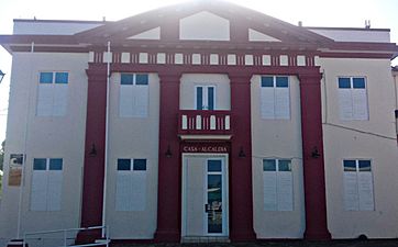
Ceiba Town Hall

See also
 In Spanish: Ceiba (Ceiba) para niños
- List of communities in Puerto Rico
- List of barrios and sectors of Ceiba, Puerto Rico
