
Naguabo, Puerto Rico facts for kids
Quick facts for kids
Naguabo
Municipio Autónomo de Naguabo
|
|||
|---|---|---|---|
|
Town and Municipality
|
|||

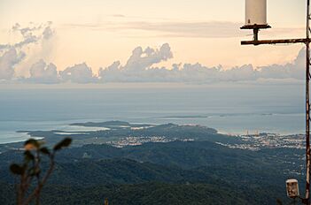
View of Naguabo from El Yunque
|
|||
|
|||
| Nicknames:
"Cuna de Grandes Artistas", "Los Enchumbaos"
|
|||
| Anthem: "Mi Naguabo del querer, Mi Naguabo del soñar" | |||

Map of Puerto Rico highlighting Naguabo Municipality
|
|||
| Sovereign state | |||
| Commonwealth | |||
| Settled | 1794 | ||
| Founded | July 15, 1821 | ||
| Founded by | Luis de Gaztambide, Juan Viera, Antonio Viera, and Juan Méndez | ||
| Barrios | |||
| Area | |||
| • Total | 60.1 sq mi (155.57 km2) | ||
| • Land | 52.1 sq mi (135 km2) | ||
| • Water | 7.9 sq mi (20.57 km2) | ||
| Population
(2020)
|
|||
| • Total | 23,386 | ||
| • Rank | 52nd in Puerto Rico | ||
| • Density | 389.1/sq mi (150.325/km2) | ||
| Demonym(s) | Naguabeños | ||
| Time zone | UTC−4 (AST) | ||
| ZIP Codes |
00718, 00744
|
||
| Area code(s) | 787/939 | ||
| Major routes | |||


Naguabo is a town and municipality located on the east coast of Puerto Rico. It sits by the Vieques Passage. To its north are Río Grande and Ceiba. To its south is Humacao, and to its east is Las Piedras. Naguabo is divided into 8 main areas called barrios, plus the downtown area known as Naguabo Pueblo. It is part of the larger San Juan-Caguas-Guaynabo Metropolitan Statistical Area.
Naguabo is famous for being the home of the pastelillo de chapín. This popular Puerto Rican food is made from trunkfish wrapped in deep-fried flour dough. You can find pastelillos de chapín at most places along the coast of the island.
Contents
History of Naguabo
The town of Naguabo was first started near a ravine on the east coast. In 1821, it was moved to where it is today. By 1878, Naguabo had several areas called barrios. These included Pueblo, Maizales, Duque, Mariana, Daguao, Santiago y Lima, Húcares, Río, Peña Pobre, and Río Blanco. Long ago, in 1521, the Daguao area was burned down by the Caribs.
After the Spanish–American War, Spain gave Puerto Rico to the United States in 1898. This made Puerto Rico a territory of the United States. In 1899, a count of the people in Puerto Rico showed that Naguabo had a population of 10,873.
On September 20, 2017, Hurricane Maria hit Puerto Rico very hard. In Naguabo, the coastal area of Playa Húcares was hit the worst. Many homes were destroyed or lost their roofs. The boardwalk was also ruined. More than 6,000 people in Naguabo reported losing property because of the hurricane.
Geography of Naguabo
Naguabo is located in the southeastern part of Puerto Rico. The highest point in the municipality is Pico del Este. This peak is part of the Sierra de Luquillo mountains and stands at 3,419 feet (1,042 meters) tall.
Two important rivers, Río Blanco and Río Espiritu Santo, are also found in Naguabo.
Barrios of Naguabo

Like all municipalities in Puerto Rico, Naguabo is divided into smaller areas called barrios. The main town buildings, the central square, and a large Catholic church are all located in the barrio known as "el pueblo".
Here are the barrios of Naguabo:
- Daguao
- Duque
- Húcares
- Maizales
- Mariana
- Naguabo barrio-pueblo
- Peña Pobre
- Río
- Río Blanco
- Santiago y Lima
Sectors and Communities
Barrios are often divided even further into smaller areas called sectores (sectors). These sectors can have different names like urbanización or barriada.
Some areas in Naguabo are called Special Communities (Comunidades Especiales). These are communities that need extra support. In 2014, some of these special communities in Naguabo included Relámpago neighborhood, Río, Santiago y Lima, Daguao, La Florida, Casco Urbano in barrio-pueblo, Húcares, Maizales, Parcelas La Fe, and Río Blanco.
Population of Naguabo
The number of people living in Naguabo has changed over the years. Here's a look at the population from different census counts:
| Historical population | |||
|---|---|---|---|
| Census | Pop. | %± | |
| 1900 | 10,873 | — | |
| 1910 | 14,365 | 32.1% | |
| 1920 | 15,788 | 9.9% | |
| 1930 | 18,212 | 15.4% | |
| 1940 | 19,180 | 5.3% | |
| 1950 | 21,019 | 9.6% | |
| 1960 | 17,195 | −18.2% | |
| 1970 | 17,996 | 4.7% | |
| 1980 | 20,617 | 14.6% | |
| 1990 | 22,620 | 9.7% | |
| 2000 | 23,753 | 5.0% | |
| 2010 | 26,720 | 12.5% | |
| 2020 | 23,386 | −12.5% | |
| U.S. Decennial Census 1899 (shown as 1900) 1910-1930 1930-1950 1960-2000 2010 2020 |
|||
In 2020, the population of Naguabo was 23,386 people. People from Naguabo are called Naguabeños.
Things to See and Do in Naguabo

Naguabo has 31 beaches to explore!
Some of the main attractions and interesting places in Naguabo include:
- Algodones Key
- El Yunque National Forest (You can reach the south side through PR State Road 191, but part of it might be closed.)
- Naguabo Beach
- Punta Lima Beach
- The monument for Ramón Rivero "Diplo", a famous artist.
- Tropical Beach
- Yudelmi Center
- The monument for Pedro Flores, a well-known composer.
- The Hucares Waterfront, also known as El Malecón (the boardwalk).
- The main town square, called Plaza De Recreo.
- Charco El Hippie, a popular swimming spot.
Culture and Events
Festivals and Celebrations
Naguabo celebrates its special patron saint festival in October. This event is called the Fiestas Patronales de Nuestra Virgen del Rosario. It's a fun religious and cultural celebration. You can usually see parades, play games, buy things from local artists, enjoy amusement rides, try regional food, and watch live shows.
Other exciting festivals and events in Naguabo are:
- Maratón Cervecero en Naguabo - held in January
- Chapín Festival - held in February
- Pedro Flores Week - held in March
- Diplo Festival - held in June
- Virgen del Carmen Fiesta - celebrated on July 16
Symbols of Naguabo
The municipality of Naguabo has its own official flag and a special design called a coat of arms.
Flag
Naguabo has a unique flag that represents the town.
Coat of arms
Naguabo also has a coat of arms, which is a special symbol or emblem.
Getting Around Naguabo
Naguabo has public transportation. A bus called "Pisicorre" operates from 6:00 a.m. to help people get around. There are also 52 bridges in Naguabo, helping connect different parts of the municipality.
Gallery
-
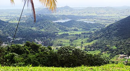
Río Blanco reservoir in Naguabo
-
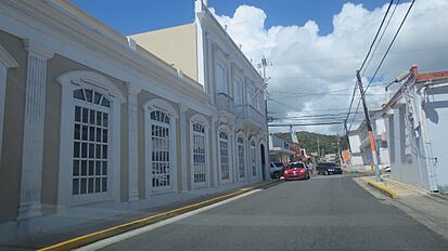
Street in Naguabo
-
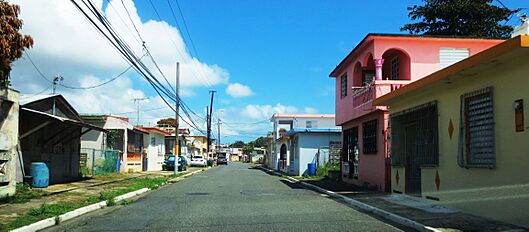
Residential street in Naguabo
-
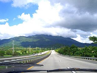
Highway from Naguabo to Ceiba
-
Northeast Puerto Rico from atop El Yunque
-
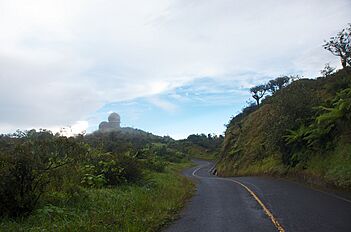
Radar towers in Naguabo


.jpg)
See also
 In Spanish: Naguabo para niños
