Peña Pobre facts for kids
Quick facts for kids
Peña Pobre
|
|
|---|---|
|
Barrio
|
|

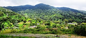
View of El Toro peak from Peña Pobre
|
|

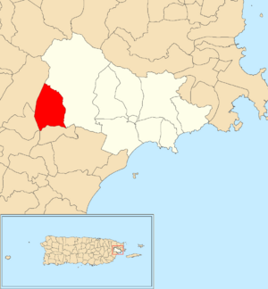
Location of Peña Pobre within the municipality of Naguabo shown in red
|
|
| Commonwealth | |
| Municipality | |
| Area | |
| • Total | 4.38 sq mi (11.3 km2) |
| • Land | 4.38 sq mi (11.3 km2) |
| • Water | 0 sq mi (0 km2) |
| Elevation | 413 ft (126 m) |
| Population
(2010)
|
|
| • Total | 4,131 |
| • Density | 943.2/sq mi (364.2/km2) |
| Source: 2010 Census | |
| Time zone | UTC−4 (AST) |
Peña Pobre is a community, also called a barrio, located in the town of Naguabo, Puerto Rico. In 2010, about 4,131 people lived there. It is a part of Puerto Rico, which is a commonwealth of the United States.
Contents
A Look Back: Peña Pobre's History
Puerto Rico used to be part of Spain. After the Spanish–American War in 1898, Spain gave Puerto Rico to the United States. This made Puerto Rico an unincorporated territory of the U.S.
In 1899, the United States government counted everyone living in Puerto Rico. This count is called a census. The census found that 1,064 people lived in Peña Pobre barrio at that time. Over the years, the number of people living in Peña Pobre has grown.
| Historical population | |||
|---|---|---|---|
| Census | Pop. | %± | |
| 1900 | 1,064 | — | |
| 1910 | 1,367 | 28.5% | |
| 1920 | 1,517 | 11.0% | |
| 1930 | 1,693 | 11.6% | |
| 1940 | 1,798 | 6.2% | |
| 1950 | 1,990 | 10.7% | |
| 1980 | 3,152 | — | |
| 1990 | 3,814 | 21.0% | |
| 2000 | 3,872 | 1.5% | |
| 2010 | 4,131 | 6.7% | |
| U.S. Decennial Census 1899 (shown as 1900) 1910-1930 1930-1950 1980-2000 2010 |
|||
Understanding Peña Pobre's Sections
Communities in Puerto Rico, like Peña Pobre, are divided into smaller areas. These smaller areas are called sectores (say: sek-TOR-es). Think of them like neighborhoods within a larger community.
There are different types of sectores. Some are simply called sector. Others might be named urbanización (a planned neighborhood), reparto, barriada, or residencial.
Here are some of the sectores you can find in Peña Pobre:
- Callejón Mendoza
- Parcelas Nuevas
- Parcelas Playa
- Parcelas Viejas
- Sector Centro
- Sector Ciénaga
- Sector El Molino Rojo
- Sector El Pilón
- Sector Fanduca
- Sector Higüerillo
- Sector La Loma
- Sector La Suiza
- Sector Los Benítez
- Sector Mambiche Blanco
- Sector Medianía Alta
- Sector Medianía
- Sector Peña Pobre Abajo
- Sector Peña Pobre Arriba
- Sector Villa Terapia
- Urbanización Villa de Monte Cristo
Community Spirit: After Hurricane Maria
On September 20, 2017, Hurricane Maria hit Puerto Rico very hard. Peña Pobre was one of the communities that suffered a lot of damage. Roads were destroyed, and it was hard for people to find food or gas.
Despite the challenges, the community showed amazing strength. Members of a local church, Jesucristo Monte Moriah, teamed up with an organization called World Central Kitchen and its founder, José Andrés. They worked together to prepare meals for families.
Peña Pobre is located in the mountains, with steep and winding roads. Even with the difficult conditions, the community cooked and delivered meals to families who couldn't get food for themselves. This showed how people can come together to help each other during tough times.
See also
- List of communities in Puerto Rico
- List of barrios and sectors of Naguabo, Puerto Rico
 In Spanish: Peña Pobre (Naguabo) para niños
 | Janet Taylor Pickett |
 | Synthia Saint James |
 | Howardena Pindell |
 | Faith Ringgold |


