
Ensenada Honda (Ceiba, Puerto Rico) facts for kids
Quick facts for kids Ensenada Honda (Deep Cove), Ceiba, Puerto Rico |
|
|---|---|
.jpg)
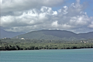
Aerial view of Ensenada Honda, Ceiba PR
|
|

Location in Puerto Rico
|
|
| Location | Ceiba, Puerto Rico |
| Coordinates | 18°12′41″N 65°36′54″W / 18.21139°N 65.61500°W |
| Type | Bay |
| Ocean/sea sources | North Atlantic Ocean |
| Managing agency | Department of Natural and Environmental Resources, Puerto Rico Ports Authority |
| Surface area | 1,664 acres (673 ha) |
| Max. depth | 40.5 ft (12.3 m) |
| Islands | Cabras Island Light |
| Settlements | Ceiba, Puerto Rico |
Ensenada Honda (which means "Deep Cove" in English) is a special inlet, or narrow arm of the sea, located on the northeastern coast of Puerto Rico. It's found in the town, or municipality, of Ceiba.
For a long time, this area was mostly left alone by the Spanish rulers because there wasn't much gold, and the local people fought back. This made it a secret spot for pirates and smugglers. Later, in the 1800s, the bay helped the sugarcane industry grow. In the 1900s, it became home to a very important U.S. Navy base called Roosevelt Roads Naval Station.
Today, a part of the military still uses the area, but Ensenada Honda is also a popular place for tourism and fishing. There are also special projects to protect its natural beauty, thanks to agreements with the U.S. Navy.
Contents
Exploring Ensenada Honda's Geography
Ensenada Honda covers about 4.6 square miles. It's quite deep, reaching a maximum of 40.5 feet. This makes it the second deepest bay in Puerto Rico, right after San Juan Bay. The bay is located near the "Vieques Strait," a busy water passage, and close to another important route called "Pasaje de Medio Mundo" (Middle of the World Passage).
The bay stretches about 2 miles to the northwest, between two land points called Cabra de Tierra and Punta Cascajo. Cabra de Tierra is a rocky, 35-foot-high point with some small trees. It separates Ensenada Honda from another bay called Bahía de Puerca.
Inside the bay, the water is generally 30 to 42 feet deep in the middle. The bottom of the bay is soft mud. Punta Cascajo is the western entrance point of Ensenada Honda. It's 69 feet high and has cliffs on its southern side. While the highest part of Punta Cascajo is clear, its shoreline is lined with mangrove trees.
A Look at Early History
We don't have many old written records about the eastern part of Borikén, which was the original name for Puerto Rico. However, ancient rock carvings found along the coast suggest that Ensenada Honda was a busy place long ago. It was likely a strong area for the Taíno people and the Kalinago (also known as Caribs) before Europeans arrived in 1493.
Before Columbus, a group of Kalinagos had started moving north from the Orinoco River area. They settled in the Lesser Antilles and reached nearby islands like Vieques and Culebra. By 1508, when Juan Ponce de León and other Spanish adventurers claimed San Juan Bay on the northern coast, the Caribs had likely taken control of Ensenada Honda. Reports from that time say that the Caribs would attack from the Vieques Strait area, working with rebellious Taíno leaders, called caciques, in the east.
.jpg)
The European invaders first came to Puerto Rico from the west. They were looking for gold and wanted to control the Taíno kingdoms. But the alliance between the eastern Taíno caciques and the more experienced Kalinagos from Vieques and Culebra slowed down the Spanish. This made the eastern coast less appealing for colonization.
Even though Ensenada Honda was a great natural harbor, no major port was built there for most of the Spanish colonial period. Instead, pirates and smugglers found the inlet very useful. It's even said that the famous Puerto Rican pirate, Roberto Cofresí, used Ensenada Honda to get to mainland Puerto Rico from Vieques and Culebra. In 1819, some South American rebels landed in Ensenada Honda but were pushed back by the local militia. This attack made the Spanish authorities pay more attention to the area.
In 1813, a historian named Iñigo Abbad y Lasierra mentioned Ensenada Honda in his book about Puerto Rico's history, but only briefly. It wasn't until 1836 that the leaders of the "Seiba" area decided to separate from the town of Fajardo and create their own town, Ceiba, next to the bay. They hoped that Ensenada Honda would help them export their farm products easily.
By the late 1800s, Ensenada Honda became a center for economic activities like timber, fishing, and sugarcane. In 1869, the Spanish government started planning a lighthouse on Cabras Island at the bay's entrance. Between 1879 and 1889, they even set aside the mangroves of Ensenada Honda as a natural preserve. However, in 1905, the U.S. Department of Agriculture, which was new to Puerto Rico, noted that Ensenada Honda was "one of the finest harbors in Porte Rico, which is wholly undeveloped."

The U.S. Navy became interested in Ensenada Honda and the nearby islands of Vieques and Culebra after the Spanish–American War in 1898. They saw its potential for military use. In 1919, a Navy officer named Lt. Robert L. Pettigrew suggested building a large naval complex there, connecting Vieques and Culebra to mainland Puerto Rico through Ensenada Honda.
In 1940, Captain R. A. Spruance used Pettigrew's idea to ask for a fleet base in Puerto Rico. The start of World War II and the threat of German submarines in the Caribbean Sea made the Navy even more eager to expand. They planned for the station at Ensenada Honda to become the "main fleet operation base in the Atlantic" and the Navy's largest complex.

In 1939, President Franklin D. Roosevelt appointed Admiral William D. Leahy as governor of Puerto Rico. His job was to prepare the island for war and help the Navy get the land they needed for bases. This happened at the same time as Puerto Rico's first land reform, which helped move farming families and buy land from small owners. Soon after, the Navy began buying property around Ensenada Honda. This brought many jobs and a booming local economy. The construction moved quickly, especially after the attack on Pearl Harbor, as people worried Puerto Rico might be the next target. German submarines even sank eight ships heading to Puerto Rico between April and May 1942, showing the danger was real.
However, the economic boom didn't last. When construction jobs ended, the economy slowed down. Many people had lost their land because of the base. The town of Ceiba lost 8,500 of its 18,000 acres, which was about 47% of its land. This meant Ceiba, a coastal town, suddenly had very little access to its own coast. The military bases took over Ceiba's best farmlands and important coastal areas. More than 4,000 of Ceiba's 18,000 residents were forced to leave their homes. Many of these families had lived on the land for centuries, even if they didn't have official ownership papers. Building military bases often changed rural areas very quickly and deeply.
The Roosevelt Roads base officially closed in March 2004. The Navy transferred its property on the eastern end of Vieques to the Department of Interior, as required by law.
Ensenada Honda Today
In 2015, the Puerto Rico Department of Natural Resources received 70 acres of land around the cove back from the U.S. federal government. This land is now protected to help preserve its important natural resources.
