
Culebra, Puerto Rico facts for kids
Quick facts for kids
Culebra
Municipio de Culebra
Isla de Culebra
|
|||
|---|---|---|---|
|
Island-Municipality
|
|||

Ensenada Honda in Culebra
|
|||
|
|||
| Etymology: Spanish: “Culebra”, i.e., (Non-venomous) Snake | |||
| Nicknames:
"La Isla Chiquita" (The Little Island), "Última Virgen" (Last Virgin), "Cuna del Sol Borincano" (Cradle of the Puerto Rican Sun)
|
|||
| Anthem: "Culebra Isla preciosa" | |||

Map of Puerto Rico highlighting Culebra Municipality
|
|||
| Sovereign state | |||
| Commonwealth | |||
| Founded | October 27, 1880 | ||
| Founded by | Don Cayetano Escudero | ||
| Barrios | |||
| Area | |||
| • Total | 30.1 km2 (11.6 sq mi) | ||
| • Land | 28 km2 (11 sq mi) | ||
| Population
(2020)
|
|||
| • Total | 1,792 | ||
| • Rank | 78th in Puerto Rico | ||
| • Density | 59.53/km2 (154.19/sq mi) | ||
| • Racial groups (2000 Census) |
60.6% White 20.9% Black 1.0% American Indian/AN 1.1% Asian 0.1% Native Hawaiian/Pi 13.0% Some other race 3.4% Two or more races |
||
| Time zone | UTC−4 (AST) | ||
| ZIP Code |
00775
|
||
| Area code(s) | 787/939 | ||
| Major routes | |||
.svg)

Culebra (pronounced koo-LAY-bra) is a beautiful island, town, and municipality that belongs to Puerto Rico. It's part of the Spanish Virgin Islands, located about 17 miles (27 km) east of mainland Puerto Rico. Culebra is also about 12 miles (19 km) west of St. Thomas and 9 miles (14 km) north of Vieques.
The island is divided into 5 areas called barrios and a main town called Culebra Pueblo (also known as Dewey). People who live on Culebra are called culebrenses. With a population of about 1,792 people (as of 2020), it's the least populated municipality in Puerto Rico.
Culebra has had many names over time, like Isla del Pasaje and Isla de San Ildefonso. Today, it's also known as Isla Chiquita ("Little Island"), Cuna del Sol Borincano ("Cradle of the Puerto Rican Sun"), and Última Virgen ("Last Virgin"). This last name comes from its location at the very end of the Virgin Islands chain.
Contents
History of Culebra
Early Days and Spanish Rule
Some people believe that Christopher Columbus was the first European to visit Culebra on November 19, 1493, during his second voyage. It's thought that Carib Indians lived on the island back then. After a rebellion in 1511, some Taíno Indians from the main island of Puerto Rico came to Culebra. They teamed up with the Caribs to attack Spanish settlements.
For many centuries, Culebra was mostly empty. It became a hiding spot for pirates and a place for local fishermen and sailors to rest. In the 1850s, a man named John Stevens was put in charge by the Spanish to protect the island from outsiders. Sadly, he was found dead in 1871, which caused a big international problem.
Because of these events, the Spanish government decided to settle Culebra with its own people. Cayetano Escudero Sanz officially started the settlement on October 27, 1880. The Spanish government offered land to anyone willing to move there. The first settlers had to rely on rainwater for drinking, as Culebra has no natural rivers. They started farming and raising animals. Their first settlement was named San Ildefonso.
In 1882, construction began on the Culebrita lighthouse, which was finished in 1886. It was the oldest working lighthouse in the Caribbean until it closed in 1975.
After the Spanish–American War in 1898, Spain gave Puerto Rico to the United States. In 1899, a census showed Culebra had 704 residents. In 1902, Culebra became part of Vieques. A year later, in 1903, President Theodore Roosevelt created the Culebra Naval Reservation. A bird refuge was also set up in 1909.
The United States Navy took over land around the main harbor to build a base. They asked all settlers to move. Two important ranchers, Antonio Lugo Suarez and Pedro Márquez Morales, helped the displaced residents find a new place to live. This new location, at Playa Sardinas, became the town of Dewey.
Pedro Márquez became the first mayor under U.S. rule in 1905. His son, Alejandro Márquez Laureano, became mayor in 1912 and built the first docks and added electric lights to the town's streets.
In 1911, the U.S. Navy reduced its presence on Culebra and started using it mainly for training. By 1924, the Navy began yearly exercises on Culebra, practicing landings and using its deep waters for training.
In 1939, the U.S. Navy started using Culebra for target practice with guns and bombs. This was to prepare for World War II. However, in 1971, the people of Culebra began strong protests, known as the Navy-Culebra protests. They wanted the U.S. Navy to leave their island.
These protests were led by Ruben Berrios, a lawyer and politician. Many people, including Berrios, were arrested for protesting on military land. Because of these protests, the U.S. Navy stopped using Culebra as a bombing range in 1975. All their operations were moved to Vieques. The cleanup of unexploded materials on the island is still ongoing.
Culebra became an independent island municipality in 1917. The first time its government was chosen by the people was in 1960. Before that, Puerto Rico's government appointed leaders for the island.
On September 20, 2017, Hurricane Maria hit Puerto Rico. Culebra had already been damaged by Hurricane Irma a week before, and Maria caused even more destruction.
Geography of Culebra

Culebra is an archipelago, which means it's a group of islands. It includes the main island and 23 smaller islands and keys nearby. Some of the biggest keys are Culebrita to the east, Cayo Norte to the northeast, and Cayo Luis Peña and Cayo Lobo to the west.
These islands are very dry, meaning they have no rivers or streams. All the fresh water for Culebra comes from Puerto Rico through an undersea pipeline that passes through Vieques.
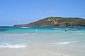
Culebra has an uneven landscape with a long, winding shoreline. The island is about 7 miles (11 km) long and 5 miles (8 km) wide. Its coast has cliffs, sandy coral beaches, and mangrove forests. The highest point on the island is Mount Resaca, which is 636 feet (194 meters) tall.
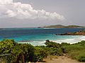
Ensenada Honda is the largest bay on the island. It's considered one of the safest harbors in the Caribbean during hurricanes. Culebra also has several lagoons, like Corcho, Flamenco, and Zoní.
Most of Culebra (about 80%) is made of volcanic rock. This land is mostly used for raising animals and some small-scale agriculture.
Average Sea Temperature
| Climate data for Average sea temperature | |||||||||||||
|---|---|---|---|---|---|---|---|---|---|---|---|---|---|
| Month | Jan | Feb | Mar | Apr | May | Jun | Jul | Aug | Sep | Oct | Nov | Dec | Year |
| Daily mean °F (°C) | 79.2 (26.2) |
78.3 (25.7) |
78.4 (25.8) |
80.1 (26.7) |
81.1 (27.3) |
82.6 (28.1) |
83.1 (28.4) |
84.2 (29.0) |
84.7 (29.3) |
84.2 (29.0) |
83.1 (28.4) |
81.3 (27.4) |
81.7 (27.6) |
| Source: SeaTemperatures.org | |||||||||||||
Nature Reserves

Many of Culebra's small islands and parts of the main island are protected nature reserves. One of the oldest bird sanctuaries in the United States was created in Culebra in 1909 by President Teddy Roosevelt.
Culebra is home to the Culebra Island giant anole, a very rare or possibly extinct lizard. The beaches are important nesting sites for sea turtles like leatherbacks, green sea turtles, and hawksbills. The bird sanctuaries are a home for many seabirds, including brown boobies, laughing gulls, and sooty terns. About 50,000 seabirds return to these sanctuaries every year! These reserves are protected by the United States Fish and Wildlife Service.
Culebra doesn't have large native mammals. However, a small group of white-tailed deer was brought to the island in 1966 and can now be found in the eastern part.
Important Bird Area
Culebra and its nearby islets are recognized as an Important Bird Area (IBA) by BirdLife International. This is because they are important breeding colonies for many seabirds, including brown boobies, brown noddies, and sooty and royal terns.
Barrios and Sectors

Like all municipalities in Puerto Rico, Culebra is divided into smaller areas called barrios. These barrios are:
These barrios are then divided into even smaller areas called sectores (sectors). These can be different types of areas, like urbanización (urban areas) or barriada (neighborhoods).
Tourism in Culebra
.jpg)
Culebra is a very popular place for tourists, especially for people from mainland Puerto Rico, the United States, and Vieques.
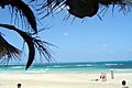
Culebra has many beautiful beaches. Flamenco Beach (Playa Flamenco) is one of the most famous. It was even ranked as the third best beach in the world by TripAdvisor in 2014! In 2017, Forbes magazine called it one of the top 50 beaches globally. You can get there by shuttle buses from the ferry. The beach has a mile of white coral sand and is surrounded by dry, tree-covered hills. It's also protected as a marine wildlife reserve.
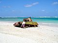
The area near Flamenco Beach was once used by the United States Navy and Marine Corps for military training until 1975. You can still see two old M4 Sherman tanks on the beach, which were used for target practice.

Other beaches on Culebra can only be reached by private car or boat. Of the smaller islands, only Culebrita and Luis Peña allow visitors. You can get to them by water taxis from Culebra. On these small islands, you can enjoy hiking and taking nature photos. However, activities that might harm the nature reserves, like camping (except at Flamenco Beach), littering, or using motor vehicles, are not allowed.
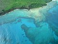
Culebra is also a favorite spot for scuba divers. This is because of the many coral reefs and the super clear waters around the islands. Since there are no rivers or streams, the water stays very clean and clear.
Landmarks and Places of Interest
To encourage people to visit, the Puerto Rico Tourism Company has a campaign called Voy Turistiendo ("I'm Touring"). Culebra's page lists these interesting places:
- Flamenco Beach (ranked as one of the most exotic beaches in the world!)
- Brava Beach
- Las Vacas Beach
- Larga Beach
- Pueblo Español
- Punta Soldado Beach
- Resaca Beach
- Tamarindo Beach
- Tortuga Beach
- Zoní Beach
- Faro de Culebrita (Culebrita Lighthouse)
- Reserva Natural del Canal Luis Peña (Luis Peña Channel Natural Reserve)
- Culebra's Historical Museum (an old U.S. Navy building)

Culture of Culebra
Festivals and Events
Culebra celebrates its patron saint festival in July. This event, called Fiestas Patronales de Nuestra Señora del Carmen, is a religious and cultural celebration honoring Mary, the mother of Jesus. It usually includes parades, games, local crafts, fun rides, traditional food, and live music.
Other fun events and festivals on Culebra include:
- Windsurfing competition – February
- Fishing tournament – March
- Craft festivities – November
In 2020, the family of Pedro Márquez put up a plaque to remember him. It's located where his butcher shop used to be, on the main street named after him.
Economy of Culebra

In the past, agriculture was the main way people made money on Culebra. They grew and exported many things like wood, tobacco, plantains, pumpkins, beans, yams, garlic, maize, tomatoes, oranges, and coconut. They also raised livestock like pigs, goats, and turkey.
Today, Culebra's main income comes from construction and tourism.
Population of Culebra
| Historical population | |||
|---|---|---|---|
| Census | Pop. | %± | |
| 1900 | 704 | — | |
| 1910 | 1,315 | 86.8% | |
| 1920 | 839 | −36.2% | |
| 1930 | 847 | 1.0% | |
| 1940 | 860 | 1.5% | |
| 1950 | 887 | 3.1% | |
| 1960 | 573 | −35.4% | |
| 1970 | 732 | 27.7% | |
| 1980 | 1,265 | 72.8% | |
| 1990 | 1,542 | 21.9% | |
| 2000 | 1,868 | 21.1% | |
| 2010 | 1,818 | −2.7% | |
| 2020 | 1,792 | −1.4% | |
| U.S. Decennial Census 1899 (shown as 1900) 1910-1930 1930-1950 1960-2000 2010 2020 |
|||
As of 2020, Culebra has a population of 1,792 people. This makes it the least populated municipality in all of Puerto Rico.
In 1894, reports showed that 519 people lived in five communities on Culebra.
Notable People from Culebra
- Pedro Morales (1942–2019) was a famous professional wrestler from Puerto Rico. He was the first Latino to become a world heavyweight champion when he won the WWE World Heavyweight Championship in 1971.
- The Ávila Brothers (Andrés, Pedro, Norberto, Justino, Guillermo, and Tomás) were six soldiers honored for their brave service in the Korean and Vietnam wars. A street in Culebra (PR-251) is named after them.

Symbols of Culebra
The municipality of Culebra has its own official flag and coat of arms.
Flag
The Culebra flag has five vertical stripes. Three of them are yellow, and two are green, alternating. In the middle yellow stripe, there is a green map of Culebra island.
Coat of Arms
The Culebra coat of arms has three sections: green, silver, and gold. The cross and the bishop's staff represent Bishop San Ildefonso, which was the island's original name. The snake (culebra means snake in Spanish) wearing a crown is a symbol of the island's name. The armored arm represents the Escudero family, who were among the first settlers. The laurel cross stands for the victory when the United States Navy left Culebra. At the top, there's a crown with two ship masts, symbolizing sailing and the sea.
Education in Culebra
Because Culebra is a small island with a small population, it only has three schools:
- San Ildefonso Elementary School
- Antonio R. Barceló High School
- Luis Muñoz Rivera School
The Puerto Rico Department of Education manages these schools.
Transportation to Culebra
You can get to Culebra by private boat, by the Culebra Ferry, or by airplane.
Ferry service is available from Ceiba on the main island. Ferries make several trips a day, and a round trip costs about $4.50.
Culebra also has a small airport called Benjamín Rivera Noriega Airport. It has flights to mainland Puerto Rico and Vieques. Small airlines like Air Flamenco and Vieques Air Link offer these services.
Once on the island, you can find public transportation like public cars and taxis. There is also one bridge on the island.
The Navy–Culebra protests were a series of protests that began in 1971 on Culebra. People were protesting against the United States Navy using the island for military training. These protests eventually led to the U.S. Navy leaving Culebra.
For many years, the U.S. Navy used Culebra and its nearby waters as a training area. This included practicing naval gunfire and aircraft bombing. These training exercises were very important during World War II and the Korean War. By 1969, the Navy's exercises on Culebra were at their peak.
In 1971, the people of Culebra started protesting to get the Navy to leave. Ruben Berrios, the president of the Puerto Rican Independence Party, led these protests. Many protesters, including Berrios, sat on military land as an act of civil disobedience. They were arrested and put in prison for trespassing.
Because of these strong protests, the U.S. Navy stopped using Culebra as a gunnery range in 1975. All their training operations were moved to Vieques. The process of cleaning up unexploded materials on Culebra has been slow, and the United States Army Corps of Engineers is still working on it.
Images for kids
-
Flamenco Beach
-
Flamenco Beach
-
An old tank at Flamenco Beach
-
Church at the town plaza
-
Flamenco Beach
-
Northwestern Flamenco Bay
-
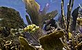
Culebra's corals
-
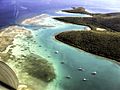
Ensenada Honda
-
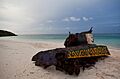
M4A3 Sherman tank at Flamenco Beach.
-
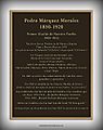
Centennial Plaque for Pedro Marquez


See also
 In Spanish: Isla Culebra (Puerto Rico) para niños
