
Corozal, Puerto Rico facts for kids
Quick facts for kids
Corozal
Municipio Autónomo de Corozal
|
|||
|---|---|---|---|
|
Town and Municipality
|
|||
|
From top, left to right: Corozal city hall in downtown Corozal; Parroquia Sagrada Familia (Sacred Family Parish); Town square of Corozal; historic Mavilla Bridge; and Panoramic mountainous views from barrios Cibuco and Magueyes
|
|||
|
|||
| Nicknames:
"La Capital del Voleibol", "Los Plataneros"
|
|||
| Anthem: "En Dios y Corozal todos unidos" | |||

Map of Puerto Rico highlighting Corozal Municipality
|
|||
| Sovereign state | |||
| Commonwealth | |||
| Founded | April 27, 1795 | ||
| Founded by | Francisco de Neve | ||
| Barrios | |||
| Area | |||
| • Total | 42 sq mi (109 km2) | ||
| • Land | 42 sq mi (109 km2) | ||
| • Water | 0 sq mi (0 km2) | ||
| Population
(2020)
|
|||
| • Total | 34,571 | ||
| • Rank | 35th in Puerto Rico | ||
| • Density | 821/sq mi (317.2/km2) | ||
| Demonym(s) | Corozaleños | ||
| Time zone | UTC−4 (AST) | ||
| ZIP Code |
00783
|
||
| Area code(s) | 787/939 | ||
| Major routes | |||
.jpg)
.jpg)
.jpg)
.jpg)


Corozal (Spanish pronunciation: [koɾoˈsal]) is a town and municipality in Puerto Rico. It is located in the central-eastern part of the island. Corozal is north of Orocovis and Barranquitas. It is south of Vega Alta and southwest of Toa Alta. To its east is Naranjito, and to its west are Morovis and Orocovis.
The municipality includes 12 smaller areas called barrios, plus Corozal Pueblo. Corozal Pueblo is the main downtown area and the center of the city's government. The city is part of the larger San Juan-Caguas-Guaynabo Metropolitan Statistical Area.
The name Corozal comes from the "palma de corozo" (grugru palm, Acrocomia media). This type of palm tree grows a lot in the central mountain range of Puerto Rico.
Contents
History of Corozal
Corozal has a rich history, starting with its original inhabitants.
Early History and Founding
The local Taíno Indian chief (called a Cacique) of this area was named Orocobix. His tribe was known as the Jatibonicu Taíno.
Corozal was officially founded in 1795. It became a recognized town in 1804. It is often called La Cuna del Volibol, which means Volleyball's Cradle. The town's name comes from the Acrocomia media palm tree, known in Puerto Rico as the Spanish: palma de corozo.
Becoming a U.S. Territory
After the Spanish–American War, Puerto Rico was given to the United States by Spain. This happened under the Treaty of Paris of 1898. In 1899, a census by the United States Department of War found that Corozal had a population of 11,508 people.
From 1902 to 1905, Corozal was joined with Toa Alta, a nearby municipality.
Population Growth
By the year 2000 census, Corozal's population had grown to 36,867 people. Its land area was about 43 square miles (109 km2).
Hurricane Maria's Impact
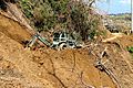
On September 20, 2017, Hurricane Maria hit Puerto Rico with strong winds and heavy rain. This caused many landslides in Corozal. Some bridges and homes were destroyed. Many residents had to collect spring water because clean drinking water was hard to find.
During the hurricane, the police station in Corozal flooded suddenly. Nineteen officers were inside. They climbed to the rooftop and formed a human chain to avoid being swept away. Young people from the community helped rescue them. They cut tree limbs and debris to lower the river's water level. Then, using a firehose, they waded through deep water to help the officers get to safety.
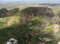
Geography of Corozal
Corozal is known for its beautiful mountainous landscape.
Location and Features
Corozal is located in the mountainous region near the center of Puerto Rico. Quebrada Jacinta is a valley found in Corozal.

Rivers and Waterways
Corozal has many rivers and streams. These include Río Cibuco, Río Corozal, Río Dos Bocas, Río Grande de Manatí, Río Mavilla, Río Orocovis, and Río Unibón. Because of these many waterways, Corozal can be very affected by major hurricanes.
Barrios and Sectors

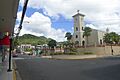
Like all municipalities in Puerto Rico, Corozal is divided into smaller areas called barrios. The main government buildings, the central town square, and a large Catholic church are located in the barrio known as "el pueblo."
Here are the barrios of Corozal:
- Abras
- Cibuco
- Corozal barrio-pueblo
- Cuchillas
- Dos Bocas
- Magueyes
- Maná
- Negros
- Padilla
- Palmarejo
- Palmarito
- Palos Blancos
- Pueblo
Barrios are further divided into even smaller areas called sectores (sectors). These sectors can have different names like urbanización or barriada.
Climate
Corozal has a tropical climate. This means it is generally warm all year round.
| Climate data for Corozal, Puerto Rico | |||||||||||||
|---|---|---|---|---|---|---|---|---|---|---|---|---|---|
| Month | Jan | Feb | Mar | Apr | May | Jun | Jul | Aug | Sep | Oct | Nov | Dec | Year |
| Record high °F (°C) | 88 (31) |
90 (32) |
95 (35) |
97 (36) |
98 (37) |
98 (37) |
99 (37) |
98 (37) |
98 (37) |
98 (37) |
93 (34) |
91 (33) |
99 (37) |
| Mean daily maximum °F (°C) | 78 (26) |
80 (27) |
83 (28) |
84 (29) |
87 (31) |
88 (31) |
88 (31) |
88 (31) |
88 (31) |
87 (31) |
82 (28) |
79 (26) |
84 (29) |
| Mean daily minimum °F (°C) | 60 (16) |
60 (16) |
61 (16) |
65 (18) |
68 (20) |
70 (21) |
72 (22) |
72 (22) |
72 (22) |
70 (21) |
66 (19) |
62 (17) |
67 (19) |
| Record low °F (°C) | 43 (6) |
45 (7) |
45 (7) |
55 (13) |
58 (14) |
60 (16) |
64 (18) |
67 (19) |
64 (18) |
60 (16) |
50 (10) |
48 (9) |
43 (6) |
| Average precipitation inches (mm) | 3.55 (90) |
3.11 (79) |
1.02 (26) |
4.78 (121) |
8.55 (217) |
7.20 (183) |
6.20 (157) |
5.84 (148) |
7.60 (193) |
7.71 (196) |
8.47 (215) |
5.65 (144) |
69.68 (1,769) |
| Source: The Weather Channel | |||||||||||||
Things to Do in Corozal (Tourism)
Corozal offers several interesting places to visit.
Local Attractions
The Puerto Rico Tourism Company has a campaign called Voy Turistiendo ("I'm Touring"). It helps people discover local places. Corozal's page lists:
- Reserva Natural Monte Choca (Monte Choca Natural Reserve)
- Tres Cruces (Three Crosses)
- Gran Mural de la Cultura Corozaleña (Great Mural of Corozal Culture)
Museums and Historic Sites
Corozal is home to the Historical Center of Cibuco. This is a park and museum. It has old items from Puerto Rico's Taínos. It also displays objects, paintings, and artifacts about the town's history.
El Balalaika is a cafeteria that opened in 1962.

Landmarks and Places of Interest
- El Rancho Recreation Center
- El Jíbaro Centro Recreativo
- Cine-Teatro San Rafael de Corozal: A movie theater that reopened in 2017 after being closed for 28 years.
- Mavilla Bridge: A historic bridge.
Economy of Corozal
Corozal's economy relies on farming and local businesses.
Agriculture
Corozal is one of Puerto Rico's main producers of plantains. New small businesses are also growing. They produce eggs and hydroponic crops like lettuce and recao.
Local Businesses
The town has many craft businesses and offers various services.
Culture and Events
Corozal celebrates its traditions with lively festivals.
Festivals and Events
.jpg)
Corozal celebrates its patron saint festival in January. This is called the Fiestas Patronales de la Sagrada Familia. It is a religious and cultural celebration honoring the Holy Family. The festival usually includes parades, games, local artisans, fun rides, regional food, and live entertainment.
Other festivals and events in Corozal include:
- Corozal Carnival - June
- San Juan Bautista Carnival - June
- Plantain Festival - September
- Festival del Corozo - October
Sports in Corozal
Corozal is well-known for its success in volleyball.
Volleyball
- Plataneros de Corozal (Liga de Voleibol Superior Masculino): This men's team has won 9 national championships. Their most recent win was in 2009.
- Pinkin de Corozal (Liga de Voleibol Superior Femenino): This women's team holds a record with 18 national championships. Their most recent win was in 2022.
Swimming
Corozal has the Gold Fish Swim Team for kids and youth. A new Master's Swim Team was also started in 2008.
Population (Demographics)
Demographics refers to the study of a population. Here's how Corozal's population has changed over the years:
| Historical population | |||
|---|---|---|---|
| Census | Pop. | %± | |
| 1900 | 11,508 | — | |
| 1910 | 12,978 | 12.8% | |
| 1920 | 14,369 | 10.7% | |
| 1930 | 16,454 | 14.5% | |
| 1940 | 20,458 | 24.3% | |
| 1950 | 23,087 | 12.9% | |
| 1960 | 23,570 | 2.1% | |
| 1970 | 24,545 | 4.1% | |
| 1980 | 28,221 | 15.0% | |
| 1990 | 33,095 | 17.3% | |
| 2000 | 36,867 | 11.4% | |
| 2010 | 37,142 | 0.7% | |
| 2020 | 34,571 | −6.9% | |
| U.S. Decennial Census 1899 (shown as 1900) 1910-1930 1930-1950 1960-2000 2010 2020 |
|||
Transportation
Corozal has a network of bridges. There are 26 bridges in the municipality. The Mavilla Bridge in Corozal is a historic landmark. It is listed on the US National Register of Historic Places.
Symbols of Corozal
The municipality of Corozal has its own official flag and coat of arms.
Flag
The flag has three horizontal stripes of equal width. The top stripe is yellow, the middle is green, and the bottom is blue. Sometimes, the coat of arms is embroidered or printed on the middle green stripe.
Coat of Arms
The coat of arms has a gold background. It shows three corozo palm trees with their natural-colored fruit clusters. These trees are planted on a green landscape in front of mountains. At the bottom, there are blue and silver water waves with gold nuggets. The crown on top is gold with black stones.
The corozo palms represent the town's name and its river, which used to have many palms. The mountains show the high, striking mountains of Corozal. The waves stand for the Corozal River and the gold nuggets that were once found there by panning. The gold background represents hard work and the pure gold that was valued long ago. The crown is a symbol used for cities and towns.
Education
Corozal has several schools for students.
High Schools
Public high schools in Corozal include:
- Escuela Superior Emilio R. Delgado
- Escuela Superior Porfirio Cruz García High School (located in Barrio Cuchillas)
The only private high school is Colegio Sagrada Familia, which is in Barrio Pueblo.
Notable People from Corozal ("Corozaleños")
Many talented people have come from Corozal:
- Carmen E. Arroyo: The first Puerto Rican woman elected to the New York State Assembly.
- Lunay: A popular Reggaeton music artist.
- Maria del Carmen Arroyo: A member of the New York City Council.
- Viviana Ortiz Pastrana: A fashion model and Miss Universe Puerto Rico 2011.
- Eddie Perez: A politician who served as mayor of Hartford, Connecticut from 2001 to 2010.
- April Carrión: A drag queen who was a contestant on RuPaul’s Drag Race season 6.
- Ashleyann Lozada: (born 1991) A boxer.
Images for kids
-
Puerto Rico National Guard helping with Hurricane Maria relief in Corozal.
-
Landslides in Corozal caused by Hurricane Maria.
-
Some parts of Puerto Rico still had power outages 5 days after Hurricane Maria.
-

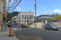
Building in Corozal barrio-pueblo
-
Parroquia La Sagrada Familia
-
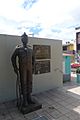
Statue in downtown Corozal
-
City hall
.jpg)


.jpg)
.jpg)
.jpg)

See also
 In Spanish: Corozal (Puerto Rico) para niños
